
MP28
| Location: Woomelang. | |
| Australian Soil Classification: Calcic, Mesonatric, Yellow SODOSOL (thick, sandy surface) | |
| General Landscape Description: Crest of a sandy rise within the Hopetoun Land System (Rowan and Downes, 1963). |
 Site MP28 Landscape. |
Soil Profile Morphology:
Surface Soil
| A1 | 0-15 cm | Brown (7.5YR4/4); loamy sand; weak consistence dry; pH 7.7; sharp change to: | 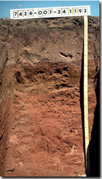 Site MP28 Profile |
| A2 | 15-45 cm | Reddish yellow (7.5YR6/6), conspicuously bleached (7.5YR7/4d); loamy sand; massive; weak consistence dry; sharp change to: | |
| Subsoil | |||
| B1 | 45-65 cm | Strong brown (7.5YR5/8); heavy sandy loam; weak blocky structure; weak consistence moist; pH 8.6: | |
| B21 | 65-70 cm | Yellowish red (5YR5/8); light sandy clay loam; sharp change to: | |
| B22 | 70-100 cm | Reddish yellow (7.5YR6/6); sandy clay loam; weak, coarsely structured; firm consistence, moist; pH 9.7: | |
| B23k | 100-150 cm | Yellowish red (5YR5/8); sandy clay; weak very coarse blocky structure; contains few fine earth carbonates and some hard carbonates (increasing with depth). | |
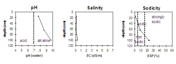
pH | Salinity Rating | |||
Surface (A1 horizon) | slightly alkaline | very low | non-sodic | none |
Subsoil (B21 horizon) | strongly alkaline | very low | sodic | moderate |
Deeper subsoil (at 70-100 cm) | extremely alkaline | very low | strongly sodic | strong |
 | ||||
Horizon | Horizon Depth (cm) | pH (water) | pH (CaCl2) | EC 1:5 | NaCI % | Exchangeable Cations | Field Capacity pF 2.5 | Wilting Point pF 4.2 | Coarse Sand (0.2 - 2.0 mm) | Fine Sand (0.02 -0.2 mm) | Silt (0.002 -0.02 mm) | Clay (<0.002mm) | |||
Ca | Mg | K | Na | ||||||||||||
meq/100g | |||||||||||||||
A1 | 0-15 | 7.7 | 7.3 | 0.09 | 9 | 0.9 | 0.6 | 0.1 | 5 | 4 | |||||
A2 | 15-45 | ||||||||||||||
B11 | 45-65 | 8.6 | 7.4 | 0.06 | 2.8 | 4.2 | 0.4 | 0.7 | 15 | 11 | |||||
B12 | 65-70 | ||||||||||||||
B21 | 70-100 | 9.7 | 8.7 | 0.32 | <0.05 | 2.5 | 6.1 | 1 | 2.9 | 38 | 29 | 1 | 30 | ||
Management Considerations:
Surface (A) Horizons
- The surface horizons have a low water holding capacity and are likely to become ‘droughty’ during periods of low rainfall. The low wilting point value (i.e. 3.5), however, indicates that plants will be able to utilise light rains falling on relatively dry soil. Heavier (i.e. more clayey) soils need to have considerable moisture stored before plants can have access to it.
- The surface soil has a low inherent nutrient status due to the high sand content and low clay content. Leaching of applied fertilisers is likely to be relatively high.
- Infiltration rates are likely to be relatively high for the sandy surface horizons.
- Organic matter and nitrogen levels are low for this pit site (which may or may not be representative of the whole paddock). Improving organic matter levels will increase soil fertility, water holding capacity and soil aggregation.
- Soluble salt levels are low throughout the subsoil.
- The deeper subsoil (from 80 cm depth) is extremely alkaline which indicates that phosphorus and some trace elements (e.g. iron, manganese, boron, copper and zinc) may be poorly available to plants. Deficiencies can be determined by plant tissue analysis.
- The subsoil is sodic and disperses. This is likely to restrict root and water movement at depth. In some ways this more restrictive layer can be of some benefit . It will ensure that water does not rapidly move beyond the root zone.
© State of Victoria (Agriculture Victoria) 1996 - 2025.

This work, Victorian Resources Online, is licensed under a Creative Commons Attribution 4.0 licence. You are free to re-use the work under that licence, on the condition that you credit the State of Victoria (Agriculture Victoria) as author, indicate if changes were made and comply with the other licence terms.
The licence does not apply to ‘branding’ or some ‘images or photographs’ that may be owned by third parties. We ask you to seek prior approval to use images using the VRO feedback form. Access to higher quality images can also be provided on request.
This page was last updated on 23/03/2020.