
MP22
| Location: Jil Jil. | Group: Birchip Cropping Group. |
| Australian Soil Classification: Epihypersodic, Pedal, Hypercalcic CALCAROSOL. | |
| General Landscape Description: Level plain within the Culgoa Land System (Rowan and Downes, 1963). | |
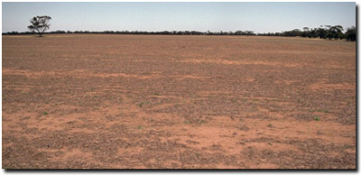 Site MP22 Landscape |
Soil Profile Morphology:
Surface Soil
| A1 | 0-10 cm | Dark brown (10YR3/3); clay loam; hardsetting and massive; firm consistence dry; pH 8.4; abrupt change to: | 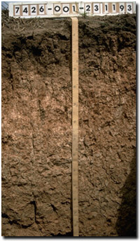 Site MP22 Soil Profile |
| Subsoil | |||
| B21 | 10-30 cm | Dark brown (10YR3/3); light medium clay; moderate coarse prismatic structure; very firm consistence dry; pH 8.8; wavy change to: | |
| B22k | 30-110 cm | Reddish yellow (5YR6/6); light medium clay; moderate coarse prismatic, parting to medium angular blocky structure; contains very few (<2%) ironstone fragments and many (20-50%) fine earth carbonates; pH 9.8; gradual change to: | |
| B23 | 110-125 cm | Reddish yellow (7.5YR6/6); medium heavy clay; moderate coarse prismatic, parting to medium to coarse blocky structure (smooth-faced peds); contains a few (2-10%) soft carbonates (and a band of manganese segregations in the 120 -125 cm zone); strong consistence dry; pH 8.6; gradual change to: | |
| B31 | 125 cm+ | Brownish yellow (10YR6/8) with light brownish grey (10YR6/2) mottles; medium clay; strong coarse prismatic, parting to coarse angular blocky structure (smooth-faced peds); strong consistence dry; pH 4.9. | |
Soil Profile Characteristics:
pH | Salinity Rating | |||
Surface (A1 horizon) | moderately alkaline | low | non-sodic | none |
Subsoil (B21 horizon) | strongly alkaline | low | non-sodic | none |
Deeper subsoil (at 1 m) | extremely alkaline | Very high | strongly sodic | strong |
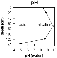 | 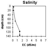 |  |
Horizon | Horizon Depth (cm) | pH (water) | pH (CaCl2) | EC 1:5 | NaCI % | Exchangeable Cations | Field Capacity pF 2.5 | Wilting Point pF 4.2 | Coarse Sand (0.2 - 2.0 mm) | Fine Sand (0.02 -0.2 mm) | Silt (0.002 -0.02 mm) | Clay (<0.002 mm) | |||
Ca | Mg | K | Na | ||||||||||||
meq/100g | |||||||||||||||
A1 | 0-10 | 8.4 | 7.6 | 0.18 | 20.7 | 4.2 | 3.1 | 0.2 | 29 | 16 | 32 | 25 | 4 | 29 | |
B21 | 10-30 | 8.8 | 8 | 0.17 | 5.6 | 13.4 | 1.3 | 1 | 34 | 20 | 36 | 22 | 2 | 34 | |
B22k | 30-110 | 9.8 | 8.7 | 0.53 | <0.05 | 5.6 | 13.4 | 1.2 | 6.7 | 41 | 26 | ||||
B23 | 110-125 | 8.6 | 8.1 | 1.47 | 0.25 | 1.8 | 13.1 | 1.5 | 13.9 | 46 | 27 | ||||
B31 | 125+ | 4.9 | 4.3 | 1.48 | .29 | 0.5 | 8 | .6 | 6.9 | ||||||
Management Considerations:
Surface (A) Horizon
- The hardsetting surface condition can be improved by using management practises such as minimum tillage, stubble retention and pasture rotations to improve organic matter levels.
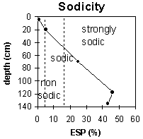
- The upper subsoil is non-sodic but becomes strongly sodic from 45 cm depth. This will result in plant and water movement being restricted in the deeper subsoil. The high level of exchangeable magnesium relative to exchangeable calcium is likely to reinforce the deleterious effects of exchangeable sodium on soil structure and may induce deficiencies in some nutrients.
- The level of soluble salts becomes high in the deeper subsoil, which will affect the growth of deeper-rooted salt-sensitive species.
- The subsoil is strongly to extremely alkaline throughout. This indicates that phosphorus and trace elements such as iron, manganese, copper and zinc may be poorly available to plants.
Profile Described By: Mark Imhof and John Martin (23/1/93).
© State of Victoria (Agriculture Victoria) 1996 - 2025.

This work, Victorian Resources Online, is licensed under a Creative Commons Attribution 4.0 licence. You are free to re-use the work under that licence, on the condition that you credit the State of Victoria (Agriculture Victoria) as author, indicate if changes were made and comply with the other licence terms.
The licence does not apply to ‘branding’ or some ‘images or photographs’ that may be owned by third parties. We ask you to seek prior approval to use images using the VRO feedback form. Access to higher quality images can also be provided on request.
This page was last updated on 23/03/2020.