
LWA4
| Location: Walpeup | Australian Soil Classification: Bleached, Hypercalcic, Yellow KANDOSOL |
| General Landscape Description: Crest of Dune | Site Description: Landcare delivery site |
| Geology:Quaternary aeolian deposits (Woorinen Formation) |
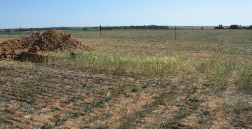 LWA4 Landscape |
Soil Profile Morphology:
Surface Soil
| A1 | 0-13 cm | Brown (7.5YR5/4); sand; loose; pH7.9: | 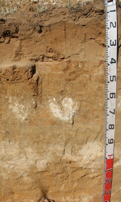 LWA4 Profile |
| A21 | 13-25 cm | Reddish yellow (7.5YR6/6); clayey sand; very weak to firm consistence (slightly moist); pH 7.9: | |
| A22 | 25-38 cm | Light brown (7.5YR6/4); sand; very weak consistence (dry); pH 8: | |
| |||
| B21 | 38-50 cm | Reddish yellow (7.5YR6/6); sandy loam (clayey); bleached capping to horizon; strong consistence (dry); pH 8.7: | |
| B22k | 50-75 cm | Pink (7.5YR7/4) with many (30%) reddish yellow (7.5YR6/6) mottles; sandy clay loam; weak to firm consistence (dry); soft and semi-hard carbonate ‘bombs’; pH 9.5: | |
| B23 | 75-95 cm | Light yellowish brown (10YR6/4) with very many (40%) reddish yellow (7.5YR6/6) mottles; sandy clay loam; pH 9.7: | |
| B24 | 95-115 cm | Light brown (7.5YR6/4); sandy clay loam; weak coarse (50-100 mm) blocky structure; very many (60-80%) fine-earth carbonates and semi-hard calcareous nodules; pH 9.9: | |
| 115-140 cm | Light brown (7.5YR6/4) with reddish yellow (7.5YR6/6) mottles; clayey sand; weak coarse to medium (10-50 mm) blocky structure; pH 9.9. | ||
Key Profile Features:
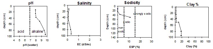
Soil Profile Characteristics:
pH | Salinity Rating | |||
Surface (Ap horizon) | Slightly alkaline | Low | Non-sodic | None |
Subsoil (B21 horizon) | Strongly alkaline | Low | Sodic | Strong |
Deeper subsoil (at 115-140 cm) | Extremely alkaline | Medium |
 |
Horizon | Horizon Depth | pH (water) | pH CaCl2 | EC 1:5 | Org. Carbon mg/kg | Exchangeable Cations | |||
Ca | Mg | K | Na | ||||||
Meq/100g | |||||||||
A1 | 0-13 | 7.9 | 7.5 | 0.12 | < 0.3 | 2.8 | 0.8 | 0.3 | 0.1 |
A21 | 13-25 | 7.9 | 7.4 | 0.06 | < 0.3 | 2.3 | 0.7 | 0.3 | 0.1 |
A22 | 25-38 | 8.0 | 7.5 | 0.06 | 2.0 | 0.7 | 0.3 | 0.2 | |
B21 | 38-50 | 8.7 | 7.9 | 0.08 | 3.1 | 3.0 | 0.5 | 0.9 | |
B22K | 50-80 | 9.5 | 8.8 | 0.29 | |||||
B23 | 80-95 | 9.7 | 9.0 | 0.34 | |||||
B24 | 95-115 | 9.9 | 9.1 | 0.54 | |||||
115-140 | 9.9 | 9.2 | 0.45 | ||||||
Horizon | Horizon Depth | Boron mg/kg | Field pF2.5 g/100g | Wilting Point pF4.2 g/100g | Coarse Sand (0.2-2.0mm) % | Fine Sand (0.02-0.2mm) % | Silt (0.002-0.02mm) % | Clay (<0.002mm) % |
A1 | 0-13 | 0.5 | 5.9 | 1.3 | 53 | 42 | <1.0 | 2 |
A21 | 13-25 | 0.6 | 8.2 | 1.7 | 48 | 45 | 1.5 | 2 |
A22 | 25-38 | 0.5 | 9.0 | 1.7 | 47 | 47 | 3 | 3 |
B21 | 38-50 | 1.3 | 14.9 | 5.6 | 39 | 47 | 4 | 10 |
B22K | 50-80 | 5.0 | 20.2 | 9.2 | 37 | 38 | 3 | 18 |
B23 | 80-95 | 11.0 | 18.4 | 8.2 | 36 | 41 | 5 | 18 |
B24 | 95-115 | 20.9 | 9.8 | |||||
115-140 |
Management Considerations:
Note:
- Soil characterised by Mark Imhof Jan 04.
© State of Victoria (Agriculture Victoria) 1996 - 2025.

This work, Victorian Resources Online, is licensed under a Creative Commons Attribution 4.0 licence. You are free to re-use the work under that licence, on the condition that you credit the State of Victoria (Agriculture Victoria) as author, indicate if changes were made and comply with the other licence terms.
The licence does not apply to ‘branding’ or some ‘images or photographs’ that may be owned by third parties. We ask you to seek prior approval to use images using the VRO feedback form. Access to higher quality images can also be provided on request.
This page was last updated on 23/03/2020.