
MP5
| Location: Walpeup. | Australian Soil Classification: Sodic, Hypercalcic, Red DERMOSOL. |
| Geology: Quaternary deposits. | Northcote Factual Key: Dy 2.43 |
| General Landscape Description: Crest of the Walpeup Ridge with Belah vegetation. | Property: Mallee Research Station |
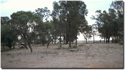 Site MP5 Landscape |
Soil Profile Morphology:
Surface Soil
| A11 | 0-5 cm | Dark reddish brown (5YR3/4); fine sandy loam; hardsetting surface condition; moderate fine blocky structure; weak consistence dry; slightly calcareous; pH 6.9; sharp and smooth change to: | 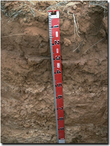 Site MP5 Profile |
| A12 | 5-30 cm | Yellowish red (5YR4/6); loamy sand; apedal; weak consistence dry; slightly calcareous; pH 7.2; sharp and smooth change to: | |
| A2 | 30-32 cm | Light reddish brown (5YR6/4) conspicuously bleached (5YR7/4 dry); sandy loam; massive in structure; weak consistence dry; slightly calcareous; sharp and smooth change to: | |
Subsoil | |||
| B1 | 32-37 cm | Dark red (2.5YR4/8); sandy loam; massive; very strong consistence dry; possible clay hardpan; slightly calcareous; pH 8.0; clear and smooth change to: | |
| B21 | 37-50 cm | Yellowish red (5YR5/6); clay loam (sandy); moderate blocky structure; slightly calcareous; pH 9.5: | |
| B22k | 50-90 cm | Yellowish red (5YR5/6); light clay (sandy); moderate coarse blocky structure; very strong consistence dry; contains many (20-50%) fine-earth carbonates and nodules; very highly calcareous; pH 9.6: | |
| B3k | 90+ cm | Yellowish red (5YR5/8); light clay (sandy); moderate blocky structure; contains very many (>50%) fine-earth carbonates; very highly calcareous; pH 9.6. | |
Note: At 160 cm depth horizontal carbonate piping occurs. | |||
Key Profile Features:
- Sandy hardsetting surface soil.
- The subsoil has a high accumulation of carbonates.
- Strongly sodic subsoil throughout.
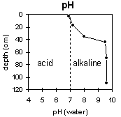 | 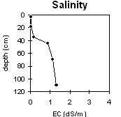 |
The surface soil is slightly acid. The upper subsoil is very strongly alkaline becoming extremely alkaline with depth. | The surface soil has a very low salinity rating. The upper subsoil is moderate becoming extremely high at 40 cm. |
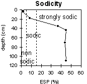 | 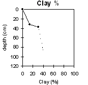 |
The surface soil is non-sodic but becomes sodic at about 10 cm. The subsoil is strongly sodic throughout. | The clay content increases gradually with depth. |
Whole Profile
- In general, management strategies for all soils should aim to: increase organic matter levels in the surface soil, minimise the degradation of soil aggregates and porosity, promote the development of stable biopores, break up any hardpans, and improve the calcium status of the ion exchange complex. Particularly when sodium plays a significant part i.e. the soil is sodic. Less frequent tillage, using less aggressive implements, and working the soil at optimum moisture conditions can all assist in maintaining soil aggregation and porosity, as well as reducing the breakdown of organic matter. Farming practices on cropping soils such as residue retention, minimum tillage and pasture rotations could be utilised to build up organic matter, reduce erosion risk and increase the soils low inherent fertility.
- Infiltration of water is likely to be high in the sandier surface horizons. The A2 (subsurface) horizon is conspicuously bleached, strongly leached and has a low inherent fertility. This layer sits on a very hard upper subsoil, although it is not considered a hard pan. This indicates that the A2 horizon is periodically waterlogged as water sits on the more slowly permeable subsoil.
Subsoil (B) Horizons
- The subsoil is very strongly to extremely alkaline. This indicates that some nutrients e.g. iron, manganese, zinc and copper, may be poorly available to plants and that deficiencies are likely to occur. Deficiencies should be determined by plant tissue analysis.
- Boron toxicity can also occur in strongly alkaline soils. However, boron levels were not measured at this site.
- The subsoil below 30 cm depth becomes strongly sodic, has a low exchangeable calcium to magnesium ratio and disperses when wet. This will result in restricted root and water movement into the subsoil. The upper subsoil is also quite hard which will further restrict root movement. If the soil is tilled while wet and the subsoil is disturbed, structural degradation is likely to occur.
- At about 40 cm the level of soluble salts becomes high. These levels are likely to restrict the growth of salt-sensitive species (e.g. faba beans, chickpeas, lupins).
Profile Described By: Mark Imhof, John Martin and Sonia Thompson (March 1994).
© State of Victoria (Agriculture Victoria) 1996 - 2025.

This work, Victorian Resources Online, is licensed under a Creative Commons Attribution 4.0 licence. You are free to re-use the work under that licence, on the condition that you credit the State of Victoria (Agriculture Victoria) as author, indicate if changes were made and comply with the other licence terms.
The licence does not apply to ‘branding’ or some ‘images or photographs’ that may be owned by third parties. We ask you to seek prior approval to use images using the VRO feedback form. Access to higher quality images can also be provided on request.
This page was last updated on 23/03/2020.