
MP4
Location: Walpeup
Australian Soil Classification: Endohypersodic, Pedal, Hypercalcic CALCAROSOL
Northcote Factual Key: Dr2.13
General Landscape Description: Open depression within a swale.
Site Description: Mallee Research Station lysimeter trial site. Completely cleared, pasture, cultivated as some stage in the past.
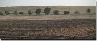 MP4 Landscape |
Soil Profile Morphology:
Surface Soil
| A1 | 0-10 cm | Reddish brown (5YR4/4); sandy loam; massive; very firm consistence dry; contains a few (2-10%) calcareous nodules; slight effervescence; pH 6.8; clear and smooth change to: | 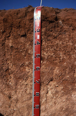 MP4 Profile |
Subsoil | |||
| B21 | 10-25 cm | Red (2.5YR4/8); light medium clay; moderate medium prismatic, structure; very firm consistence dry; moderate effervescence; pH 8.1; diffuse and wavy change to: | |
| B22 | 25-65 cm | Red (2.5YR4/8); light clay; moderate blocky structure; firm consistence dry; contains many (20-50%) soft calcareous segregations; very strong effervescence; pH 9.5; diffuse change to: | |
| B23 | 65- 200 cm | Olive (5Y5/8); light clay; strong consistence dry; contains a few (2-10%) calcareous nodules; very strong effervescence; pH 9.7: | |
| BC | 200+ cm | Heavy clay; coarse peds; pipe structures; contains a slight amount of manganese nodules; pH 8.7. | |
Soil Profile Characteristics:
pH | Salinity | |||
Surface (A1 horizon) | Slightly Acid | Low | Non-Sodic | None |
Subsoil (B21 horizon) | Moderately Alkaline | Very Low | Non-Sodic | None |
Deeper Subsoil (at 1 metre) | Extremely Alkaline | High | Extremely Sodic | Moderate |

| The surface horizon is slightly acid. The subsoil is moderately to strongly alkaline. | The salinity rating in the surface is low. The subsoil is also low becoming high with depth. | The surface and upper subsoil is non sodic. The deeper subsoil becomes extremely sodic | A sharp increase in clay occurs at the A/B horizon interface |
Chemical and Physical Analysis:
Horizon | Horizon Depth (cm) | pH (water) | pH (CaCl2) | EC dS/m | NaCl % | Exchangeable Cations | |||
Ca | Mg | K | Na | ||||||
meq/100g | |||||||||
A1 | 0-15 | 6.8 | 5.9 | 0.07 | 3.5 | 1.5 | 0.7 | <0.1 | |
A2 | 15-20 | 8.1 | 7.4 | 0.09 | 7.5 | 4.4 | 1.3 | 0.4 | |
A3 | 20-21 | 9.5 | 8.3 | 0.31 | <0.05 | 6.2 | 9.6 | 1.4 | 3.7 |
B21 | 21-35 | 9.7 | 8.4 | 0.95 | 0.13 | 2.6 | 6.4 | 1.2 | 7.6 |
B22 | 35-65 | 8.7 | 8.2 | 0.86 | 0.28 | 1.1 | 11.3 | 2.6 | 12.6 |
Horizon | Horizon Depth (cm) | Oxidisable Organic Carbon % | Total Nitrogen % | Field Capacity pF2.5 | Wilting Point pF4.2 | Coarse Sand (0.2-2.0 mm) % | Fine Sand (0.02-0.2 mm) % | Silt (0.002-0.02 mm) % | Clay (<0.002 mm) % |
A1 | 0-15 | 0.5 | 0.06 | 50 | 33 | 1 | 13 | 9.8 | 4.9 |
A2 | 15-20 | 40 | 26 | 3 | 25 | 16.8 | 10.9 | ||
A3 | 20-21 | 32.1 | 21.4 | ||||||
B21 | 21-35 | 28.3 | 19.9 | ||||||
B22 | 35-65 | 36.0 | 25.3 |
Profile Described By: Mark Imhof (March 1994).
© State of Victoria (Agriculture Victoria) 1996 - 2025.

This work, Victorian Resources Online, is licensed under a Creative Commons Attribution 4.0 licence. You are free to re-use the work under that licence, on the condition that you credit the State of Victoria (Agriculture Victoria) as author, indicate if changes were made and comply with the other licence terms.
The licence does not apply to ‘branding’ or some ‘images or photographs’ that may be owned by third parties. We ask you to seek prior approval to use images using the VRO feedback form. Access to higher quality images can also be provided on request.
This page was last updated on 23/03/2020.