
Land Degradation
Report on Sand Drift Problems in Mallee Areas | Mallee Soil Erosion and Land Management Survey
 Mallee Gully Erosion | The tunnel and gully erosion maps for the Mallee region are subsets from the original data presented in the statewide articles on tunnel erosion and gully erosion, so that the accuracy of information has not been improved. Only a small number of sites of tunnel erosion have been recorded in the region. However, some examples may have been destroyed, whilst new tunnels may have formed elsewhere and are not marked. | 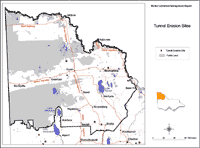 Mallee Tunnel Erosion |
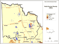
| Similarly, the spatial distribution of gully erosion in the region may have altered since the time that the map was constructed. The highest density of gullying was > 0.5 km/km2 on lunettes, with the rating classed as ‘low’ for the rest of the region. There was no apparent link between tunnel and gully erosion on these maps. Summary of Land Degradation in North-Western Victoria as reported by Rowan and Downes (1963) Different types of land degradation were found to have occurred in various land system components and these can be viewed in the original scanned document together with an outline of environmental characteristics (Rowan and Downes, 1963). A general discussion of the incidence and processes involved the land systems is located in the section on ‘Soil Conservation’ (pp. 106-109). | 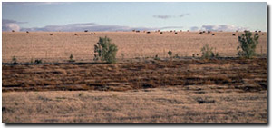 Salinity discharge at base of sand dunes near Hopetoun. |
A summary of these types of degradation for the entire land system is presented in the following table.
A Summary of Land Degradation in North-Western Victoria as reported by Rowan and Downes (1963).
| Land System | Main Forms of Land Degradation Listed |
| Central Mallee | Wind erosion, salt seepage, channel salting, drift, nutrient decline |
| Big Desert | Wind erosion, drift |
| Berrook | Wind erosion |
| Tempy | Wind erosion, salt seepage, channel salting, nutrient decline |
| Culgoa | Wind erosion, drift, nutrient decline |
| Hopetoun | Wind erosion, salt seepage, channel salting, dryland salting, scalding, surface sealing, nutrient decline |
| Tyrrell Creek | Wind erosion, drift, gully erosion on lunettes, scalding, flooding, surface sealing |
| Wycheproof | Soil structure decline |
| Boigbeat | Wind erosion |
| Raak | Wind and water erosion, seepage, saltpans |
| Millewa | Wind erosion, scalding, nutrient decline |
| Ned's Corner | Wind, rill and gully erosion, scalding, flooding, surface sealing, salting |
| Lindsay Island | Wind and water erosion, flooding |
Reference
Rowan, J.N. and Downes, R.G. (1963) ‘A study of the land in North-Western Victoria’. Soil Conservation Authority of Victoria Technical Communication No.2. (Government Printer, Melbourne)
© State of Victoria (Agriculture Victoria) 1996 - .

This work, Victorian Resources Online, is licensed under a Creative Commons Attribution 4.0 licence. You are free to re-use the work under that licence, on the condition that you credit the State of Victoria (Agriculture Victoria) as author, indicate if changes were made and comply with the other licence terms.
The licence does not apply to ‘branding’ or some ‘images or photographs’ that may be owned by third parties. We ask you to seek prior approval to use images using the VRO feedback form. Access to higher quality images can also be provided on request.
This page was last updated on .