
ESAS12c
Location: Patchewollock
Australian Soil Classification: Hypercalcic, Regolithic, Calcenic TENOSOL
General Landscape Description: Summit surface of a sand dune within the north-south ridge. Gently undulating rises. Relict lunette.
Site Description: Crest.
Geology: Neogene (Tertiary) sediments; (Quaternary) aeolian sediments (Woorinen Formation).
Land Use: Cereal cropping.
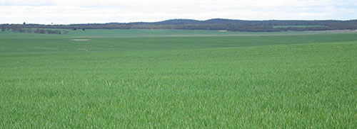
| ESAS12c Landscape |
Soil Profile Morphology:
Surface Soil
| Ap | 0-10 cm | Reddish brown (5YR4/4); light sand; loose surface condition; single grain (massive in wheel track); very weak consistence (moderately moist); pH 7.4; abrupt change to: | 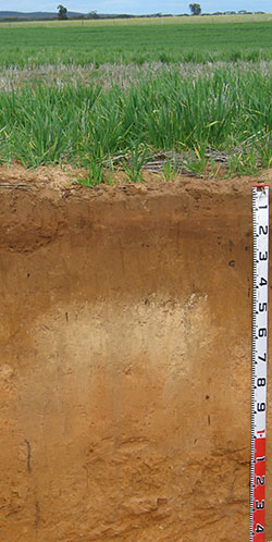 ESAS12c Profile ESAS12c Profile |
| A12 | 10-15 cm | Yellowish red (5YR4/6); light sand; single grain (massive in wheel track); very weak consistence (moderately moist); pH 6.4; abrupt change to: | |
| A13 | 15-22 cm | Reddish brown (5YR4/4); light sand; massive; very weak consistence (moderately moist); pH 7.3; clear change to: | |
| A14 | 22-45 cm | Reddish brown (5YR4/4); light sand; massive; very weak consistence (moderately moist); slightly calcareous; pH 8.7; abrupt, wavy change to: | |
| Subsoil | |||
| B21k | 45-80 cm | Strong brown (7.5YR5/6) and reddish yellow (7.5YR6/6 dry); clayey sand; weak coarse to fine angular angular blocky; very weak to weak consistence (moderately moist); very many (60%) soft and medium (6-20 mm) calcareous nodules; moderately calcareous; pH 8.8; gradual change to: | |
| B22k | 80-100 cm | Strong brown (7.5YR5/8); clayey sand; weak coarse to fine angular blocky structure; very weak consistence (moderately moist); highly calcareous; gradual change to: | |
| B23k | 100+ cm | Reddish yellow (7.5YR6/8) with many (20%) clear and distinct yellowish red (5YR5/8) mottles; clayey sand; weak coarse to medium blocky structure; top of layer silica sand (angular 30-80mm) capping; very firm to strong (dry) consistence; moderately to highly calcareous; pH 8.9. |
- Sandy profile throughout.
- Strongly alkaline subsoil.
- Some plant species may be impacted by boron toxicity in the subsoil.
Soil Profile Characteristics:
pH | Salinity Rating | |||
Surface (Ap horizon) | Slightly Alkaline | Low-Moderate | Non-Sodic | - |
Subsoil (B21 horizon) | Strongly Alkaline | Low | Non-Sodic | - |
Deeper Subsoil (at 100 cm) | Strongly Alkaline | Low | Non-Sodic | - |
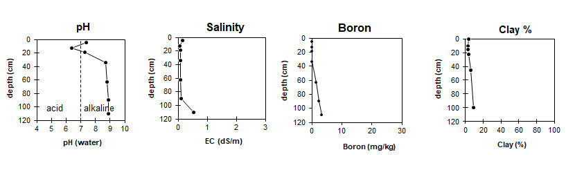
| The surface soil is slightly alkaline. The subsoil is strongly alkaline throughout. | The salinity rating is low to moderate in upper surface soil and low throughout the rest of the profile. | The was no boron detected in the surface soil. The upper subsoil has low boron levels becoming more toxic to plant roots at about 1 metres depth, depending on the plant species. | The clay content is low throughout the profile. |
Horizon | Horizon Depth (cm) | pH (water) | pH (CaCl2) | EC (dS/m) | Ca | Mg | K | Na |
meq/100g | ||||||||
Ap | 0 - 10 | 7.4 | 7.1 | 0.16 | 4.64 | 0.76 | 0.53 | 0.05 |
A12 | 10-15 | 6.4 | 6.0 | 0.05 | 1.91 | 0.42 | 0.39 | 0.03 |
A13 | 15 - 22 | 7.3 | 6.9 | 0.09 | 3.61 | 0.52 | 0.48 | 0.03 |
A14 | 22 - 45 | 8.7 | 8.1 | 0.08 | 14.27 | 0.76 | 0.42 | 0.04 |
B21k | 45 - 80 | 8.8 | 8.2 | 0.09 | 16.36 | 1.71 | 0.21 | 0.08 |
B22k | 80 - 100 | 8.9 | 8.3 | 0.10 | ||||
B23k | 100+ | 8.9 | 8.4 | 0.10 | 14.38 | 3.61 | 0.36 | 0.11 |
Horizon | Horizon Depth (cm) | Total Nitrogen % | Organic Carbon % | Available Boron mg/kg | Field Capacity pF2.5 | Wilting Point pF4.2 | Coarse Sand (0.2- 2.0 mm) | Fine Sand (0.02- 0.2 mm) | Silt (0.002- 0.02 mm) | Clay (<0.002 mm) |
Ap | 0 - 10 | 0.04 | 0.65 | 3.6 | 2 | 53 | 41 | 2 | 4 | |
A12 | 10-15 | 0.01 | 0.35 | 4.2 | 1.6 | 57 | 37 | 2 | 3 | |
A13 | 15 - 22 | 0.01 | 0.34 | 4.6 | 2 | 47 | 45 | 1 | 3 | |
A14 | 22 - 45 | 7.7 | 2.5 | 46 | 44 | 3 | 4 | |||
B21k | 45 - 80 | 1.54 | 10.1 | 4 | 48 | 39 | 5 | 6 | ||
B22k | 80 - 100 | 2.31 | 14.8 | 12.7 | ||||||
B23k | 100+ | 3.46 | 8.9 | 4 | 46 | 41 | 4 | 9 |
Profile Described By: Mark Imhof and Melissa Cann (August 2008).
© State of Victoria (Agriculture Victoria) 1996 - 2025.

This work, Victorian Resources Online, is licensed under a Creative Commons Attribution 4.0 licence. You are free to re-use the work under that licence, on the condition that you credit the State of Victoria (Agriculture Victoria) as author, indicate if changes were made and comply with the other licence terms.
The licence does not apply to ‘branding’ or some ‘images or photographs’ that may be owned by third parties. We ask you to seek prior approval to use images using the VRO feedback form. Access to higher quality images can also be provided on request.
This page was last updated on 26/11/2020.