ESAS12a
Location: Patchewollock
Australian Soil Classification: Mottled-Sodic, Supracalcic, Red KANDOSOL
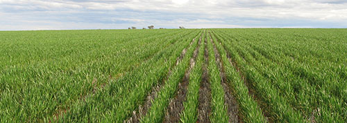
General Landscape Description: Sand dune within the north-south ridge. Gently undulating rises. Relict lunette.
Site Description: Lower mid slope.
Geology: Neogene (Tertiary) sediments; (Quaternary) aeolian sediments (Woorinen Formation).
Land Use: Cereal cropping.
 ESAS12a Landscape |
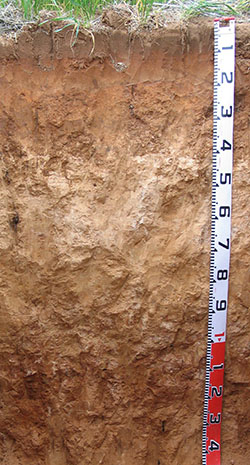
Soil Profile Morphology:
Surface Soil
| A11 | 0-10 cm | Brown (7.5YR4/3); light sand; loose surface condition; very weak (moist) consistence; pH 6.4; abrupt change to: |  |
| A12 | 10-17 cm | Yellowish red (5YR4/6); light sand; very weak (moist) consistence; moderate dispersion after remoulding; pH 6.6; abrupt change to: | |
| A13 | 17-20 cm | Strong brown (7.5YR5/6); light sand; loose (moist) consistence; pH 8.5; sharp change to: | |
| Subsoil | |||
| B21 | 20-30 cm | Yellowish red (5YR5/6); sandy loam; weak very coarse to coarse blocky structure; weak (moist) consistence; macropores present; roots along ped faces; strong dispersion after remoulding; pH 9.2; clear change to: | |
| B22k | 30-40 cm | Yellowish red (5YR5/6); sandy clay loam; very weak (moderately moist) consistence; many (20%) soft and semi-hard calcareous nodules; highly calcareous; pH 9.8; clear change to: | |
| B23k | 40-70 cm | Reddish yellow (7.5YR6/6); sandy clay loam; weak (moderately moist) consistence; very many (90%) calcareous nodules; highly calcareous; pH 9.9; gradual change to: | |
| B24k | 70-90 cm | Strong brown (7.5YR5/6); sandy loam; weak (moderately moist) consistence; very many (90%) calcareous nodules; highly calcareous; gradual change to: | |
| B25k | 90-120 cm | Strong brown (7.5YR4/6) with reddish yellow (5YR6/6) mottles; sandy loam; firm (moderately moist) consistence; few (5-10%) manganese flecks (2 mm) and many (50%) calcareous nodules; slightly calcareous; pH 9.7; gradual change to: | |
| B26k | 120+ cm | Yellowish red (5YR5/6); sandy clay loam; many (50%) calcareous nodules, moderately calcareous; pH 9.8. |
Key Profile Features:
- Sandy profile throughout.
- Strongly alkaline subsoil.
- Boron toxicity in the subsoil.
- Sodic subsoil becoming strongly sodic at depth.
Soil Profile Characteristics:
pH | Salinity Rating | |||
Surface (A11 horizon) | Slightly Acidic | Very Low | Non-Sodic | None1 |
Subsoil (B21 horizon) | Very Strongly Alkaline | Low-Moderate | Sodic | Moderate 2 |
Deeper Subsoil (at 100 cm) | Extremely Alkaline | High | Extremely Sodic | Strong |

| The surface is slightly acidic. The upper subsoil is very strongly alkaline becoming extremely alkaline at depth. | The salinity rating in the surface is very low. The upper subsoil is low to moderate. The salinity rating of the deeper subsoil is high. | The surface is non-sodic. The upper subsoil is sodic. The deeper subsoil is extremely sodic. | The clay content is low throughout the profile. | The boron content is low at the surface, increasing to extremely high at 1 metres depth. |
Horizon | Horizon Depth (cm) | pH (water) | pH (CaCl2) | EC (dS/m) | NaCl % | Ca | Mg | K | Na |
meq/100g | |||||||||
A11 | 0 - 10 | 6.4 | 5.6 | 0.04 | 1.97 | 0.55 | 0.66 | 0.07 | |
A12 | 10-20 | 6.6 | 5.6 | 0.03 | 2.60 | 0.82 | 0.52 | 0.12 | |
A13 | 20 - 30 | 8.5 | 7.7 | 0.11 | 6.08 | 2.70 | 0.78 | 0.93 | |
B21 | 30 - 40 | 9.2 | 8.3 | 0.23 | 18.51 | 4.60 | 0.85 | 2.25 | |
B22k | 40 - 70 | 9.8 | 8.8 | 0.45 | 24.14 | ||||
B23k | 70 - 90 | 9.9 | 9.0 | 0.51 | 10.19 | ||||
B24 | 90 - 120 | 9.7 | 9.0 | 0.53 | 20.77 | 2.01 | 3.32 | 1.56 | 5.35 |
B25 | 120+ | 9.8 | 8.6 | 0.51 | 9.91 | 1.80 | 2.89 | 1.39 | 4.54 |
Horizon | Horizon Depth (cm) | Total Nitrogen % | Organic Carbon % | Available Boron mg/kg | Field Capacity pF2.5 | Wilting Point pF4.2 | Coarse Sand (0.2- 2.0 mm) | Fine Sand (0.02- 0.2 mm) | Silt (0.002- 0.02 mm) | Clay (<0.002 mm) |
A11 | 0 - 10 | 0.03 | 0.41 | 6.7 | 2.1 | 68 | 25 | 1 | 2 | |
A12 | 10-20 | 0.01 | 0.16 | 6.4 | 2.2 | 56 | 34 | 1 | 7 | |
A13 | 20 - 30 | 0.01 | 0.29 | 1.36 | 17.3 | 6.9 | 43 | 34 | 5 | 14 |
B21 | 30 - 40 | 3.86 | 22.3 | 9.9 | 42 | 26 | 5 | 19 | ||
B22k | 40 - 70 | 9.28 | 20.5 | 8.3 | 45 | 22 | 4 | 16 | ||
B23k | 70 - 90 | 12.90 | 20.2 | 8.4 | ||||||
B24 | 90 - 120 | 21.46 | 22.7 | 9.9 | 51 | 27 | 2 | 10 | ||
B25 | 120+ |
Profile Described By: Mark Imhof and Melissa Cann (August 2008).


