
WP2
| Group: Birchip Cropping Demonstration Group | Australian Soil Classification: Calcic, Hypernatric, Brown SODOSOL |
| Northcote Factual Key: Db 1.13 | Great Soil Group: red brown earth |
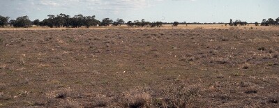 WP2 Landscape |
Soil Profile Morphology:
Surface Soil
| A11 | 0-10 cm | Dark brown (7.5YR4/2); sandy loam; hardsetting and massive; very strong consistence dry; pH 7.1; sharp change to: | 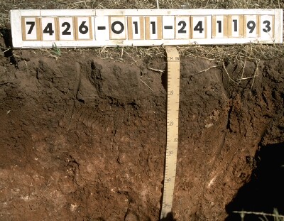 WP2 Profile |
| Subsoil | |||
| B21 | 10-30 cm | Dark brown (7.5YR4/4); medium clay; medium blocky structure; firm consistence moderately moist; contains a few (2-10%) soft carbonates; pH 8.7; gradual change to: | |
| B22k | 30-50 cm | Strong brown (7.5YR4/6); light medium clay; medium prismatic structure; firm consistence moderately moist; contains a few (2-10%) soft carbonates; pH 9.3; gradual change to: | |
| B23k | 50-70 cm | Strong brown (7.5YR5/6); medium clay; containing a few (2-10%) soft carbonate; pH 9.4; gradual change to: | |
| B31k | 70-110 cm | Pinkish grey (7.5YR7/2) with yellowish red (5YR5/8) mottles; medium heavy clay; prismatic structure; very strong consistence dry; contains a few (2-10%) soft carbonate; pH 9.3. | |
Key Profile Features:
Soil Profile Characteristics:
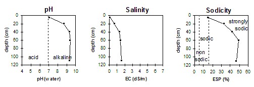
pH | Salinity | Sodicity | Dispersion | |
Surface (A1 horizon) | slightly alkaline | very low | sodic | - |
Subsoil (B21 horizon) | strongly alkaline | medium | strongly sodic | strong |
Deeper subsoil (at 1 m) | very strongly alkaline | high-very high | extremely sodic | none1 |
| 1 Due to a high level of soluble salts. | ||||
 |
Horizon | Horizon Depth (cm) | pH (water) | pH (CaCl2) | EC 1:5 | NaCl | Exchangeable Cations | |||
Ca | Mg | K | Na | ||||||
Meq/100g | |||||||||
A11 | 0-10 | 7.1 | 6.2 | 0.13 | 3.3 | 2 | 0.5 | 1 | |
B21 | 10-30 | 8.7 | 7.9 | 0.67 | 7.2 | 8.2 | 1 | 8.1 | |
B22k | 30-50 | 9.3 | 8.9 | 1.32 | 0.23 | 5.1 | 8.2 | 1.0 | 10.3 |
B23k | 50-70 | 9.4 | 8.8 | 1.49 | 0.26 | 4.5 | 9.2 | 1.1 | 14.1 |
B31k | 70-150 | 9.3 | 9 | 1.6 | 0.29 | 3.2 | 6.0 | 0.7 | 8.9 |
Horizon | Horizon Depth (cm) | Field Capacity pF2.5 | Wilting Point pF4.2 | Coarse Sand (0.2-2.0 mm) | Fine Sand (0.02-0.2 mm) | Silt (0.002-0.02 mm) | Clay (<0.002 mm) |
A11 | 0-10 | 9.9 | 6.6 | ||||
B21 | 10-30 | 46.1 | 24.8 | ||||
B22k | 30-50 | 42.5 | 23.3 | ||||
B23k | 50-70 | 38.2 | 15.5 | ||||
B31k | 70-150 |
Management Considerations
Surface (A) Horizon
- The hardsetting surface condition can be improved by using management practises such as minimum tillage, stubble retention and pasture rotations to improve organic matter levels. The level of organic carbon measured at the pit site (which may or may not be representative of the whole paddock) is quite low.
- The level of total nitrogen measured at the pit site is quite low. This is best assessed, however, by taking a bulked sample from across the paddock.
Subsoil (B) Horizons
- The upper subsoil is strongly sodic and dispersive. This will result in root and water movement being significantly restricted. Surface soil waterlogging is likely to occur in wetter periods as a result. The deeper subsoil below 30 cm depth becomes extremely sodic (and has a low exchangeable calcium to magnesium ratio) which will have a deleterious effect on soil structure.
- The level of soluble salts is medium in the upper subsoil (ie. 10-30 cm depth). This may affect the growth of salt sensitive species (eg. chick peas, lupins). The salinity rating becomes very high from 30 cm depth and the growth of a number of plant species (possibly including wheat, oats and barley) may be significantly restricted.
Comments from Landholder:
- Water lies on surface in wet years.
Profile Described By: Mark Imhof and John Martin (24/1/1993).
© State of Victoria (Agriculture Victoria) 1996 - 2025.

This work, Victorian Resources Online, is licensed under a Creative Commons Attribution 4.0 licence. You are free to re-use the work under that licence, on the condition that you credit the State of Victoria (Agriculture Victoria) as author, indicate if changes were made and comply with the other licence terms.
The licence does not apply to ‘branding’ or some ‘images or photographs’ that may be owned by third parties. We ask you to seek prior approval to use images using the VRO feedback form. Access to higher quality images can also be provided on request.
This page was last updated on 23/03/2020.