Your gateway to a wide range of natural resources information and associated maps

Victorian Resources Online

Goulburn

The 'Soils and Land Use in Part of the Goulburn Valley, Victoria' report was published by the Department of Agriculture in 1962 by J.K.M. Skene and T.J. Poutsma. This survey comprised the Rodney, Tongala-Stanhope, North Shepparton and South Shepparton Irrigation Areas. It is a detailed soil survey of some 223 000 hectares and was completed by a team of Department of Agriculture soil surveyors.

Soil maps derived from this report can be downloaded by clicking on to the appropriate sheet numbers on the map below. A downloadable version of the report (without the maps) is also available below.

A legend for the map will open in a new window automatically when a region is selected if you are using a Javascript enabled browser or access the legend here. A text list of links to the PDF maps is also available.

To view the information PDF requires the use of a PDF reader. This can be installed for free from the Adobe website (external link).
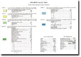
Goulburn

To soil map for sheet area 15 in PDF formatTo soil map for sheet area 16 in PDF formatTo soil map for sheet area 17 in PDF formatTo soil map for sheet area 18 in PDF formatTo soil map for sheet area 19 in PDF formatTo soil map for sheet area 20 in PDF formatTo soil map for sheet area 21 in PDF formatTo soil map for sheet area 26 in PDF formatTo soil map for sheet area 27 in PDF formatTo soil map for sheet area 28 in PDF formatTo soil map for sheet area 29 in PDF formatTo soil map for sheet area 30 in PDF formatTo soil map for sheet area 31 in PDF formatTo soil map for sheet area 32 in PDF formatTo soil map for sheet area 33 in PDF formatTo soil map for sheet area 38 in PDF formatTo soil map for sheet area 39 in PDF formatTo soil map for sheet area 40 in PDF formatTo soil map for sheet area 41 in PDF formatTo soil map for sheet area 42 in PDF formatTo soil map for sheet area 43 in PDF formatTo soil map for sheet area 44 in PDF formatTo soil map for sheet area 45 in PDF formatTo soil map for sheet area 49 in PDF formatTo soil map for sheet area 50 in PDF formatTo soil map for sheet area 51 in PDF formatTo soil map for sheet area 52 in PDF formatTo soil map for sheet area 53 in PDF formatTo soil map for sheet area 54 in PDF formatTo soil map for sheet area 55 in PDF formatTo soil map for sheet area 59 in PDF formatTo soil map for sheet area 60 in PDF formatTo soil map for sheet area 61 in PDF formatTo soil map for sheet area 62 in PDF formatTo soil map for sheet area 63 in PDF formatTo soil map for sheet area 64 in PDF formatTo soil map for sheet area 65 in PDF formatTo soil map for sheet area 67 in PDF formatTo soil map for sheet area 68 in PDF formatTo soil map for sheet area 69 in PDF formatTo soil map for sheet area 70 in PDF formatTo soil map for sheet area 71 in PDF formatTo soil map for sheet area 72 in PDF formatTo soil map for sheet area 73 in PDF formatTo soil map for sheet area 74 in PDF formatTo soil map for sheet area 75 in PDF formatTo soil map for sheet area 76 in PDF formatTo soil map for sheet area 77 in PDF formatTo soil map for sheet area 78 in PDF formatTo soil map for sheet area 79 in PDF formatTo soil map for sheet area 80 in PDF formatTo soil map for sheet area 81 in PDF formatTo soil map for sheet area 82 in PDF formatTo soil map for sheet area 83 in PDF formatTo soil map for sheet area 84 in PDF format

'Soils and Land Use in Part of the Goulburn Valley, Victoria' Report:


IMAGE: Goulburn Broken Soil and Land Use cover
Part 1
(pg 1 - 24)
goulburn_valley_p1.pdf
(PDF 1.5MB)
Part 2
(pg 25 - 40)
goulburn_valley_p2.pdf
(PDF 1.4MB)
Appendix Igoulburn_valley_a1.pdf
(PDF 278KB)
Appendix II, III & IVgoulburn_valley_a2.pdf
(PDF 198KB)
Page top