
Vertosols
Vertosols are often called cracking clay soils. They have clay texture throughout the profile, display strong cracking when dry as well as shrink and swell considerably during wetting and drying phases. In the Australian Soil Classification, Vertosols can be distinguished based on the nature of the surface horizon and the colour and chemical properties of the subsoil horizons. Based on the colour of the upper 50 cm of the soil profile, Vertosols can be grouped into various Suborders. Grey and Black Vertosols are the most common and can occur with Brown Vertosols.
| Vertosols in the Goulburn Broken Region The main soil characteristics of Vertosols are: clayey texture throughout; the surface soil is often a light clay (>35%) and the subsoil usually ranges from a light medium to a heavy clay. Due to the nature of the clay minerals these soils shrink and swell considerably during wetting and drying cycles. The soils crack significantly when dry and usually these will open up at the soil surface. Gilgai formation is often present (i.e. crabholey terrain). The soil profile is usually calcareous throughout and carbonate (lime) is usually present in the subsoil, often in large amounts. These soils are highly structured often with shiny polished surfaces with lense shaped peds (lenticular structure) that are formed with the movement of the clay. | 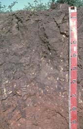 A grey Vertosol in the Dookie area. |
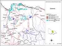 Vertosols in the Goulburn Broken Region |
This broad scale map presents an overview and should only be used as a general indication of the distribution of Vertosols in the Goulburn Broken Region. Soils are difficult to map at this broad scale because of their diversity. Even in relatively small areas, a number of soils may occur which relate to differences in topography and landscape position. Variation in some of the major soil profile properties can also occur within these mapped areas. Any agricultural enterprise should be based on a proper on-site assessment of the soil and landscape. |
| This map has been developed from work done by DPI's former Centre for Land Protection Research as part of the Goulburn Broken Dryland Regional Development Project. This work utilised existing surveys, remote sensing information and some additional field work to develop an updated 1:100 000 soil/landform coverage across the region. A number of soil surveys have been completed in this region at varying scales and intensity. However, in some areas very little soil survey has taken place (refer to the Soil and Land Survey Directory). | |
Vertosols are common in the northern parts of the Goulburn-Broken Region and often occur in association with other soil types. The main locations are either on low terrain on the plains including many swampy areas and on basic parent material (i.e. basalt, greenstone) such as the northern slopes of Mt. Major, around Dookie and north and west of Broadford.
There is incomplete knowledge at present of the differences between Vertosols in the region, apart from their colour (Suborder). Therefore differences based on surface structure i.e. self mulching or epipedal have yet to be formulated.

© The State of Victoria, 1996 - 2025.
This page was last updated on 23/03/2020.