
Rudosols
Rudosols, as the name suggests, have the least profile development of all soils. They are often just shallow soils with little more than some minor organic matter accumulation on the surface and weathered parent material. Due to the broad mapping scale used here, this soil type is likely to be under represented. However, it is mapped on the upper slopes of the Mt. Major complex and should be associated with other areas where rock outcrop is prevalent. Occurrences on unconsolidated material include some dune complexes in the Lake Cooper area and south of Cobram.
| Rudosols in the Goulburn Broken Region This broad scale map presents an overview and should only be used as a general indication of the distribution of Rudosols in the Goulburn Broken Region. It shows areas where Rudosols are most likely to occur within the region. Note that other soil types may also occur within these mapped areas (although they are likely to be a more minor component). This map has been developed from work done by DPI's former Centre for Land Protection Research as part of the Goulburn Broken Dryland Regional Development Project. This work utilised existing surveys, remote sensing information and some additional field work to develop an updated 1:100 000 soil/landform coverage across the region. | 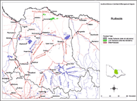 Rudosols in the Goulburn Broken Region |
Soils are difficult to map at this broad scale because of their diversity. Even in relatively small areas, a number of soils may occur which relate to differences in topography and landscape position. Variation in some of the major soil profile properties can also occur within these mapped areas. Any agricultural enterprise should be based on a proper on-site assessment of the soil and landscape. A number of soil surveys have been completed in this region at varying scales and intensity. However, in some areas very little soil survey has taken place (refer to the Soil and Land Survey Directory). | |

© The State of Victoria, 1996 - 2025.
This page was last updated on 23/03/2020.