
Kurosols
Kurosols are soils that display a strong texture contrast between surface (A) horizons and subsoil (B) horizons. The upper part of the subsoil is strongly acid (i.e. pH <5.5). Using the Australian Soil Classification, Kurosols can be grouped further (Suborder) based on the colour of the upper 20 cm of the subsoil (i.e. into Red, Brown, Yellow, Grey and Black). These can be further differentiated (into Great Groups) based on subsoil characteristics such as the nutrient level capacities and ratios.
Kurosols occur predominantly in the uplands where rainfall is higher and consequently so is the leaching. There are also minor occurrences north of Seymour. In the Goulburn Broken region, Red Kurosols occur at higher elevations and areas of higher rainfall, such as in the Strathbogie Ranges and south east of Alexandra. Yellow and Brown Kurosols occur mainly in the granite areas to the south of Euroa and to the east of Seymour.
| Kurosols in the Goulburn Broken Region This broad scale map presents an overview and should only be used as a general indication of the distribution of Kurosols in the Goulburn Broken Region. It shows areas where Kurosols are most likely to occur within the region. Note that other soil types may also occur within these mapped areas (although they are likely to be a more minor component). This map has been developed from work done by DPI's former Centre for Land Protection Research as part of the Goulburn Broken Dryland Regional Development Project. This work utilised existing surveys, remote sensing information and some additional field work to develop an updated 1:100 000 soil/landform coverage across the region. | 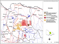 Kurosols in the Goulburn Broken Region |
| Soils are difficult to map at this broad scale because of their diversity. Even in relatively small areas, a number of soils may occur which relate to differences in topography and landscape position. Variation in some of the major soil profile properties can also occur within these mapped areas. Any agricultural enterprise should be based on a proper on-site assessment of the soil and landscape. A number of soil surveys have been completed in this region at varying scales and intensity. However, in some areas very little soil survey has taken place (see the Soil and Land Survey Directory). | |
Red Kurosols
Red Kurosols are found in the eastern Strathbogie Ranges, also east of the Strathbogie Ranges and probably an area south east of Alexandra at higher elevations. These soils tend to have strongly structured subsoils but a poor nutrient holding capacity given their high acidity. However, the surface horizons are often organic matter rich giving the medium textured soils structure which aids drainage. As with most red soils they tend to be whole coloured in the upper subsoil at least.
| Brown and Yellow Kurosols Brown and Yellow Kurosols are associated with granite areas south of Euroa and east of Seymour. These soils typically have a sandy loam to sandy clay loam surface horizon and a bleached subsurface (A2) horizon. These surface horizons overlie a light medium to medium clay strongly acid subsoil horizon. They are also associated with Tertiary gravel deposits north of Seymour. The surface horizons are sandy apart from an organic matter accumulation on the surface. The subsoil horizons are mottled and there are variable amounts of gravel within the main soil body (i.e. solum) as well as in the parent material. | 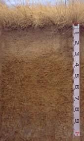 Yellow Kurosol near Ruffy |

© The State of Victoria, 1996 - 2025.
This page was last updated on 23/03/2020.