GL37 (8422) Wattle Point
|
This information has been developed from the publications:
|
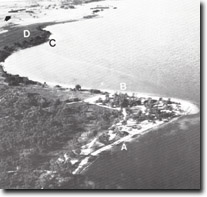
| Location: | 557968 (8422). Western shore of Lake Victoria. |  Cuspate foreland, Wattle Point. Eroded shoreline (A), Beach ridge shoreline (B), Tannin Point (C), Terrace (D), Degraded marginal bluff (arrowed). |
Abstract: | Cuspate foreland. | |
Access: | Wattle Point Road from Lower Goon Nure Road. | |
Ownership: | Partly Crown land, private land | |
Geomorphology:: | Wattle Point is a symmetrical cuspate foreland extending 150 metres into Lake Victoria and surrounded by sandy beaches with minor beach gravels. It is broadly similar in form to the other prominent spits on the Lake Victoria shoreline - Point Scott (GL-15), Point Turner (GL-23), Waddy Point (GL-38), and Storm Point (GL-39) - with several low sandy beach ridges on the eastern side and a generally eroding shoreline on the west. The foreland has built in front of a low bluff cut into an extension of the terrace described at Tannin Point (Gl-36), and has probably migrated slowly eastwards by the erosion of the western shore and the progradation of beach ridges on the east. Westerly winds are dominant over Lake Victoria and move sediment easterly along the northern shoreline. This is shaped into beach ridges and spits by wave refraction around the point of the foreland and by the less frequent easterly winds. | |
Significance: | Regional. Wattle Point differs from the other cuspate forelands on the north shore of Lake Victoria by being symmetrical in plan form. Beach ridge progradation on the eastern shoreline compares with the more general erosion conditions on Lake Victoria shores. | |
Management: | Before building erosion prevention structures on the western side of Wattle Point detailed investigation of their impact on local sediment transfer should be undertaken. Erosion on the western side of the point is a ‘normal’ process and is necessary to provide sediment for beach ridge progradation elsewhere. | |
| References: | Woodburn (1978). | |
 Sites GL 36-38 |


