GL15 (8422) Point Scott - Raymond Island
|
This information has been developed from the publications:
|
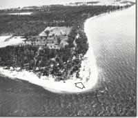
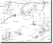
| Location: | 677036 (8422). South-eastern shoreline of Raymond Island. |  Cuspate foreland with parallel ridges (arrowed) at Point Scott - Raymond Island |
Abstract: | Cuspate foreland; prior barrier. | |
Access: | Boat from Paynesville. | |
Ownership: | Private land. | |
Geomorphology: | Point Scott is a cuspate foreland formed by the accretion of curving, parallel beach ridges consisting of sand with some gravels. The outermost ridges have distinct crests and swales, are closely spaced and of Holocene origin. Further inland, and to the west are low, broad, widely spaced ridges with well developed soil profiles indicative of a prior barrier (Pleistocene) age. The Holocene accretion ridges are best developed on the eastern side of Point Scott as a result of wave refraction around the apex of the foreland, whereas the western side typically shows erosion. | |
Significance: | Regional. The site illustrates the reshaping of the prior barrier topography by more recent shoreline accretion. | |
Management: | The maintenance of the site is dependent on continued movement of sediment eastwards along Raymond Island to nourish the accretion, ridges on the north-east of the point. Coastal engineering or harbour works which reduced this movement could lead to erosion of the ridges. | |


