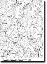
8523-19 The Pyramids Area
Sites 8523 (8522) 16 to 30 - The Buchan/Murrindal Limestone Basin
This information has been developed from the publications:
|
Location: | 072545. 6 kilometres north of Buchan adjacent to the Murrindal Reserve. | 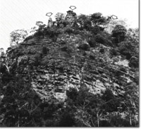 The Pyramids. Karren topography (arrowed). |
Abstract: | Contact between Buchan Caves Limestone and Snowy River Volcanics. Surface karst features and caves. | |
Access: | Pyramids Road south of Murrindal. | |
Ownership: | Crown land reserve and some private land. | |
Geology: | The contact between the Buchan Caves Limestone and the Snowy River Volcanics is extensively exposed in cliffs of the Murrindal River adjacent to, and south of the Pyramids. The best exposure of this contact occurs in Slaughter Camp Cliff, south of the Pyramids. Here a thin band of lithified tuff is overlain by a thin basalt flow rich in magnetite, which is in turn overlain by a thin basal grit and impure carbonate rocks at the base of the Buchan Caves Limestone. The limestone sequence at this locality is characterized by dolomotized sediments. Pure dolomite occurs approximately 1.3 m above the base of the Buchan Caves Limestone and is overlain by dolomitic limestone and then by limestone of very low dolomitic content. Buchan Caves Limestone is well exposed in cliffs at the Pyramids. In the lower sections of these cliffs the limestone is finely interbedded with mudstone while toward the top of the cliffed sequence it becomes more massive. These upper limestones are richly fossiliferous and contain ostracods, pelecypods and nautilooids. | |
Geomorphology: | Geomorphologically the area is significant as it portrays examples of undercut river drainage and an associated actively developing cave system together with surface karst features of note. Upstream from the Pyramids the Murrindal River has cut impressive cliffs in limestone up to 80 m in height on its western bank. These cliffs contain the entrances of several caves, the most notable of which are M-27, M-28 and M-29. These caves contain fossil bones of small native marsupials and rodents. Just to the north of the Pyramids, the total low level discharge of the Murrindal River disappears underground into the Pirana (M-82) - Dalley Sinkhole (M-35) - Sub-Aqua (M-26) Caves System. High discharges in the Murrindal River overflow around the east of the Pyramids where it has cut a channel in Snowy River Volcanics. Here the channel consists of large pools and coalesced potholes. In several areas small rapids and waterfalls occur, the largest of which is approximately 8 m in height. The Murrindal River enters the Pirana Cave (M-82) through a gravel choked sinkhole. This cave is estimated to be in excess of 100 m and consists mainly of a very tight stream passage with a few medium sized passage. Dalleys Sinkhole Cave (M-35) provides access to the middle sections of the underground course of the Murrindal River. Here a small dangerous entrance leads to an extensive cave system which is exceptionally well decorated. Here a canyon 20 m high and 10 m wide leads to a relatively large chamber which is backed by stream passages which end in a rockfall from which the river issues. High level passages occur and these rise to 40 m above the present river level. These passages and chambers are extensively decorated. The slopes and cliffs surrounding the Pyramids show excellent examples of travertine. In addition the hilltop at the Pyramids is cleared by a large chasm, 10 to15 m wide with cliffs on each side reaching 20 m in height. In all probability, this depression resulted from the collapse of caverns previously formed by the underground drainage of an older Murrindal River. The Pyramids themselves provide the best example of large scale karren topography in the Buchan area. They consist of three isolated stacks of bedded limestone separated by fissures up to 3 m deep. Many other cave systems occur in the designated area (e.g. over 30 recorded caves). The most notable of these if the Trogdip System (EB-10). This cave begins in a large entrance at the base of Slaughter Camp Cliff. This is an intermittent outflow cave consisting of low stream passage some 1400 m in length and a series of joint controlled fissures which include sections of excellent decoration. This cave is also notable for its bat chambers. | |
Significance: | National. The area provides the best example in Victoria of underground stream drainage and an associated active and well decorated cave system. In addition excellent example of karst features, particularly karren and travertine, occur. Good exposures of both Buchan Caves Limestone and Snowy River Volcanics, and the “transition beds” or Spring Creek Member occur at the site. | |
Management: | The general management prescriptions outlined are recommended for this area. It is emphasised that the surface karst features are fragile and the caves in this region are active and, because of the geological structure, highly unstable. Consequently, any land use which produces ground vibration would be detrimental to the maintenance of this cave system. Additionally, many of the caves contain bat colonies which may be destroyed by inappropriate land use. | |
References: | Kitson, A.E. 1907. 'Proposed reservation of limestone caves in the Buchan District, Eastern Gippland', Rec. geol. Surv. Vict., II(I) :37-44. Talent, J.A. 1955. Tiechert, C. and Talent, J.A. 1958. 'Geology of the Buchan area, East Gippsland', Mem. geol. Surv. Vict., 21: 1-56. Wakefield, N. 1960. 'Recent mammal bones in the Buchan District', Vic. Nat., 77(6) :164-178, 227-240. Matthews, P.G. (ed) 1968. Speleological Handbook. Victorian Speleological Association. Nicoll R.S. and Brush, J.B. 1976. Guidebook to the caves of South Eastern N.S.W. and Eastern Victoria. A.S.F. Guidebook No.1. White, N.J. and Davey, A. 1977. 'Pollution of Moons Cave, Buchan, Victoria : A Case Study in Cave Reserve Management', Proc. 11th Biennial Conference, Australian Speleological Federation. Canberra, 1976. | |
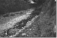 Murrindal. Stream sink (arrowed) of the Murrindal River near the Pyramids. | 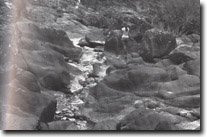 The Pyramids. Coalesced potholes in Snowy river Volcanics in the Murrindal river. |
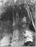 The Pyramids. Secondary deposition of travertine (kankar). | 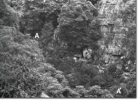 The pyramids. Collapsed cavern (A-A'). |

