
8523 (8522)-16 to 30 The Buchan/Murrindal Limestone Basin
|
This information has been developed from the publications:
|
Introduction: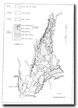 Geological map of the Buchan-Murrindal area. | Australia is relatively poorly endowed with limestone in outcrop and consequently has few karst landscape and cave areas. The outcrop of Devonian limestones in the Buchan area represent the largest outcrop of cave and karst-forming limestone in Eastern Australia, south of Chillagoe, Queensland. The Buchan - Murrindal basin is a “Karst barr”. (A Karst of limited area completely surrounded by rocks of low permeability.) Nevertheless, area contains the best examples of surface karst and cave development in Victoria. Despite this fact, there has been little scientific investigation of the geomorphology of the basin. In particular, insufficient work has been completed to establish the extent and quality of the caves and the hydrological associations of the cave systems. The inappropriate use of certain parts of cave systems, neglecting their interconnections, has resulted in the sewage pollution of Moon Cave (B-2), the degradation through the dumping of rubbish in Foul Air Cave (B-27) and Dickson’s Cave (M-30). The location of the Buchan rubbish tip in Tertiary sediments which may charge aquifers feeding the underground streams of the Buchan Caves Reserve, could result in pollution of the main tourist cave area. General Management Principles Our investigations are not of sufficient detail to allow complete management prescriptions to be formulated for each cave locality. We emphasise that any development that will cause surface or subsurface ground vibrations, or interfere with the air or water flow through caverns and passages, may degrade the cave resource. The scientific value of the cave areas will be diminished if: a. Infilling, or collapse of caves or blocking of cave entrances occurs; b. Cave decoration is destroyed through ground vibration, overuse or vandalism; c. Changes are made to the hydrological regime or quality of water entering the cave systems; d. The function of the caves as habitats for unique and important species of plants and animals is destroyed by changes in the above mentioned factors; e. The important archaeological and palaeontological deposits are destroyed the changes in the above mentioned factors. We stress that the management of Karst areas must avoid introducing the disturbances outlined above. Further detailed data about Karst features may be obtained from the Conservation Officer, Victorian Speleological Association, Box 5425cc, Melbourne. It is recommended that the Association be engaged as a consulting body when any change in the present status of Karst areas is contemplated. |
© State of Victoria (Agriculture Victoria) 1996 - 2025.

This work, Victorian Resources Online, is licensed under a Creative Commons Attribution 4.0 licence. You are free to re-use the work under that licence, on the condition that you credit the State of Victoria (Agriculture Victoria) as author, indicate if changes were made and comply with the other licence terms.
The licence does not apply to ‘branding’ or some ‘images or photographs’ that may be owned by third parties. We ask you to seek prior approval to use images using the VRO feedback form. Access to higher quality images can also be provided on request.
This page was last updated on 23/03/2020.