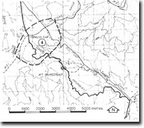
8423-4 Tongio Gap
|
This information has been developed from the publications:
|
Location: | 590880. 10 kilometres north-east of Omeo. | |
Abstract: | Low saddle in Great Dividing Range. | |
Access: | Omeo Highway. | |
Ownership: | Private land. | |
Geomorphology: | The main drainage divide of the Great Dividing Range exhibit’s a marked asymmetrical form, the south flowing stream valley profiles being steeper than those of the northerly flowing streams. This phenomenon is clearly displayed at Tongio Gap, a low saddle in the Great Dividing Range. It has been suggested that Tongio Gap together with Cassils Gap to the south were located on old courses of the Mitta Mitta, Cobungra and Victoria Rivers which originally flowed north into the Tambo River. These rivers were later captured by the headwaters of a north-flowing stream, changing the drainage characteristics and isolating Tongio Gap at the stream divide. | |
Significance: | Regional. The marked asymmetry of the divide is well displayed at Tongio Gap. | |
Management: | Because of the area covered by the site the value of the geomorphological features is unlikely to be seriously reduced by localized disturbance e.g. sand works, extractive industries or agriculture. | |
References: | Crohn, P.W. 1950. 'The geology, petrology and physiography of the Omeo District, North-Eastern Victoria', Proc. R. Soc. Vict., 62 :1-70. | |


