8423-18 Sandy Creek
|
This information has been developed from the publications:
|
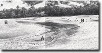
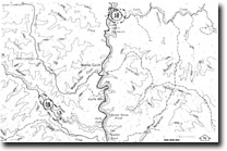
Location: | 520815 and 556768. Swifts Creek Valley and the township of Swifts Creek. |  Sandy Creek. Abandoned meander (A). Alluvial terrace (B). |
Abstract: | Exposures of knotted schist. Historical mining site. | |
Access: | Swifts Creek - Omeo Road. | |
Ownership: | Crown land (Road reserve). | |
Geology: | Fine exposures of cordierite knotted schists occur in road cuttings to the west of Cassilis (520815). These rocks are typical on the intermediate grade rocks occurring on the Omeo metamorphic complex. The Cassilis area was the centre of extensive gold mining activity early this century. The abandoned King Cassilis Mine (556768) is of particular interest in this context. | |
Significance: | Local. The road cuttings exposing the intermediate metamorphics is a clear and easily accessible example of this rock type. | |
Management: | Maintenance of clear faces in the road cuttings would enhance the significance of the site. Access to the King Cassilis Mine site should be maintained. | |
References: | Vandenberg, A.H.M., and O’Shea, P.J. 1980. 'Explanatory Notes on the Bairnsdale 1:250,000 geological map'. Rep. geol. Surv. Vict., No.65. | |

Sites 8423 18-19


