8423-1 Livingstone Creek
|
This information has been developed from the publications:
|
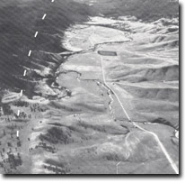
Location: | 535988 to 537040. Livingstone Creek Valley 5 kilometres north of Omeo. |  Topographic expression of the Livingstone Creek Fault. Dotted line indicates the approximate position of the fault terrace. |
Abstract: | Fault related drainage systems. | |
Access: | Omeo Highway. | |
Ownership: | Private land. | |
Geomorphology: | The Livingstone Creek Valley in this area is markedly asymmetrical in profile with elevated, steep and dissected western slopes contrasted with the undulating topography to the east. The valley asymmetry is attributed to Late Cainozoic uplift of the western side along Livingstone Creek. This movement rejuvenated the western tributaries of the creek and stimulated dissection of the fault scarp. Movements along the fault forced the diversion of Livingstone Creek to the east and the old course is now evidenced by several high level gravel deposits on the northern scarp. An extensive area of alluvium occurs at Hinnomunjie Swamp and this may have been deposited in a temporary lake formed as a result of stream disruption due to movements on the Livingstone Creek Fault. | |
Significance: | Regional. Fault scarp and fault related drainage characteristics are evident on a macro scale. | |
Management: | Because of the area covered by the site the value of the geomorphological features is unlikely to be seriously reduced by localized disturbance e.g. road works, extractive industries or agriculture. | |
References: | Crohn, P.W. 1950. 'The geology, petrology and physiography of the Omeo District, North-eastern Victoria', Proc. R. Soc. Vict., 62 :1-70. | |

Sites 8423 1-3


