
Delta (Da)
 | Area: 54 sq. km (0.3%) All major river levees and deltas associated with the Gippsland Lakes are included in this land system. Depositional tracts with significant levee construction begin where the form of the stream alters from sinuous to relatively straight or broadly curved, usually 10 to 15 km upstream from the point at which the river enters the lake. The deltas are mostly cuspidate and in varying stages of erosional decline, although the Mitchell River delta is digitate. The deltas are formed essentially by extensions of the natural levees. The combination of land components varies from stream to stream and with position along the stream. Component 3 is similar to lands in the Morass land system. | 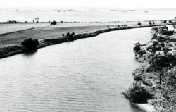 Elongated areas of low-lying land, bordered by rivers or lakes, are typical of the Delta land system. Land use is mostly grazing or water-based recreation. |
| Soils have developed on fine sand, silt and clay parent materials and are characteristically young. In some areas, sedimentation has been slow enough to allow topsoils to accumulate organic matter and develop a crumb or tine blocky structure. This condition is found largely in component 1. On many levees the surface sediments are too young to show any alteration by soil-forming processes. Erosion hazards are minor, but soil structure in component 1 is sensitive to damage by trampling or trafficking, particularly when the soils are wet. Salinity hazard is high, due to shallow water tables and moderate to high groundwater salinities. Prior to clearing, the vegetation was probably grassy open forest II with shrubby open forest II on river banks and closed scrub and sedgelands in swamps. River banks and swamps often have fringing stands of Phragmites | ||
| CLIMATE Rainfall, mean (mm) Temperature, mean (°C) Seasonal growth limitations | Annual 500 - 800; lowest July (30 - 50), highest October (50 - 80) Annual 12 - 14; lowest July (8 - 10). highest February (19 - 21) Temperature <10°C (av.): July Rainfall < potential evapotranspiration: November – March |
| GEOLOGY Age, lithology | Holocene alluvium of tine sands, silts and minor clays |
| PHYSIOGRAPHY Landscape Elevation range (m) Relative relief (m) Drainage pattern Drainage density (km/km2) | River levees and cuspate or digitate deltas in lacustrine environments 0 - 20 0 - 5 Deranged 1.3 |
| PRESENT LAND USE | Mostly cleared: grazing of beef and dairy cattle on improved pastures; cropping limited; some irrigation Minor proportion uncleared: recreation — fishing and shooting; some areas in The Heart Morass, Clydebank Morass, Dowd Morass and Lake Coleman State Game Reserves |
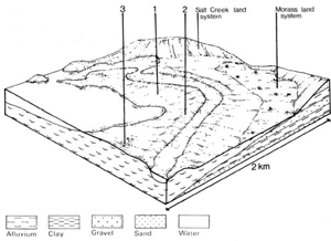 | 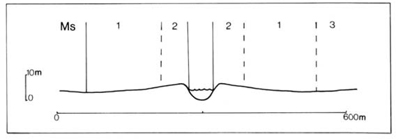 |
| LAND COMPONENT Percentage of land system Diagnostic features | 1 65 Levee slopes and deltaic plains | 2 20 Levee crests and river banks | 3 15 Estuarine swamps, freshwater and brackish |
| PHYSIOGRAPHY Slope %, typical and (range) Slope shape | 1, (0 - 2) Straight or concave | 2, (0 - 3) Convex | <1, (0 - 2) Straight |
| SOIL | |||
| Parent material | Fine sand, silt and clay | Fine sand, silt and clay | Fine sand, silt, clay and peat |
| Description | Limited observations — commonly black, fine structured silty loam to sandy clay loam or heavier textured topsoil merging into greyish brown mottled stratified subsoil | Dark greyish brown massive or fine structured sand to sandy clay loam topsoil merging into greyish brown or dark brown subsoil of variable texture; stratified at depth | No observations — soils presumed similar to Morass land system components 1, 2. and 3: variable texture, surficial or buried peaty layers, permanently wet |
| Classification | Wiesenboden Um6.21 | Alluvial Soils Uc1.44, Uc6.12, Um1.23, Um1.43, Um5.52 | Humic Gleys, some Acid Peats - |
| Surface texture | Silty loam or heavier texture | Sand to sandy clay loam | Organic silty loam probably common |
| Surface consistence | Slightly hard when dry, friable when moist | Loose to slightly hard when dry | Slightly plastic when wet |
| Depth (m) | >2.0 | >2.0 | >2.0 |
| Nutrient status | Moderate | Moderate | Moderate |
| Available soil water capacity | Moderate to high | Low to moderate | High |
| Perviousness to water | Slow | Moderate to rapid | Slow to moderate |
| Drainage | Poor to somewhat poor | Good | Very poor |
| Exposed stone (%) | 0 | 0 | 0 |
| Sampled profile number | 25 | 19 | - |
| NATIVE VEGETATION Structure of vegetation and characteristic species of dominant stratum (+ Predominant species) | Grassy open forest II: E. tereticornis+ Clearing has made it difficult to determine the species may also have been | Shrubby open forest II: Mainly E. tereticornis+; E. bosistoana or E. polyanthemos occasionally predominant. Phragmites communis often on river banks composition of the original vegetation; other predominant or associated | Vegetation variable, similar to Morass land system |
Disturbance | Affected process and trend | Primary resultant deterioration | Casual activities | Primary off-site process | ||
Form | Susceptibility of components | Incidence with components | ||||
— reduction in leaf area, rooting depth and/or perenniality |
resulting in: a) increased deep percolation b) rising, saline groundwater table |
|
|
|
|
|
|
|
Wave erosion |
2; moderate |
Common: severe on exposed lake shores |
Protection once afforded by Phragmites communis is reduced by increasing salinity of lake |
Increased lake turbidity |
|
With Reduced infiltration |
Sheet and rill erosion |
2; low 1,2; low |
Uncommon: occurs occasionally |
As for sheet and rill erosion above |
Increased run-on and/or ponding of water |
|
|
Streambank erosion Wave erosion |
2: high 2: moderate |
Common: partly a natural process Common: severe on exposed lake shores |
As for sheet and rill erosion above As for wave erosion above |
Increased sediment load and turbidity of streams Increased turbidity of lake water |
| ||||||
© State of Victoria (Agriculture Victoria) 1996 - 2025.

This work, Victorian Resources Online, is licensed under a Creative Commons Attribution 4.0 licence. You are free to re-use the work under that licence, on the condition that you credit the State of Victoria (Agriculture Victoria) as author, indicate if changes were made and comply with the other licence terms.
The licence does not apply to ‘branding’ or some ‘images or photographs’ that may be owned by third parties. We ask you to seek prior approval to use images using the VRO feedback form. Access to higher quality images can also be provided on request.
This page was last updated on 23/03/2020.