Morass (Ms)
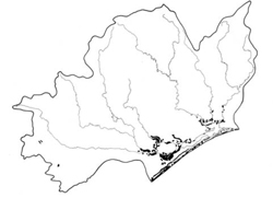
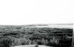
 | Area: 216 sq. km (1.1%) All small water bodies and major swamps on the lowlands are included in Morass land system where mapping scale permits. The great inherent variability is difficult to express in terms of land components which must cater for swampy areas in fluviatile, aeolian, lacustrine, littoral and paludal situations. The swamps may be permanent or ephemeral, with fresh or brackish water. Soil parent materials probably range from sand to clay. All areas are poorly drained and some may be permanently inundated. Soil development in the permanently inundated areas is almost negligible. Elsewhere the formation of organic-rich mineral horizons at the surface has usually occurred. The frequent sedimentation generally preventing the development of peats. Subsoils have undergone little alteration beyond the development of grey and olive yellow colours, and mottling. In areas with saline water, the reaction generally is alkaline but in other places the soils are often highly acidic. The erosion hazard is usually negligible except along shorelines and river banks which may be threatened by wave erosion or undercutting by flowing water. |  A swampy plain with a sedgeland community adjoining a large lagoon, typical of Morass land system. |
| Vegetation varies with degree of inundation and salinity. Swamps typically have a zonation of vegetation with herbfields and sedgelands in the centre, grading into closed scrub bordered by open forest I or II. Lagoon margins also usually have open sedgelands, closed scrub and open forests. Tall grassland of Phragmites communis sometimes occurs as well. | ||
| CLIMATE Rainfall, mean (mm) Temperature, mean (°C) Seasonal growth limitations |
Annual 500 - 800: lowest July (30 - 50), highest October (50 - 80) Annual 12 - 14; lowest July (9 - 10). highest February (19 - 20) Temperature <10°C (av.): No months Rainfall < potential evapotranspiration: November – March |
| GEOLOGY Age, lithology |
Holocene fluviatile, aeolian, lacustrine and littoral deposits of sands, silts and clays, now in paludal environments |
| PHYSIOGRAPHY Landscape Elevation range (m) Relative relief (m) Drainage pattern Drainage density (km/km2) |
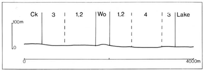
Swampy plains and water bodies 0 - 100 0 - 20 Undeveloped 0.2 |
| PRESENT LAND USE |
|
 |  |
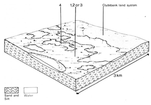
Percentage of land system Diagnostic features | 1 40 Freshwater swampy plains, sandy soils | 2 20 Brackish swampy plains, sandy soils | 3 20 | 4 20 Lagoons and marginal reed-swamps |
Slope %,typical and (range) Slope shape | <1, (0-2) Straight or slightly concave | <1, (0-2) Straight or slightly concave | <1, (0-2) Straight or slightly concave | 0, (-) Concave |
| ||||
| Sand, silt and clay of fluviatile, aeolian, lacustrine and littoral origin | |||
| Limited observations – black organic sandy loam topsoil grading into grey, olive yellow and brownish yellow mottled sandy subsoil; often more clayey substrata within a depth of 2 m | Dark sandy loam to silty clay loam topsoil, sometimes peaty subsoil; subsoil often stratified and including peat | No observations – thin brown topsoil of variable texture over grey stratified and variably textured sediments; no soils in permanently inundated areas | |
| Humic Gleys Uc1.22, Uc1.44 | Humic Gleys, some Acid Peats Variable; Um1.21, Um1.43; O | - | |
| Sandy loam | Sandy loam to silty clay loam | Variable texture | |
| Friable when moist | Plastic when wet | - | |
| >2.0 | >2.0 | >2.0 | |
| Low to moderate | Moderate | Moderate | |
| Moderate to high | Moderate to high | Not applicable | |
| Rapid | Slow to moderate | Slow | |
| Very poor to poor | Very poor to poor | Very poor to permanently waterlogged | |
| 0 | 0 | 0 | |
| - | - | - | |
Structure of vegetation and characteristic species of dominant stratum (+ Predominant species) | Zonation of vegetation with, from centre of swamps to drier ground. | The lagoon margins have open sedgelands of hydrophytes, closed scrub of Melaleuca spp., or, on drier fringes, open forest of E. ovata. Reed-swaps with tall grassland of phragmites communis | ||
Closed sedgeland: Cyperaceae (often Eleocharis sphacelata), Juncaceae Closed scrub: Melaleuca ericifolia or M. squarrosa Open forest I or II: E. ovata, E. tereticornis (drier areas) | Mainly herbfield: Salicornia spp. Sedgeland: Juncus maritimus or Ghania spp. Closed scrub: M. ericifolia | Structure and species as for component 1 | ||
Disturbance | Affected process and trend | Primary resultant deterioration | Casual activities | Primary off-site process | ||
Form | Susceptibility of components | Incidence with components | ||||
— reduction in leaf area, rooting depth and/or perenniality |
resulting in raised groundwater table |
|
|
|
in the catchment |
table |
|
|
|
|
|
marginal reed community |
|
|
With Reduced infiltration |
Ponding of water |
3; moderate 3: moderate |
Common |
Increased trafficking and cultivation, overgrazing, export of organic matter |
- |
|
|
|
|
|
|
|
| ||||||


