
Site SW27
| Location: Bostock Creek. | Australian Soil Classification: Vertic (& Ferric), Subnatric, Grey SODOSOL. |
| General Landscape Description: Grazing paddock (dairy). | Mapping Unit: Unit 113 (Maher and Martin, 1987). |
| Site Description: Lower slope within gently undulating hills. | Geology: Quaternary - Newer volcanics (scoria). |
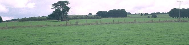 Site SW27 Landscape |
Soil Profile Morphology:
Surface Soil
| A11 | 0-15 cm | Black (10YR2/1); fine sandy clay loam; weak to moderate medium polyhedral, parting to moderate fine polyhedral structure; firm to very firm consistence (dry); weak-firm consistence (moist); pH 6.1; gradual change to: | 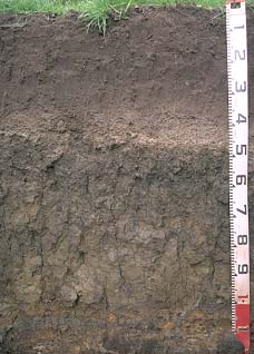 Site SW27 profile |
| A12 | 15-40 cm | Very dark grey (10YR3/1); fine sandy clay loam; moderate medium polyhedral, parting to moderate fine polyhedral structure; weak-firm consistence (moist); pH 5.8; abrupt change to: | |
| A2 | 40-50 cm | Brown (10YR5/3), conspicuously bleached (7.5YR7/2d); fine sandy clay loam; apedal; contains very many (> 50%) ferruginous nodules (2-6 mm in size); pH 6.5; sharp change to: | |
| Subsoil | |||
| B21 | 50-70 cm | Very dark greyish brown becoming dark greyish brown (2.5Y4/2) with depth, with yellowish brown (10YR5/6) mottles; heavy clay; moderate very coarse prismatic, parting to moderate coarse to medium polyhedral structure; strong consistence (dry); pH 6.5; gradual change to: | |
| B22 | 70-100 cm | Greyish brown (2.5Y5/2) with yellowish brown (10YR5/8) mottles; heavy clay; strong very coarse prismatic, parting to coarse prismatic and very coarse blocky structure; strong consistence (dry); many slickensides present; pH 7.0; abrupt change to: | |
| C | 100+ cm | Weathered ash. | |
Key Profile Features:
- Strong texture contrast between surface (A) horizons and subsoil (B21) horizon.
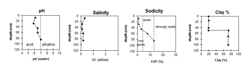
Key Profile Characteristics:
pH | Salinity Rating | ||
Surface (A1 horizon) | Slightly Acid | Low-Medium | Non-Sodic |
Subsoil (B21 horizon) | Slightly Acid | Low | Sodic |
Deeper subsoil (at 70-100 cm) | Neutral | Low | Sodic |
 |
Horizon | Horizon Depth (cm) | pH (water) | pH CaCl2 | EC 1:5 | NaCl % | Exchangeable Cations | |||
Ca | Mg | K | Na | ||||||
meq/100g | |||||||||
A11 | 0-15 | 6.1 | 5.7 | 0.29 | 0.02 | 14 | 2.3 | 0.6 | 0.1 |
A12 | 15-40 | 5.8 | 5 | 0.09 | 6.7 | 2.1 | 0.1 | 0.1 | |
A2 | 40-50 | 6.5 | 5.6 | 0.08 | 4.5 | 2.2 | <0.1 | 0.2 | |
B21 | 50-70 | 6.5 | 5.8 | 0.18 | 5.8 | 9.6 | 0.2 | 1.4 | |
B22 | 70-100 | 7 | 6.1 | 0.18 | 4.7 | 11 | 0.2 | 2.4 | |
C | 100+ | ||||||||
Horizon | Horizon Depth (cm) | Field Capacity pF2.5 | Wilting Point pF4.2 | Coarse Sand (0.2-2.0 mm) | Fine Sand (0.02-0.2 mm) | Silt (0.002-0.02 mm) | Clay (<0.002 mm) |
A11 | 0-15 | 39 | 18 | 6 | 39 | 22 | 19 |
A12 | 15-40 | 34 | 11 | 5 | 46 | 22 | 20 |
A2 | 40-50 | 26 | 11 | 29 | 33 | 15 | 19 |
B21 | 50-70 | 56 | 35 | 4 | 12 | 5 | 73 |
B22 | 70-100 | 26 | 32 | 3 | 14 | 8 | 72 |
C | 100+ |
Profile Described By: Mark Imhof and Austin Brown, August 1988.
© State of Victoria (Agriculture Victoria) 1996 - .

This work, Victorian Resources Online, is licensed under a Creative Commons Attribution 4.0 licence. You are free to re-use the work under that licence, on the condition that you credit the State of Victoria (Agriculture Victoria) as author, indicate if changes were made and comply with the other licence terms.
The licence does not apply to ‘branding’ or some ‘images or photographs’ that may be owned by third parties. We ask you to seek prior approval to use images using the VRO feedback form. Access to higher quality images can also be provided on request.
This page was last updated on .