
Site SW26
| Location: Camperdown. | Australian Soil Classification: Humose, Calcic, Black DERMOSOL (clayey). |
| General Landscape Description: Level plain. | Mapping Unit: Unit 2 (Maher and Martin, 1987). |
| Site Description: Grazing paddock (dairy). | Geology: Quaternary Newer volcanics (scoria). |
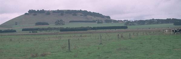 Site SW26 landscape |
Soil Profile Morphology:
Surface Soil
| A1 | 0-10 cm | Black (10YR2/1); light clay; strong medium polyhedral structure; very firm consistence dry; pH 6.7; clear change to: | 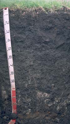 Site SW26 profile photo. |
| Subsoil | |||
| B21 | 10-30 cm | Very dark grey (7.5YR3/0); light clay; strong medium polyhedral, parting to strong fine blocky structure; firm consistence moist; pH 7.7; gradual change to: | |
| B22 | 30-60 cm | Very dark grey (10YR3/1); medium clay; strong medium blocky, parting to strong fine blocky structure; very firm consistence moist; pH 8.5; gradual change to: | |
| B23 | 60-100 cm | Very dark grey (10YR3/1); medium clay; strong medium blocky, parting to strong fine blocky structure; very firm consistence moist; contains a few (5-10 %) calcareous nodules and soft segregations; pH 8.8; gradual change to: | |
| B24 | 100-130 cm | Very dark grey (10YR3/1); medium clay; contains a common (20%) amount of calcareous nodules and soft segregations; pH 8.7; abrupt change to: | |
| C | 130+ cm | Volcanic ash deposits. | |
Key Profile Features:
- Clay texture throughout profile.
Key Profile Characteristics:
pH | Salinity Rating | |||
Surface (A1 horizon) | Slightly Acid | Moderate | Non-Sodic | None1 |
Subsoil (B21 horizon) | Slightly Alkaline | Moderate | Non-Sodic | Strong2 |
Deeper subsoil (at 1 m) | Strongly Alkaline | Moderate | Sodic | Moderate3 |
2. Complete dispersion after remoulding.
3. Strong dispersion after remoulding.
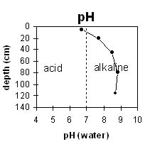 | 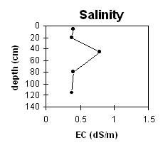 | |||||
The surface horizon is slightly acid. The upper subsoil is slightly alkaline becoming strongly alkaline at 80 cm depth. | The surface has a moderate salinity rating. The subsoil is high at 45 cm then decreases with depth. | |||||
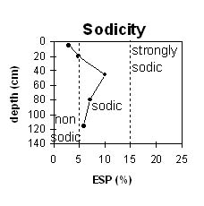 | 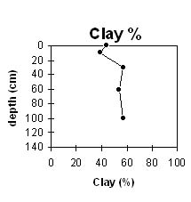 | |||||
The surface is non-sodic. The subsoil becomes sodic at 25-30 cm depth. | The clay content increases gradually down the profile. |
Horizon | Horizon Depth (cm) | pH (water) | pH CaCl2 | EC 1:5 | NaCl % | Exchangeable Cations | |||
Ca | Mg | K | Na | ||||||
meq/100g | |||||||||
A1 | 0-10 | 6.7 | 0.4 | 0.4 | 19 | 11 | 1.7 | 1 | |
B21 | 10-30 | 7.7 | 0.38 | 0.38 | 0.04 | 19 | 18 | 4.8 | 2.8 |
B22 | 30-60 | 8.5 | 0.79 | 0.79 | 0.09 | 16 | 21 | 6.8 | 4.7 |
B23 | 60-100 | 8.8 | 0.4 | 0.4 | 0.03 | 13 | 18 | 6.5 | 2.7 |
B24 | 100-130 | 8.7 | 0.37 | 0.37 | 0.02 | 13 | 16 | 5.4 | 2.3 |
C | 130+ | ||||||||
Horizon | Horizon Depth (cm) | Field Capacity pF2.5 | Wilting Point pF4.2 | Coarse Sand (0.2-2.0 mm) | Fine Sand (0.02-0.2 mm) | Silt (0.002-0.02 mm) | Clay (<0.002 mm) |
A1 | 0-10 | 63 | 37 | 8 | 15 | 17 | 44 |
B21 | 10-30 | 64 | 40 | 3 | 14 | 32 | 39 |
B22 | 30-60 | 70 | 43 | 1 | 7 | 24 | 57 |
B23 | 60-100 | 61 | 38 | 1 | 5 | 22 | 54 |
B24 | 100-130 | 0 | 34 | 1 | 6 | 10 | 57 |
C | 130+ |
Profile Described By: Mark Imhof and Austin Brown, August 1998.
© State of Victoria (Agriculture Victoria) 1996 - 2025.

This work, Victorian Resources Online, is licensed under a Creative Commons Attribution 4.0 licence. You are free to re-use the work under that licence, on the condition that you credit the State of Victoria (Agriculture Victoria) as author, indicate if changes were made and comply with the other licence terms.
The licence does not apply to ‘branding’ or some ‘images or photographs’ that may be owned by third parties. We ask you to seek prior approval to use images using the VRO feedback form. Access to higher quality images can also be provided on request.
This page was last updated on 23/03/2020.