Soil/Landform Unit 70
Landform Unit Description
Page top
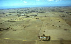 Barrabool Hills in the distance are pronounced as a dominant relief pattern over the neighbouring sedimentary and volcanic plains west of Geelong |
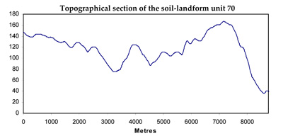
0.69% of CMA region Rolling hills with fertile soils to the west of Geelong lie mainly to the north of the present study area, but a small section forms the northern part of the catchment of Thompson Creek. These hills are on Lower Cretaceous sandstones and mudstones similar to those outcropping extensively in the Otway Range, but the landscape is more subdued and the rainfall is significantly lower. The original structure and species composition of the native vegetation are difficult to determine. The area has been extensively cleared for cropping and grazing and subdivided into somewhat smaller paddocks than the less fertile areas to the south. From the presence of isolated trees, Eucalyptus globulus and E. cypellocarpa formed part of the original vegetative community, and it is probable that E. radiata was also common. | 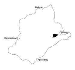 |
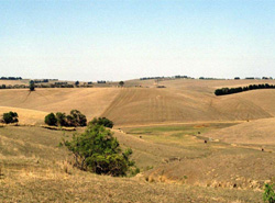 Hillslopes and valley floors are used mainly for cropping | 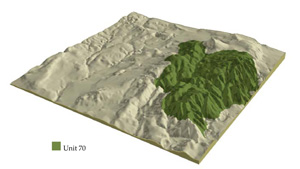 |
 | 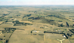 Extensively cleared rolling hills with windbreaks of radiata pine and cypress pine |
Component | 1 | 2 | 3 | 4 | 5 |
Proportion of soil-landform unit | 5% | 35% | 30% | 15% | 15% |
| CLIMATE Rainfall (mm) | Annual: 630 | ||||
| Temperature (oC) | Minimum 9, Maximum 19 | ||||
| Precipitation less than potential evapotranspiration | October-April | ||||
| GEOLOGY Age and lithology | Cretaceous fluvio-volcanic deposits, Paleogene and Neogene marine clay and silt, minor Quaternary basalt and alluvium | ||||
| Geomorphology | |||||
| LANDUSE | Uncleared: Nature conservation (including grassy woodland, floodplain riparian woodland and streambank shrubland) Cleared: Broadacre cropping (including cereals and pulses); sheep and cattle grazing | ||||
| TOPOGRAPHY Landscape | Rolling hills | ||||
| Elevation range (m) | 9-212 | ||||
| Local relief (m) | 150 | ||||
| Drainage pattern | Dendritic | ||||
| Drainage density (km/km2) | 2.0 | ||||
| Landform | Hills | Drainage line and valley floor | |||
| Landform element | Gentle crests | Undulating rises | Rolling hills | Dissected mid slopes | Drainage line/stream channel |
| Slope and range (%) | 4 (1-7) | 8 (3-15) | 12 (5-25) | 10 (5-20) | 4 (2-9) |
| Slope shape | Convex | Straight | Convex | Concave | Concave |
| NATIVE VEGETATION Structure | Woodland | Open forest | Open forest | Open forest | Open forest |
| Dominant species | E. ovata, E. viminalis | E. globulus, E. cypellocarpa | E. globulus, E. cypellocarpa | E. globulus, E. cypellocarpa | E. globulus, E. cypellocarpa |
| SOIL Parent material | Sandstone and mudstone | Sandstone and mudstone and colluvium | Sandstone and mudstone and colluvium | Sandstone and mudstone and colluvium | Sandstone and mudstone derived colluvium and alluvium |
| Description (Corangamite Soil Group) | Alkaline mottled brown and black texture contrast soils (5) | Alkaline mottled brown and black texture contrast soils (5) | Alkaline mottled brown and black texture contrast soils (5) | ||
| Soil type sites | |||||
| Surface texture | Fine sandy loam, clay loam | Fine sandy loam, clay loam | Fine sandy loam, clay loam | Fine sandy loam, clay loam | Fine sandy loam, clay loam |
| Permeability | Moderate | Moderate | Moderate to low | Low | Low |
| Depth (m) | <1.5 | <2 | <2 | <2 | >2 |
| LAND CHARACTERISTICS, POTENTIAL AND LIMITATIONS | Texture contrast, low water holding capacity and nutrient holding capacity in surface soil, possible sheet and rill erosion. Often sodic clay subsoil, hardsetting when dry. Moderately rapdi site drainage and better soil drainage. | Texture contrast, low water holding capacity and nutrient holding capacity in surface soil, possible sheet and rill erosion. Sodic clay subsoil, hardsetting when dry. Moderately rapid site drainage. | Texture contrast, low water holding capacity and nutrient holding capacity in surface soil, possible sheet and rill erosion. Sodic clay subsoil, hardsetting when dry. Rapid site drainage | Texture contrast, low water holding capacity and nutrient holding capacity in surface soil, possible sheet and rill erosion with slope. Sodic clay subsoil, hardsetting when dry. | Texture contrast, low to moderate water holding capacity and nutrient holding capacity in surface soil. Sodic clay subsoil, hardsetting when dry. Moderate to poor site drainage. |


