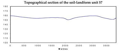
Soil/Landform Unit 57
Landform Unit Description
Page top
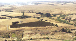 The entrenched valleys and slopes of the upper Moorabool River are prominent landforms of the dissected volcanic and sedimentary plains |
1.97% of CMA region Dissection of the lava plains, sediments and granites of the Western Uplands and plains of the Corangamite region has led to the development of dissected entrenched valleys with narrow to broad alluvial floors. This unique landscape includes the Moorabool River in the east and minor streams on the basalt plains in the west. The entrenched valley and valley floor supports the vegetation classes of Grassy Dry Forest, Valley Grassy Forest, Stream-bank Shrubland, Floodplain Riparian Woodland and Plains Grassy Woodland. Importantly the vegetation differs considerably from the Moorabool River to the basalt streams of the west. The main soil type of the unit is the black cracking clays with dark brown uniform soils of the alluvial plains. Terraces and lower slopes support yellow and brown texture contrast soils while the steep slopes and valley sides have black clays with some red gradational or texture contrast soils and some sandy areas (soils here can be quite variable depending on the host geology). Land use is quite variable and includes water supply, grazing, cropping, horticulture and nature conservation. Erosion hazards are high on the scarps and steep slopes, which have a high susceptibility to soil loss. Landslip and rock falls are also hazards of the steeper terrain. Areas with shallow soils are susceptible to leaching of nutrients, and compaction is a problem on the alluvial plains along with waterlogging and flooding in wet seasons. | 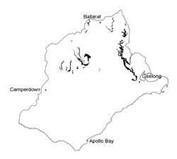 |
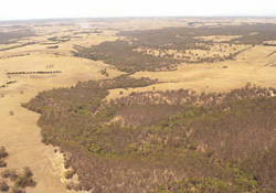 The vegetation differences reflect soil and water availability differences | 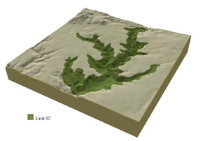 |
| 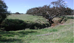 Minor streams of the basalt plains congregate in the upper catchment to eventuall drain into Lake Corangamite |
Component | 1 | 2 | 3 | 4 | 5 | 6 | 7 |
Proportion of soil-landform unit | 70% | 2% | 2% | 2% | 8% | 8% | 8% |
| CLIMATE Rainfall (mm) | Annual: 620 | ||||||
| Temperature (oC) | Minimum 8, Maximum 19 | ||||||
| Precipitation less than potential evapotranspiration | October-March | ||||||
| GEOLOGY Age and lithology | Quaternary; river deposits, gravels, sands and clays | ||||||
| Geomorphology | |||||||
| LANDUSE | Uncleared: Nature conservation; water supply Cleared: Sheep and beef cattle grazing; cropping | ||||||
| TOPOGRAPHY Landscape | Alluvial plain and valley sides | ||||||
| Elevation range (m) | 5-614 | ||||||
| Local relief (m) | 5-40 | ||||||
| Drainage pattern | Dendritic | ||||||
| Drainage density (km/km2) | 3.4 | ||||||
| Landform | Terraces | Valley sides | |||||
| Landform element | Terraces | Stony upper slopes or crest | Mid slope | Lower slopes | |||
| Slope and range (%) | 1 (1-2) | 1 (1-2) | 1 (1-2) | 2 (1-4) | 32 (20-60) | 25 (10-50) | 25 (10-50) |
| Slope shape | Straight | Straight | Straight | Straight | Convex to straight | Straight to concave | Straight to concave |
| NATIVE VEGETATION Ecological Vegetation Class | Grassy Dry Forest (3.6%), Valley Grassy Forest (1.9%), Stream-bank Shrubland (1.7%), Floodplain Riparian Woodland (1.3%), Plains Grassy Woodland (1.3%), and others (3.5%) | ||||||
| SOIL Parent material | Unconsolidated gravel, sand, silt and clay | Unconsolidated gravel, sand, silt and clay | Unconsolidated gravel, sand, silt and clay | Unconsolidated gravel, sand, silt and clay | In situ weathered basalt | In situ unconsolidated sediments and limestone, with colluvium from higher land. Some quartzite outcrops. | In situ slates and sandstone with colluvium |
| Description (Corangamite Soil Group) | Dark brown loam soils (variable) (34) | Yellow brown texture contrast soil (32) | Yellow brown texture contrast soil, coarse structure (32) | Brown, grey or yellow texture contrast soil (33) | Stony shallow brown clay soils (37) | ||
| Soil type sites | SW99, SW93, CLRA33 | ||||||
| Surface texture | Fine sandy clay loam | Sandy clay loam | Medium sandy clay loam | Clay loam | Clay loam | Mostly clay with some sandy rises | Fine sandy clay loam |
| Permeability | Moderate to low | Moderate to low | Moderate to low | Moderate to low | Moderate | Moderate | Moderate to low |
| Depth (m) | 2 | 2 | 2 | 2 | 0.1-0.5 | 0.3-0.2 | 0.3-1.0 |
| LAND CHARACTERISTICS, POTENTIAL AND LIMITATIONS | Low-lying areas receiving drainage are prone to waterlogging stream bank erosion. | Low permeability soils with weak surface structure. Hardsetting surfaces causes overland flow and erosion. Movement of salts occurs through subsurface flow. | Low permeability soils have weak surface structure topsoil that is hardsetting. Overland flow and subsurface flow concentrate movement of salts with waterlogging. Streambank and gully erosion occur with major flows. | Low permeability soils have weak surface structure topsoil that is hardsetting. Overland flow and subsurface flow concentrate movement of salts with waterlogging. Streambank and gully erosion occur with major flows. | Steep slopes and stream undercutting causes, slumping and rock falls. | Moderate to steep slopes with deep black clayey soils are of moderate slip hazard. Overland flows can cause rilling on exposed soil. | Moderate to steep slopes with deep black clayey soils are of moderate slip hazard. Overland flows can cause rilling on exposed soil. |

