
Soil/Landform Unit 189
Landform Unit Description
Page top
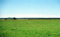 The near-level plains support a range of land uses including dairy. Most of the land has been cleared and replaced with annual and perennial pastures |
0.23% of CMA region This unit of near-level plains forms part of the sedimentary Western Plains. The unit comprises a series of sub-parallel occurrences in the Carpendeit area where they act as a divide between the stony rises (Unit 113) to the north and sandy (Neogene) sedimentary plains (Unit 181, Hanson Plain) to the south. Native vegetation is mainly Lowland Forest and Swamp Scrub. The soils are acidic mottled black texture contrast soils (Sodosols). Given the relatively high rainfall and topographic position, this unit is susceptible to waterlogging and compaction. Nutrient decline in the upper soil and structure decline (with increasing sodocity) are concerns. | 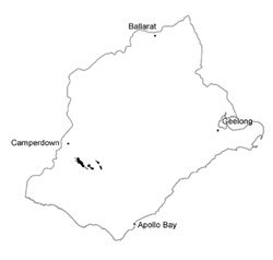 |
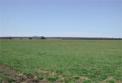 Looking north-west over the plains towards Mount Porndon | 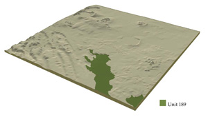 |
 |
Component | 1 | 2 | 3 |
Proportion of soil-landform unit | 30% | 65% | 5% |
| CLIMATE Rainfall (mm) | Annual: 830 | ||
| Temperature (oC) | Minimum 8, Maximum 18 | ||
| Precipitation less than potential evapotranspiration | November–March | ||
| GEOLOGY Age and lithology | |||
| Geomorphology | |||
| LANDUSE | Uncleared areas: Hardwood forestry for sawlogs, posts and poles; water supply; nature conservation Cleared areas: Dairy farming; sheep and beef cattle grazing; water supply; cropping | ||
| TOPOGRAPHY Landscape | Near-level plains | ||
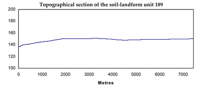
| Elevation range (m) | 127–153 | ||
| Local relief (m) | 15 | ||
| Drainage pattern | Centripetal–parallel | ||
| Drainage density (km/km2) | 1.0 | ||
| Landform | Plains | ||
| Landform element | Long gentle slopes | Level plain | Drainage depressions |
| Slope and range (%) | 2 (1–4) | 1 (0–3) | 0 (0–1) |
| Slope shape | Convex | Straight | Straight |
| NATIVE VEGETATION Ecological Vegetation Class | Lowland Forest (0.7%), Swamp Scrub (0.5%) | ||
| SOIL Parent material | Sand, clay and gravel | Sand, clay and gravel | Alluvium; clay, sand and gravel |
| Description (Corangamite Soil Group) | Acidic black texture contrast soils (14) | Acidic black texture contrast soils (14) | Acidic black and mottled black texture contrast soils (32) |
| Soil type sites | |||
| Surface texture | Clay loam | Clay loam | Sandy clay loam |
| Permeability | Low to moderate | Low | Very low |
| Depth (m) | <2 | <2 | >2 |
| LAND CHARACTERISTICS, POTENTIAL AND LIMITATIONS | Texture contrast, low nutrient holding capacity and water holding capacity in subsurface and surface soil, higher in subsoil. Acidic (not quite strongly). Heavy, possibly expansive clay subsoil. Moderate to slow site drainage. | Texture contrast, low nutrient holding capacity and water holding capacity in subsurface and surface soil, higher in subsoil. Acidic (not quite strongly). Heavy, possibly expansive clay subsoil. Slow site drainage, higher susceptibility to waterlogging and compaction compared with Component 1. | Texture contrast, low nutrient holding capacity and water holding capacity in subsurface and surface soil, higher in subsoil. Acidic (not quite strongly). Heavy, expansive clay subsoil. Slow to very slow site drainage, higher susceptibility to waterlogging and compaction compared with Components 1 and 2. |
© State of Victoria (Agriculture Victoria) 1996 - 2025.

This work, Victorian Resources Online, is licensed under a Creative Commons Attribution 4.0 licence. You are free to re-use the work under that licence, on the condition that you credit the State of Victoria (Agriculture Victoria) as author, indicate if changes were made and comply with the other licence terms.
The licence does not apply to ‘branding’ or some ‘images or photographs’ that may be owned by third parties. We ask you to seek prior approval to use images using the VRO feedback form. Access to higher quality images can also be provided on request.
This page was last updated on 23/03/2020.