Soils on Quaternary Unconsolidated Sediments
Qab - Terraces with Uniform Texture Soils on Holocene Sediments | Qaf - Fan-plain with mixed Uniform and Duplex Soils on Quaternary Sediments | Qah - Terraces with Duplex and Variable Uniform Texture Soils Quaternary Alluvium | Qao - Plains with Duplex Soils on Quaternary, or Older Sediments | Qau - Higher Terraces with Duplex Soils on Quaternary and Ordovician Sediments | Qde - Depressions with Heavy Clay Soils on Recent Sediments | Qded - Depressions with Heavy Clay Soils on recent sediments drier than Qde | Qsm - Valley floor with Uniform and Duplex Soils on Mixed Parent Materials | Qu - Lakeside Sandridge with Uniform Sand Soils on Recent Wind Blown Deposits | Qya - Terraces with Variable Soils on Quaternary Sediments | Qyad - Terraces with Variable Soils on Quaternary Sediments. Drier than Qya
Qya - Terraces with Variable Soils on Quaternary Sediments
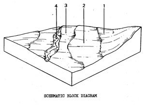 | River deposits of gravels, sands, silts, and clays along the main streams in the north of the Shire. The unit occupies 0.6% of the Shire and covers 4.4 km2. The unit is variable. Three different terraces are recognized though these do not occur in a repeated pattern and one or more may be absent at any given site. The oldest terrace has the greatest soil profile differentiation, the youngest the least. Salting may occur in some areas, the salt having been transported by ground-water from the surrounding Tertiary and Ordovician sediments. The unit is mainly used for grazing, with occasional fodder crops. Waterlogging and flooding hazard limit other uses. SOILS The soils of Component 2 (the most common component) are extremely variable, ranging from sands to clays. They are usually dark Um soils (clay loams and loams). As no meaningful soil description can be given at this scale, the description that follows is for duplex soils of a higher terrace. |
Factual Key: Dy 3.42/CL, 15-40 am/recent alluvium, 70-150 cm
Horizon | Depth (cm) | Description |
A1 | 0-10 | Dark brown (10YR 3/4) when moist; clay loam; apedal and massive; consistence when slightly moist is friable; pH 6.8; clear boundary. |
A21 | 10-20 | Dull yellowish brown (10YR 5/3) when moist; sandy clay loam; apedal and massive; consistence when slightly moist is friable; pH 6.3; diffuse boundary. |
A22 | 20-25 | Gravelly layer. |
B | 25-100 | Bright yellowish brown (10YR 6/8) when moist; with abundant distinct red mottles; medium clay; strong angular blocky 40 mm breaking down to =angular blocky 2 mm; consistence when slightly moist is firm; pH 5.3. |
C | 100+ | Alluvial deposits - stratified clays, sands and gravels. |
| COMPONENT Proportion % | 1 30 | 2 50 | 3 5 | 4 15 |
| CLIMATE | ||||
| Rainfall(av.) mm | Annual1600 - 680 | |||
| Temperature(av.) °C | Annual 12 | |||
| TOPOGRAPHY | ||||
| Landscape | Alluvium of the northern creeks in the Shire | |||
| Elevation (range) m | 240 - 360 | |||
| Local relief (av.) m | 5 | |||
| Drainage pattern | - | |||
| Drainage density km/km2 | 5.7 | |||
| Land form | Terraces | Stream channel | ||
| Position on land form | Higher terraces | Middle terrace | Lowest terrace | Stream bed and banks |
| Slope (range) %, slope shape | 1-5 ; Straight | 0-2 ; Straight | 0-2 ; Straight | - |
| NATIVE VEGETATION | ||||
| Structure | Woodland (?) | |||
| Dominant species | E. viminalis, E. radiata, some E. camaldulensis | |||
| SOIL | ||||
| Parent material | Unconsolidated river deposits | |||
| Description | Mottled yellow duplex soils | Dark uniform soils (variable texture-mainly clay loams) | Uniform (variable) sands through to clay | Variable-from clayey to stony material |
| Factual key | Dy 3.42 | Um 5.52 and others | ||
| Surface texture | Clay loam | Clay loam | Variable | - |
| Permeability | Moderate - low | Moderate - low | Variable | - |
| Depth (range) m | 1.2 - 2.0 | 1.2 - 2.0 | 0.5 - 1.0 | - |
| LAND USE | ||||
Grazing | Grazing, some market gardens on larger areas | Grazing, recreation | ||
| SOIL DETERIORATION | ||||
| Critical land features | Hard setting surfaces | Low lying areas prone to flooding | Exposed surfaces | |
| Processes | Overland flow | Overland flow, periodic waterlogging | Some accumulation of salts. Undercutting by stream, periodic waterlogging, overland flow | |
| Forms | Minor sheet erosion | Siltation | Streambank erosion, salting, flooding | |
Qab - Terraces with Uniform Texture Soils on Holocene Sediments
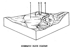 | Alluvial flats and terraces associated with the Moorabool River, south of Maude. They have an area of 9 km2 or 1.3% of the Shire. The most common soil is the dark, uniform, heavy textured soil which is found on the middle terrace. In some areas there are higher, sloping terraces which have red duplex soils, The middle terrace contains billabongs which are old river channels that were cut off when the river changed its course in the past. Components 3 & 4 and much of Component 2 are subject to flooding, but the frequency and intensity of flooding is variable. The middle and higher terraces are used for market gardening. SOILS The main soil type is found on Component 2. |
Dark Uniform Soils of Medium or Heavy Texture
Factual Key: Ug 5.1/CL-MC, 5-20 cm/alluvium, 100-200 cm
Horizon | Depth (cm) | Description |
A | 0-60 | Brownish black (10YR 3/1) when moist, with grey mottles; medium clay; moderate subangular blocky 5 mm; consistence when moist is firm; pH 6.5; clear boundary. |
B | 60-80+ | Black (10YR 2/1) when moist with yellow mottles; medium clay; strong angular blocky 4mm: consistence when moist is firm; pH 8.0. |
| COMPONENT Proportion % | 1 6 | 2 80 | 3 4 | 4 10 |
| CLIMATE | ||||
| Rainfall(av.) mm | Annual 500 - 610 | |||
| Temperature(av.) °C | Annual 13 | |||
| GEOLOGY | ||||
| Age, rock | Holocene river alluvium | Miocene sediments ? | ||
| TOPOGRAPHY | ||||
| Landscape | Terraces and flood plains along the Moorabool hills | |||
| Elevation (range) m | 30 - 122 | |||
| Local relief (av.) m | 14 | |||
| Drainage pattern | Dendritic | |||
| Drainage density km/km2 | 4.3 | |||
| Land form | Higher terrace | Middle terrace and billabongs | River channel and terrace | |
| Position on land form | Gentle upper slopes | Terrace | Billabong | Bottom |
| Slope (range) %, slope shape | 1-6 ; Convex | 1-2 ; Straight | 1-2 ; Concave | 1-2 ; Straight |
| NATIVE VEGETATION | ||||
| Structure | Open woodland | |||
| Dominant species | E. camaldulensis | |||
| SOIL | ||||
| Parent material | Unconsolidated materials | |||
| Description | Red duplex soils | Dark uniform soils of medium or heavy texture | Dark gradational soils | Uniform soils (variable) |
| Factual key | Dr 2.1 | Um / Uf | Gn 3.51 | Uc |
| Surface texture | Fine sandy loam | Clay loam | Clay loam | Silty clay loam (variable) |
| Permeability | Moderate | Moderate-high | Low | - |
| Depth (range) m | 1.0 - 2.0 | 1.0 - 2.0 | 0.8 - 1.2 | - |
| LAND USE | ||||
Some farm houses | Cultivation (Market garden) | Water supply, wild life conservation, recreation | ||
| SOIL DETERIORATION | ||||
| Critical land features | Hard setting surfaces | Low situation affected by flooding from river | ||
| Processes | Overland flow | Overland flow, periodic waterlogging | Sub-surface flow, overland flow, periodic waterlogging | Overland flow |
| Forms | Very minor sheet erosion | Siltation | Siltation | Stream-bank erosion |
Qaf - Fan-plain with mixed Uniform and Duplex Soils on Quaternary Sediments
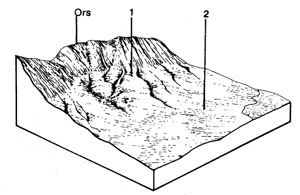 | Colluvial and alluvial outwash from the scarp of the Rowsley Fault along the eastern boundary at the northern end of the Shire. The total area of the unit is 4.2 km2, which represents 0.6% of the Shire. The soils of the upper steeper, slope strongly reflect the geology of the Rowsley Scarp. In most cases this is mainly basalt and the soils are dark brown uniform or dark duplex soils. Further south, where limestone forms the scarp, alkaline red mottled yellow duplex soils occur. The lower, gentler, slopes being formed on a mix of colluvium and alluvium do not reflect the geology of the scarp as strongly and generally have red duplex and occasionally red mottled yellow, duplex soils. The main land use is cropping and grazing. Gully erosion can be very severe in these soils, because the deep sodic deposits are subject to high-velocity flowing water from the escarpment. |
The soils on this unit are quite variable. The following description represents one of the more common soils of Component 1.
Dark Brown Shallow Uniform Clayey Soils - Weak Structure
Factual Key: Ug 5.3/CL -LMC, 10-20 cm/colluvium of basalt origin, 40-100 cm
Horizon | Depth (cm) | Description |
A | 0-15 | Dark brown (10YR 3/3) when moist; self-mulching medium clay; moderate angular blocky 5 mm; consistence when moist is firm and very plastic when wet; pH 6.5; clear boundary. |
B | 15-50 | Brown (7.5YR 4/4) when moist; clay; weak subangular blocky 5 mm; consistence when moist is hard; 20% lime as soft accumulations; pH 8.5. |
| COMPONENT Proportion % | 1 60 | 2 40 |
| CLIMATE | ||
| Rainfall(av.) mm | Annual 500 - 560 | |
| Temperature(av.) °C | Annual 12 | |
| GEOLOGY | ||
| Age, rock | Quaternary fault aprons, gravel, sand and clay | |
| TOPOGRAPHY | ||
| Landscape | Gently sloping plain below the Rowsley Fault scarp | |
| Elevation (range) m | 240 | |
| Local relief (av.) m | 7 | |
| Drainage pattern | Parallel | |
| Drainage density km/km2 | 1.2 | |
| Land form | Plain | |
| Position on land form | Upper slope | Lower slope |
| Slope (range) %, slope shape | 2 – 6 | l-3 |
| NATIVE VEGETATION | ||
| Structure | Open forest | |
| Dominant species | E. microcarpa, E. leucoxylon E. polyanthemos, E. goniocalyx | E, microcarpa, E. leucoxylon E. polyanthemos, E. goniocalyx E. ovata |
| SOIL | ||
| Parent material | Unconsolidated sediments | |
| Description | Dark brown shallow uniform soils, weak structure | Red duplex soils, coarse structure, sodic |
| Factual key | Ug 5.31 | Dr 3.23 |
| Surface texture | Light clay to clay loam | Clay loam |
| Permeability | Low | Clay loam |
| Depth (range) m | 0.4 - 1.0 | 1.5 - 2.5 |
| LAND USE | ||
Grazing, some cereal cropping | ||
| SOIL DETERIORATION | ||
| Critical land features | Poor soil structure, sodic soils - dispersibility, low permeability, long elopes | |
| Processes | Overland flow, sub-surface flow, movement of salts | |
| Forms | Moderate sheet, rill, gully and tunnel erosion | |
Qde - Depressions with Heavy Clay Soils on Recent Sediments
 | Swamps and depressions mainly in the northern part of the Shire. The total of only 1.0 km2, represents 0.1% of the Shire. The tendency of the land to be waterlogged or flooded, particularly in winter, limits its usefulness for anything more intensive than grazing. SOILS The soils are usually dark, with a high content of organic matter at the surface. Almost all of these depressions occur with the Tgn and the soils have a higher sand content in the topsoil than the Qde depressions in the basalt to the south. The following is a common soil. |
Factual Key: Dg 2.41/organic loam, 25 cm/unconsolidated sediments 100+ cm. 01 N
Horizon | Depth (cm) | Description |
0 | 0-10 | Brownish black (10YR 2/2) when moist; organic loam; moderate subangular blocky 3 mm; consistence when wet is "spongy" non plastic; pH 5.5; clear boundary. |
A1 | 10-25 | Brownish black (2.5YR 3/1) when moist; loam; weak subangular blocky 3 mm; consistence when wet is slightly plastic; pH 6.5; clear boundary. |
A2 | 25-45 | Dark greyish yellow (2.5YR 4/2) when moist with coarse yellow mottles; fine sandy loam; apedal and massive; consistence when wet is slightly plastic and "spewy"; pH 7.0; clear boundary. |
B | 45-100+ | Dark greyish yellow (2.5YR 4/2) when moist with yellow mottles; medium clay; moderate angular blocky 3 mm (possibly a coarse primary structure exists also); consistence when wet is plastic; pH 6.5. |
| COMPONENT Proportion % | 1 100 |
| CLIMATE | |
| Rainfall(av.) mm | Annual 585 - 635 |
| Temperature(av.) °C | Annual 12 |
| GEOLOGY | |
| Age, rock | Recent sands, silts and clays |
| TOPOGRAPHY | |
| Landscape | Swamps and depressions in northern, wetter parts of the area |
| Elevation (range) m | 240 - 565 |
| Local relief (av.) m | 1 |
| Drainage pattern | - |
| Drainage density km/km2 | - |
| Land form | Swamps and depressions |
| Slope (range) %, slope shape | 0-2; Flat |
| NATIVE VEGETATION | |
| Structure | Sedgeland |
| Dominant species | Lepidosperma longitudinale |
| SOIL | |
| Parent material | Unconsolidated sands, silts and clays |
| Description | Mottled grey duplex soils |
| Factual key | Gn or Ug |
| Surface texture | Light clay/clay |
| Permeability | Low |
| Depth (range) m | 1.0 - 2.5 |
| LAND USE | |
Grazing, occasional cropping (cereal) | |
| SOIL DETERIORATION | |
| Critical land features | Slowly permeable soils, seasonal high watertables |
| Processes | Periodic waterlogging |
| Forms | Surface compaction |
Qu - Lakeside Sandridge with Uniform Sand Soils on Recent Wind Blown Deposits
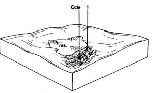 | Lakeside sandridges associated with Qde and Res, in the north of the Shire (Durdidwarrah Area). This unit covers 0.312 km2, representing 0.04% of the survey area. The Reservoirs (Res) are considered to have been larger areas of Qde which were converted to water storage. The areas of Qde, including those now Res, are presumably the source of sand for these sandridges which have built up on their south-eastern side. Where areas of Qde are surrounded by sand, the depressions are regarded as secondary, having formed subsequent to the deposition of the sand from a larger associated depression. These secondary depressions probably indicate further wind movement of the sand after initial deposition. SOILS The soil parent material is sand, producing a deep uniform profile. These soils are free drained and their fertility is low. If exposed they can be wind eroded. The colour of the deep sands may be reddish or yellowish. |
Factual Key: Uc 2.21/sand; 10-25 cm/loose sand; 70 cm
Horizon | Depth (cm) | Description |
A1 | 0-7 | Brownish grey (101R 4/1) when moist; sand; apedal single-grained; consistence when dry is soft; pH 6.0; clear boundary. |
A2 | 7-25 | Greyish yellow brown (10YR 5/2) when moist (10YR 7/1) when dry); sand; apedal singlegrained;' consistence when dry is soft; pH 5.5; diffuse boundary. |
B1 | 25-45 | Dull orange (7.5YR 6/4) when moist; sand; apedal single-grained; consistence when dry is soft; pH 6.0; diffuse boundary. |
B2 | 45-70 | Dull reddish brown (5YR 5/4) when moist; sand; apedal single-grained; consistence when dry is slightly hard; pH 5.5; diffuse boundary. |
C | 70-170 | Bright brown (7.5YR 5/6) when moist; sand; apedal single-grained; consistence when dry is soft; pH 6.0; abrupt boundary. |
D | 170-200+ | Buried clay similar to Tgn. |
| COMPONENT Proportion % | 1 100 |
| CLIMATE | |
| Rainfall(av.) mm | Annual 600 - 630 |
| Temperature(av.) °C | Annual 12 |
| GEOLOGY | |
| Age, rock | Recent, sands |
| TOPOGRAPHY | |
| Landscape | 'Lakeside sandridges' to the north of the Shire (Durdidwarrah Area) |
| Elevation (range) m | 350 - 365 |
| Local relief (av.) m | 1 - 2 |
| Drainage pattern | - |
| Drainage density km/km2 | |
| Land form | Lakeside sandridges |
| Position on land form | - |
| Slope (range) %, slope shape | 1 - 3 Convex |
| NATIVE VEGETATION | |
| Structure | Open Forest |
| Dominant species | E. viminalis, A. melonoxylon, A. mearnsii, Banksia marginata, Pteridium esculentum |
| SOIL | |
| Parent material | Unconsolidated sand |
| Description | Yellow sand soils, uniform texture |
| Factual key | Uc2 |
| Surface texture | Sand |
| Permeability | High |
| Depth (range) m | 1 - 2 |
| LAND USE | |
Grazing, Forestry, Water Supply | |
| SOIL DETERIORATION | |
| Critical land features | Low water holding capacity; Low nutrient holding capacity |
| Processes | Leaching |
| Forms | Fertility Decline |
Qah - Terraces with Duplex and Variable Uniform Texture Soils Quaternary Alluvium
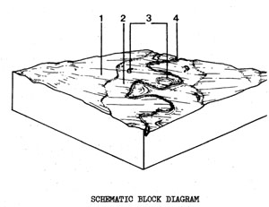 | Fairly level terraces on older alluvium associated with the Leigh and Barwon Rivers in the south of the Shire. There are a total of 9.9 km2 and this represents 1.4% of the Shire. The higher terraces, that represent Component 1, are the only ones which seem unlikely to flood. Most of Inverleigh is built on these terraces; the lower terraces are used for sports grounds, grazing, cropping and other activities tolerant of seasonal waterlogging and occasional floods. SOILS The soils of the lower terraces are fairly undifferentiated, mainly consisting of blackish brown loams to clayey soils with isolated sand areas. The main soil of Component 1, the higher terraces is described below. |
Red Duplex Soils
Factual Key: Dr 2.23/SL-L, 30-45 cm/alluvial sands and clays. 60-100 cm.
Horizon | Depth (cm) | Description |
A1 | 0-5 | Dark brown (7.5YR 3/3) when moist; loamy sand to sandy loam; apedal single-grained; consistence when dry is loose; pH 6.0; abrupt boundary. |
A2 | 5-45 | Brown (7.YR 4/4) when moist; loamy sand to sandy loam; apedal single-grained; consistence when dry is slightly hard; pH 6.5; abrupt boundary. |
B2 | 45-60 | Dark reddish-brown (5YR 2/2) when moist; with brownish black (when moist) cutans (clay skins) on the outside of peds; medium clay; medium to strong blocky structure 50 mm; consistence when moist is very firm; pH 8.0; abrupt boundary. |
BC | 60-75 | Bright brown (7.5YR 5/8) when moist; with common distinct red and grey mottles; light medium clay; moderate blocky structure 20 mm; consistence when moist is firm; often with hard accumulations of lime up to 50%, 20 mm; pH 9.0. |
C | 75+ | Alluvium - brown clay with some lime and ironstone pebbles at depth. |
| COMPONENT Proportion % | 1 45 | 2 35 | 3 5 | 4 15 |
| CLIMATE | ||||
| Rainfall(av.) mm | Annual 510-570 | |||
| Temperature(av.) °C | Annual 13 | |||
| GEOLOGY | ||||
| Age, rock | Quaternary alluvium | |||
| TOPOGRAPHY | ||||
| Landscape | Broad alluvial flats in the south of the Shire | |||
| Elevation (range) m | 30 - 80 | |||
| Local relief (av.) m | 5 | |||
| Drainage pattern | - | |||
| Drainage density km/km2 | - | |||
| Land form | Terrace 2 | Terrace 1 | Depressions and billabongs in Terrace-1 | River channel bed, banks and levees |
| Position on land form | Higher terraces | Lower terraces. | Low lying wet areas | - |
| Slope (range) %, slope shape | 0-3 ; Straight | 0-2 : Straight | 0-2 ; Concave | 0-2 ; Concave |
| NATIVE VEGETATION | ||||
| Structure | Open forest | |||
| Dominant species | E. leucoxylon E. camaldulensis | E. camaldulensis | ||
| SOIL | ||||
| Parent material | Unconsolidated gravel, sand, silt and clay | |||
| Description | Red duplex soils - some dark duplex soils | Dark uniform loams | Dark clay soils | Channel - variable; levee - uniform fine sands |
| Factual key | Dr 2.23 and Dd 2.13 | Um 1.2 | Dd 2.43. Ug. Um | Uc 1.23 |
| Surface texture | Loamy sand and sandy loam | Loam - clay loam | Clay loam to clay | Variable |
| Permeability | Moderate | High | Low | - |
| Depth (range) m | 0.5 - 1.0 | 0.2 - 0.8 | 0.8 - 1.5 | - |
| LAND USE | ||||
Residential, grazing, some cropping | Cropping, grazing, sporting facilities (flood hazard) | Grazing | Recreation | |
| SOIL DETERIORATION | ||||
| Critical land features | Limited permeability | Low situation affected by flooding from river | ||
| Processes | Overland flow | Overland flow, periodic waterlogging | Overland flow, periodic waterlogging | |
| Forms | Minor sheet erosion on exposed soil | Siltation | Streambank erosion | |
Qyad - Terraces with Variable Soils on Quaternary Sediments. Drier than Qya
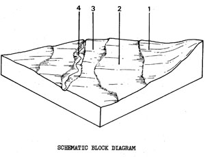 | River and stream deposits of clay, silt, sand and gravel in the southern half of the Shire. The 6.7 km2 total area of the unit represents 0.9% of the Shire. River channel, banks and terraces are the landforms comprising this unit. The special arrangement of these and the number of terraces present at any locality is very variable within the unit. The soil profile shows greatest differentiation on the higher, older terraces and least on the lower, younger ones. The higher terraces are mainly used for grazing, with some fodder crops and market gardening where the terraces are wider. Waterlogging and flooding on the lower terraces limit their usefulness for purposes other than passive recreation. SOILS The soils of Component-2 (the most common component) are variable ranging from loams to clays. As no meaningful soil description can be given at this scale, the description that follows is for duplex soils of a higher terrace. |
Mottled Yellow Duplex Soils
Factual Key: Dy 3.41/CL, 15-40 cm/alluvium, 70-150 cm
Horizon | Depth (cm) | Description |
A1 | 0-10 | Dark brown (10YR 3/4) when moist; clay loam; apedal and massive; consistence when slightly moist is friable; pH 4.8; clear boundary. |
A2 | 10-20 | Dull yellowish brown (10YR 5/3) when moist; sandy clay loam; apedal and massive; consistence when slightly moist is friable; pH 4.3; diffuse boundary. |
B | 20-100 | Bright yellowish brown (10YR 4/8) when moist; with abundant distinct red or yellow brown mottles: medium clay; strong angular blocky 40 mm breaking down to an angular blocky 2 mm; consistence when slightly moist is firm; pH 5.3. |
C | 100+ | Alluvial deposits - stratified clays, sands and gravel. |
| COMPONENT Proportion % | 1 30 | 2 50 | 3 5 | 4 15 |
| CLIMATE | ||||
| Rainfall(av.) mm | Annual 500 - 600 | |||
| Temperature(av.) °C | Annual 13 | |||
| GEOLOGY | ||||
| Age, rock | Quaternary alluvium | |||
| TOPOGRAPHY | ||||
| Landscape | Scattered occurrences of alluvium in centre and south of Shire | |||
| Elevation (range) m | 30- 260 | |||
| Local relief (av.) m | 10 | |||
| Drainage pattern | 1. | |||
| Drainage density km/km2 | 5.2 | |||
| Land form | Terraces | Terrace | Stream channel | |
| Position on land form | Higher terraces | Middle terrace | Low | Lowest |
| Slope (range) %, slope shape | 1-5; straight | 2-3 ; straight | 1-2 ; straight | Variable |
| NATIVE VEGETATION | ||||
| Structure | Woodland (?) | |||
| Dominant species | E. camaldulensis | |||
| SOIL | ||||
| Parent material | Unconsolidated alluvial Sediments | |||
| Description | Mottled yellow duplex soils | Dark uniform soils (variable) | Uniform - variable sands through to clays | Variable - from clayey to stony materials |
| Factual key | Dy 3.42 | Um 5.52 and others | Uc - Ug | - |
| Surface texture | Clay, loam | Clay loam | Variable | - |
| Permeability | Moderate - low | Moderate - low | Variable | - |
| Depth (range) m | 1 - 2 | 1 - 2 | 1 | - |
| LAND USE | ||||
Grazing | Grazing with some market gardens | Recreation | ||
| SOIL DETERIORATION | ||||
| Critical land features | Hard setting surfaces | Low situation affected by flooding from river | Exposed soil surfaces | |
| Processes | Overland flow | Overland flow, periodic waterlogging | Undercutting by stream, periodic waterlogging | |
| Forms | Minor sheet erosion | Siltation | Stream-bank erosion | |
Qau - Higher Terraces with Duplex Soils on Quaternary and Ordovician Sediments
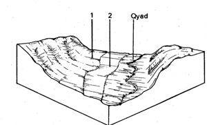 | Higher terraces adjacent to the lower alluvial terraces of Qyad, occurring east of Maude, on the Moorabool River. The 1.0 km2 total area represents only 0.1% of the Shire. 1.5 to 2.5 metres of soil and unconsolidated material overlies sedimentary rock and appears to be alluvium deposited on terraces cut into the Ordovician sediments. It is the presence of sedimentary rock close to the surface which separates the terraces of this unit from those of Qyad. The gentle slopes, of 1-3%, are used for cropping and grazing. The unit is not flood prone. SOILS Neither of the components show any signs of erosion except for minor sheet erosion during fallow periods. The soils are moderately sodic - especially the lower component. |
Red Mottled Yellow Duplex Soils
Factual Key: Dy 3.42/FSL, 40-70 cm/alluvium, 100-150 cm
Horizon | Depth (cm) | Description |
A1 | 0-50 | Dark brown (10YR 3/3) when moist; hydrophobic fine sandy loam; apedal and massive; consistence when dry is soft; pH 5.5; clear boundary. |
A2 | 50-60 | Yellowish brown (10YR 3/3) when moist; fine sandy loam; apedal and massive; consistence when dry is soft; pH 6.0; abrupt boundary. |
B | 60-100+ | Yellowish brown (10YR 5/4) when moist; with red mottles; heavy clay; strong subangular blocky 20 mm; consistence when slightly moist is extremely firm; contains some rounded pebbles; pH 8.0. |
| COMPONENT Proportion % | 1 60 | 2 40 |
| CLIMATE | ||
| Rainfall(av.) mm | Annual 580 - 600 | |
| Temperature(av.) °C | Annual 12 | |
| GEOLOGY | ||
| Age, rock | Quaternary alluvium on Ordovician sediments | |
| TOPOGRAPHY | ||
| Landscape | Cut and fill terraces east of Maude adjacent to the Moorabool River | |
| Elevation (range) m | 65-90 | |
| Local relief (av.) m | 15 | |
| Drainage pattern | Dendritic | |
| Drainage density km/km2 | 3.0 | |
| Land form | Terraces | |
| Position on land form | Upper | Lower |
| Slope (range) %, slope shape | 1-4 ; Straight | 1-2 ; Straight |
| NATIVE VEGETATION | ||
| Structure | Woodland ? | |
| Dominant species | E. camaldulensis | |
| SOIL | ||
| Parent material | Unconsolidated river deposits | |
| Description | Red mottled yellow duplex soils | Yellow mottled yellow duplex soils |
| Factual key | Dy 3.42 | Dy 3.43 |
| Surface texture | Fine sandy loam | Sandy loam |
| Permeability | Moderate | Moderate |
| Depth (range) m | 1.0 - 2.0 | 0.8 - 1.5 |
| LAND USE | ||
Cropping and grazing | ||
| SOIL DETERIORATION | ||
| Critical land features | Hard setting surfaces | |
| Processes | Overland flow | |
| Forms | Minor sheet erosion | |
Qsm - Valley floor with Uniform and Duplex Soils on Mixed Parent Materials
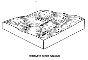
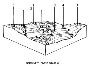 | A wide valley floor containing large sand deposits with scattered occurrences of basalt (Qbgd) and Tertiary sediments (Tgs) and with alluvium in the depressions (Qyad). All these components are too small to be mapped separately at this scale. There are three occurrences of the unit - two in the south-west and one in the south-east corner of the Shire. The total area of 8.8 km2, represents 1.2% of the study area. Although the macro-relief of the valley floor is fairly level, on a micro-scale, it has many short, sharp slopes and rises. The sandy ridges and hummocks occur randomly across this landscape. Extractive industries are slowly removing many of the larger sand deposits. Unless quickly revegetated, the loose sands are easily washed or blown away. SOILS Soil descriptions for the basalt, Tertiary and alluvial soils can be found in units Qbgd, Tgs and Qyad respectively. The soil described below occurs on the sandy ridges and hummocks (Component 1). |
Brown Sand Soils - Uniform Texture
Factual Key: Uc 1.21/LS-S, 10-25 cm/unconsolidated sand, 50-80 cm
Horizon | Depth (cm) | Description |
A | 0-20 | Dark greyish brown (10YR 4/2) when moist; loamy sand; apedal and single-grained; consistence when slightly moist is loose; pH 6.0; diffuse boundary. |
B | 20-60 | Brown (7.5YR 5/4) when moist; sand; apedal and single-grained; consistence when moist is loose; pH 6.0; diffuse boundary. |
C | 60-100+ | Light brown (7.5YR 6/4) when moist sand; apedal and single-grained; consistence when moist is loose; pH 6.5. |
| COMPONENT Proportion % | 1 60 | 2 15 | 3 10 | 4 10 | 5 5 |
| CLIMATE | |||||
| Rainfall(av.) mm | Annual 560 - 580 | ||||
| Temperature(av.) °C | Annual 13 | ||||
| GEOLOGY | |||||
| Age, rock | Holocene sand | Pleistocene basalt | Tertiary unconsolidated sediments | Holocene alluvium | Tertiary ? ferrocrete |
| TOPOGRAPHY | |||||
| Landscape | Wide creek valley with a broad and generally level but hummocky floor; south of survey area | ||||
| Elevation (range) m | 30 - 107 | ||||
| Local relief (av.) m | 7 | ||||
| Drainage pattern | Dendritic | ||||
| Drainage density km/km2 | 2.8 | ||||
| Land form | Sandy ridges, scarps and hummocks | Level areas and rock outcrops | Lower lying areas between hummocks | Drainage line | Outcrop |
| Position on land form | Upper slope | Mid slope | Lower slope | Mid slope | |
| Slope (range) %, slope shape | 2-15 ; Convex | 1-2 ; Convex | 1-3 ; Straight | 1-2 ; Straight | 3-8 ; Convex |
| NATIVE VEGETATION | |||||
| Structure | Woodland ? | ||||
| Dominant species | E. viminalis | E. camaldulensis | |||
| SOIL | |||||
| Parent material | Unconsolidated sands | In-situ weathered rock | Unconsolidated sediments | Unconsolidated sediments | Unconsolidated sediments |
| Description | Brown sand soils, uniform texture | Mottled yellow duplex soils, coarse structure | Mottled red duplex soils | Uniform soils (variable) | Mottled brown duplex soils |
| Factual key | Uc 1.21 | Dd 2.43 | Dr 3.22 | Uc - Urn | Db 2.22 |
| Surface texture | Loamy sand | Clay loam | Fine sandy loam | Silty clay loam (variable) | Fine sandy loam |
| Permeability | High | Moderate-low | High-moderate | High | Moderate |
| Depth (range) m | 0.7 - 1.5 | 0.5 - 1.0 | 0.5 - 1.5 | 1.0 - 2.0 | 0.3 - 0.80 |
| LAND USE | |||||
Sand extraction | Grazing | ||||
| SOIL DETERIORATION | |||||
| Critical land features | Nutrient holding capacity | Hard setting surface, slowly permeable sub-soils | Slope gradient | Slope position, flooding | Slope gradient |
| Processes | Leaching | Overland flow, periodic waterlogging | Overland flow | Waterlogging, stream-bank undercutting | Overland flow |
| Forms | Nutrient decline | Compaction of surfaces, low sheet erosion | Low sheet erosion | Stream-bank erosion | Moderate sheet erosion |
Qded - Depressions with Heavy Clay Soils on recent sediments drier than Qde
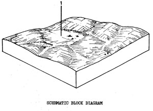 | Swamps and depressions in the southern part of the Shire. There are only a few small areas, totalling 2.7 km2 or 04% of the Shire. The tendency to waterlogging and seasonal ponding of water, limits any intensive use of these areas. They are generally used for light grazing. SOILS The soils are usually dark near the surface but may be lighter or gleyed at depth. The following describes the most common soil type. |
Black Uniform Clay Soils - Coarse Structure
Factual Key: Ug 5.1/C, 20 cm/variable (generally basalt), 100+ cm
Horizon | Depth (cm) | Description |
A | 0-20 | Brownish black (7.5YR 2/2) when moist with bright brown rootline oxidation; light medium clay; strong angular blocky 3 mm; pH 6.0; diffuse boundary. |
B | 20-100+ | Brownish black (10YR 2/2) when moist; medium clay; strong angular blocky 10 mm; consistence when wet is very plastic; pH 6.0. |
| COMPONENT Proportion % | 1 100 |
| CLIMATE | |
| Rainfall(av.) mm | Annual 500 - 600 |
| Temperature(av.) °C | Annual 13 |
| GEOLOGY | |
| Age, rock | Recent clays, silts and sands |
| TOPOGRAPHY | |
| Landscape | Swamps and depressions in the centre and south of the Shire |
| Elevation (range) m | 80 - 230 |
| Local relief (av.) m | 1 |
| Drainage pattern | - |
| Drainage density km/km2 | - |
| Land form | Swamps and depressions |
| Position on land form | |
| Slope (range) %, slope shape | 1-2 ; Straight |
| NATIVE VEGETATION | |
| Structure | Tussock and sedgeland |
| Dominant species | |
| SOIL | |
| Parent material | Unconsolidated clays, silts and sands |
| Description | Variable, but mainly clayey soils, e.g. dark uniform clay soils, coarse structure |
| Factual key | Ug 5.15 |
| Surface texture | Clay |
| Permeability | Low |
| Depth (range) m | 2 |
| LAND USE | |
Grazing, occasional cropping (cereal) | |
| SOIL DETERIORATION | |
| Critical land features | Slowly permeable toils, seasonal high watertables |
| Processes | Periodic waterlogging |
| Forms | Surface compaction |
Qao - Plains with Duplex Soils on Quaternary, or Older Sediments
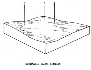 | Undulating to gently sloping plains on older alluvium in the southern part of the Shire, particularly near Inverleigh. The total area of 9.0 km2, represents 1.3% of the study area. There are some similarities between Qao and the Tertiary plains of Tgs. Both are on fairly old deposits of unconsolidated material, although the Tgs deposits are older, and both have ironstone on higher areas. The main land use is grazing, with cereal cropping in some areas. The higher parts of the town of Inverleigh are located on the unit. SOILS There are two common soil types - the mottled yellow duplex soils of the higher land (Components 1 & 2) and the red duplex soils of the lower or flatter land (Component 3) - the latter often have dark clay skins around the peds of the subsoil clay. The soils of Component 2 are described below, while those for Component 3 are similar to those described for unit Qah. |
Horizon | Depth (cm) | Description |
A1 | 0-10 | Dark brown (10YR 3/3) when moist; hydrophobic, sandy loam; apedal and massive; consistence when dry is hard; pH 6.0; abrupt boundary. |
A2 | 10-30 | Dull yellowish brown (10YR 5/3) when moist; sandy loam; apedal and massive; consistence when dry is very hard; pH 6.5; abrupt boundary. |
B | 30-100+ | Bright yellowish brown (10YR 6/6) when moist with many red or yellow mottles; medium clay; strong angular blocky 2 mm; consistence when moist is firm; pH 7.5 |
| COMPONENT Proportion % | 1 10 | 2 45 | 3 45 |
| CLIMATE | |||
| Rainfall(av.) mm | Annual 510 - 570 | ||
| Temperature(av.) °C | Annual 13 | ||
| GEOLOGY | |||
| Age, rock | Older alluvium (Quaternary - Tertiary?) | ||
| TOPOGRAPHY | |||
| Landscape | Undulating plains in the south of the Shire | ||
| Elevation (range) m | 55 - 85 | ||
| Local relief (av.) m | 15 | ||
| Drainage pattern | Dendritic | ||
| Drainage density km/km2 | 0.7 | ||
| Land form | Undulating plain | ||
| Position on land form | Crest | Mid-slope | Lower elope |
| Slope (range) %, slope shape | 0.3 ; Convex | 2-5 ; Straight | 1-2 ; Straight |
| NATIVE VEGETATION | |||
| Structure | Open forest | ||
| Dominant species | E. leucoxylon | ||
| SOIL | |||
| Parent material | Ferricrete and ferruginous sandy gravels | Unconsolidated older alluvium - clay, sand and gravel | |
| Description | Gravelly red mottled yellow duplex soils fine structure | Mottled yellow duplex soils | Red duplex soils, medium to coarse structure |
| Factual key | Dy 3.42 or Dy 3.43 | Dy 3.43 | Dr 2.25 |
| Surface texture | Fine sandy loam | Fine sandy loam | Fine sandy loam |
| Permeability | Moderate | Moderate | Moderate to low |
| Depth (range) m | 0.3 - 0.9 | 0.8 - 1.5 | 0.5 - 1.0 |
| LAND USE | |||
Grazing, gravel extraction | Grazing, residential, cereal cropping | ||
| SOIL DETERIORATION | |||
| Critical land features | Limited permeability | ||
| Processes | Overland flow | ||
| Forms | Minor sheet erosion on exposed soil | ||


