
A Study of Land Capability in the Shire of Bannockburn
"A Study of Land Capability in the Shire of Bannockburn" describes a study carried out by P J Jeffrey - Land Studies Section and R T Costello - Land Capability Section of the former Soil Conservation Authority covering the environment of the Shire of Bannockburn and the capability of the different types of land to support various land uses - particularly subdivision. The study was completed in February 1981.
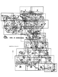
There are forty-two map units described in the study. Many of these units are complex land systems containing up to three or four different but related types of land. (i.e. land components).
The capability of the land to support three main activities has been examined.
1. Erosion risk associated with soil disturbance.
2. Constraints on construction (small buildings, secondary roads, etc.).
3. Effluent disposal by soil absorption - risk of failure and difficulties of installation.
Land Unit Descriptions & Capability Units
| Soils on Quaternary Unconsolidated Sediments | Soils on Tertiary Unconsolidated and Consolidated Sediments |
| Soils on Basaltic Terrain | Soils on Granitic Terrain |
| Soils on Older Consolidated Sediments |
 |
A Study of Land Capability in the Shire of Bannockburn (PDF - 1198 KB) A Study of Land Capability in the Shire of Bannockburn (DOC - 3060 KB) To view the information PDF requires the use of a PDF reader. This can be installed for free from the Adobe website (external link). |
© State of Victoria (Agriculture Victoria) 1996 - 2025.

This work, Victorian Resources Online, is licensed under a Creative Commons Attribution 4.0 licence. You are free to re-use the work under that licence, on the condition that you credit the State of Victoria (Agriculture Victoria) as author, indicate if changes were made and comply with the other licence terms.
The licence does not apply to ‘branding’ or some ‘images or photographs’ that may be owned by third parties. We ask you to seek prior approval to use images using the VRO feedback form. Access to higher quality images can also be provided on request.
This page was last updated on 23/03/2020.