
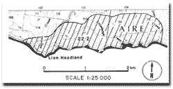
22.2 Lion Headland to Slippery Point
|
This information has been developed from the publications:
|
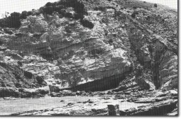
| Location: | 22-015078 to 055073. Coastal sector three kilometres west of Johanna. | 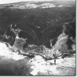 Lion Headland - high marine cliffs and hanging valley at mouth of Paynton Creek. Arrow indicates sea cave. |
| Access: | Hider Road off Great Ocean Road or coastal walk from Johanna Beach. | |
| Ownership: | Crown land (Otway National Park) and private land. | |
| Geology/Geomorphology: | The principal features of this section are broadly similar to those described at Sites 21.3 and 22.1. Otway Group sediments outcrop with southerly dip as high cliffs at Lion Headland with Paynton Creek as a hanging valley possibly aligned along a fault. Steep cliffs occur at the mount of Knowledge Creek which has incised down to sea level although the small stream immediately to the east is suspended four metres above the shore platform. As in the previous sector, this site has large landslip amphitheatres and landslip debris has accumulated as slabby boulder beaches. | 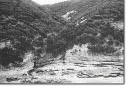 Small hanging valley at mouth of Knowledge Creek. |
| Depositional and deformational structures are clearly displayed and include bedding features, ripple marks, breccia beds and numerous small concretions. Shore platforms are narrow, irregular and deeply indented. Of particular interest are several sea caves. The most accessible of these is at the mouth of Knowledge Creek where the cavern occurs along bedding planes due to the collapse and wave removal of several siltstone beds. The cave has several conspicuous speleothems at the entrances and smaller ones on the roof inside. Other small caves are cut along vertical joint planes. The small cove 800 metres east of Knowledge Creek is of the "Lulworth Cove" type where a bay has been excavated in softer rocks behind a breached cliff of harder sandstones. | 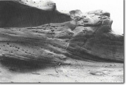 Cross-bedded arkose at Knowledge Creek. | |
Just east of Lion Headland, a preliminary survey by the National Museum of Victoria revealed a very good specimen of dinosaur footprint over 10 cms long. | ||
Significance: | International. The site is rated equally with sites 21.3 and 22.1 and reference should be made to the significance statement for those sites. Of particular importance here is the dinosaur footprint, one of only two known in Victoria and one of the best specimens yet recovered in Australia. The number of sea caves which occur in close proximity are of special interest because they display several modes of formation. The speleothems at the Knowledge Creek locality are in good condition and await more detailed mineralogical study. | |
| 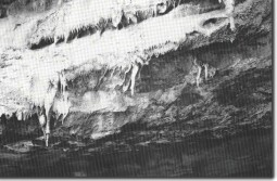 Speleothems at the entrance to Knowledge Creek cave. | |
© State of Victoria (Agriculture Victoria) 1996 - 2025.

This work, Victorian Resources Online, is licensed under a Creative Commons Attribution 4.0 licence. You are free to re-use the work under that licence, on the condition that you credit the State of Victoria (Agriculture Victoria) as author, indicate if changes were made and comply with the other licence terms.
The licence does not apply to ‘branding’ or some ‘images or photographs’ that may be owned by third parties. We ask you to seek prior approval to use images using the VRO feedback form. Access to higher quality images can also be provided on request.
This page was last updated on 23/03/2020.