
22.1 Moonlight Head to Milanesia Beach
|
This information has been developed from the publications:
|
| Location: | 21-938070 to 22-005080. Five kilometres south of Lower Gellibrand. The site extends from west of Moonlight Head to the mouth of Running Creek. | 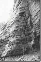 Massive arkose beds at Moonlight Head. |
| Access: | Track off Moonlight Head Road; Wattle Hill Track and private tracks from Great Ocean Road. Access to most places involves extensive walks along and down steep slopes. | |
| Ownership: | Crown land (Otway National Park) and private land. | |
Geology/Geomorphology: | This long section of coastline includes an array of coastal landforms unique in the Shire of Otway and Victoria. This introduction describes the broad nature of the geology and geomorphology and is supplemented by short site descriptions of several outstanding features. The coastal slopes differ markedly from those east of Cape Otway. The rocks outcropping are Otway Group sediments of two principal types - channel sandstones and floodplain and overbank spill deposits (Marshallsea, 1982; Duddy, pers. comm.). The channel sandstones (including the Moonlight Head Member of Baker (1950)), are in massive beds up to 30 metres thick and show a number of depositional structures including large scale cross bedding, mud chip conglomerate lenses and some beds contain abundant woody fragments. The floodplain beds consist of thinner sandstones with inter-bedded mudstones and coal layers. The beds dip generally to the south west with local variation. In places, true dip readings are difficult to determine because of major landslip displacement. Exposure is abundant in the cliffs and shore platforms although many places are extremely difficult to access. All beds are strongly jointed and there is minor folding and faulting. Coastal configuration is determined by rock structure and by the development of massive landslips. These are commonly in the form of large, irregular slump amphitheatres which may extend inland for several hundred metres. Shore platforms are irregular and often buried by landslip debris at the cliff foot. Most beaches are of boulders and gravel and include some massive slabby fragments derived from recent cliff collapse. There are sea caves, large rock stacks and deeply indented gutters across the shore platform. A number of important fossil sites have also been noted. | |
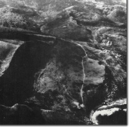
| Moonlight Head | A vertical and in places overhanding cliff rises 50 metres and provides one of the best vertical exposures of Otway Group along the entire coast. Numerous structures are clearly displayed including cross bedding, scour and fill channels and variable sizes of concretions. The cliff is intersected by widely spaced vertical joints and faults. Mudstone beds in the sequence contain a well preserved assemblage of compressed leaves and fruits that differ in special composition from other sites in the Otways of similar age. A sea cave (inaccessible) has developed on the east of the small bay at the cliff base. Seven hundred metres to the east is a massive active landslip. The slip is 600 metres wide and extends inland for 500 metres. The slumped material extends the shoreline seaward for 50 metres and provides rock fragments that have developed as a boulder and gravel beach. This is possibly the largest single landslip on the Victorian coast. | 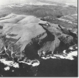 Landslip and marine cliffs at Moonlight Head. |
| Point Reginald; Cape Volney, Ryans Den | The coastline is intricate with narrow cliffed spurs projecting seaward as headlands and ending as isolated blocks or stacks. Large scale landslide block separation has formed high scarps above the active marine cliffs. | 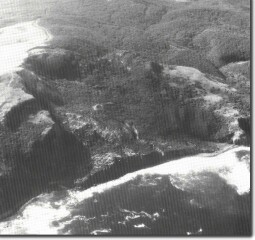 Massive landslip east of Moonlight Head. |
| Bowker Point | East and west of here, the Otway Group sediments dip south to south east on the eastern limb of the Crowes Anticline. The coastal slopes and shoreline are dominated by multiple and complex landslips that mask the bedrock and form steep and highly unstable cliffs. Coarse boulder beaches develop from the slipped and fallen landslip blocks. In the cliff and shore platform near the mouth of Milanesia and Running Creek are several small southerly-plunging folds. The sandstones here contain numerous small concretions. | 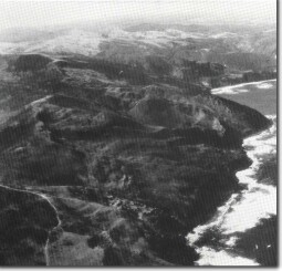 Landslip eascarpments - Cape Volney to Bowker Point. |
Significance: | International. The coast has an assemblage of landforms not represented on such a scale elsewhere in Victoria and ranks as one of the most active cliffed coastal sectors in Australia. The evolution of coastal slopes differs markedly from elsewhere in the state due to the varied structure and lithology, and exposure to a high wave energy environment. The examination of rates of slope development in this area on a Quaternary and historical time scale is of major international research potential. The extensive and varied rock exposure provide opportunity for continuing research into the origin and the structures of the Otway Group sediments. The plant fossil sites are of considerable importance and it is likely that further dinosaur fossils will be found. | |
| References: | Baker, G. (1950). "Geology and physiography of the Moonlight Head district." Proc. R. Soc. Vict. 60: pp. 17-44. Douglas, J.G. (1969). "Palynology of the Australian Cretaceous: A review Stratigraphy and Palaeontology." Essays in Honour of Dorothy Hill (Ed. S.W. Campbell), Canberra. Dudley (pers. comm). Marshallsea, S.J. (1982). "The geology of the Johanna River area." B. Sc. Hons. Report (unpub.) Univ. of Melb. | 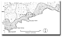 Site 22.1 |
 Coastal escarpments at Bowker Point where landslide debris has prograded the coast. | 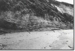 Small plunging folds - Milanesia Beach |
© State of Victoria (Agriculture Victoria) 1996 - .

This work, Victorian Resources Online, is licensed under a Creative Commons Attribution 4.0 licence. You are free to re-use the work under that licence, on the condition that you credit the State of Victoria (Agriculture Victoria) as author, indicate if changes were made and comply with the other licence terms.
The licence does not apply to ‘branding’ or some ‘images or photographs’ that may be owned by third parties. We ask you to seek prior approval to use images using the VRO feedback form. Access to higher quality images can also be provided on request.
This page was last updated on .