
9.6 Tertiary Gravels - Gellibrand
This information has been developed from the publications:
|
| Location: | 9-213310. Two kilometres south of Gellibrand and 100 m north east of Site 9.5. | |
Access: | Gellibrand-Beech Forest Road. | |
Ownership: | Private land. | |
Geology: | Gravel beds contained in the Dilwyn Formation include large pebbles of material that has not been derived from the Otway Group. Kenny (1938) suggested that some may have originated in the Grampians area but no further study of origin or mode of transport has been made since his work. | |
Significance: | Regional. The coarseness of the gravel beds is unusual in the Tertiary sediments of the Gellibrand area. | |
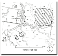
Map of Gellibrand and Sites 9.3, 9.4, 9.5, 9.6
© State of Victoria (Agriculture Victoria) 1996 - .

This work, Victorian Resources Online, is licensed under a Creative Commons Attribution 4.0 licence. You are free to re-use the work under that licence, on the condition that you credit the State of Victoria (Agriculture Victoria) as author, indicate if changes were made and comply with the other licence terms.
The licence does not apply to ‘branding’ or some ‘images or photographs’ that may be owned by third parties. We ask you to seek prior approval to use images using the VRO feedback form. Access to higher quality images can also be provided on request.
This page was last updated on .