
8.5 Carlisle River - High Level Lake
|
This information has been developed from the publications:
|
| Location: | 8-307096. One and a half kilometres north of the Carlisle River bridge. | 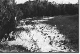 Lake shoreline and dessicated peat. |
Access: | Track off Black Bridge Road. | |
Ownership: | Crown land. | |
Geomorphology: | This is a small lake similar in form and origin to those at Site 7.8A and 7.8B. There is more peat on the lake floor at this site and small sand beaches occur at the margin. | |
Significance: | Regional. There are a few of this lake type left in the Otway Shire due to extensive land clearing of the terrain in which they develop. This example on Crown Land should be left with an undisturbed catchment as indicated by the area of the site. | |
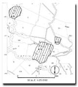 Site 8.3, 8.4, 8.5 |
© State of Victoria (Agriculture Victoria) 1996 - 2025.

This work, Victorian Resources Online, is licensed under a Creative Commons Attribution 4.0 licence. You are free to re-use the work under that licence, on the condition that you credit the State of Victoria (Agriculture Victoria) as author, indicate if changes were made and comply with the other licence terms.
The licence does not apply to ‘branding’ or some ‘images or photographs’ that may be owned by third parties. We ask you to seek prior approval to use images using the VRO feedback form. Access to higher quality images can also be provided on request.
This page was last updated on 23/03/2020.