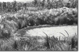
7.8 A/B Perched Lakes - Sandy Creek
|
This information has been developed from the publications:
|
| Location: | 7.8A - 7 - 065267. 7.8B - 7 - 064255. Four kilometres south west of Carlisle River. |  Small lake at Sandy Creek. |
Access: | Egan Track. | |
Ownership: | Crown land. | |
Geomorphology: | Site 7.8A comprises three small lakes and site 7.8B has one lake. The lakes are oval shaped and situated in small depressions measuring approximately 40 to 50 metres in diameter. The lakes occur in an area of woodland and heath which is the common vegetation of the leached sandy Tertiary sediments on the north western flanks of the Otway Ranges. In part, these deep sands have been re-arranged by wind action and the topography is thus a composite of depressions and ridges due to eolian action and drainage dissection and deposition. The lake floors are impermeable horizons in the underlying sediments (either clay beds or hardpan weathering horizons) or are formed on a local water table. The beds contain a variable thickness of peat and if this contains pollen and sphagnum, it is of considerable interest for vegetation and palaeoclimatic studies. | |
Significance: | State. These lakes and the distinctive sandy terrain may be compared with features of similar origin in Gippsland and also in Western Victoria e.g. the Portland District. Examination of the lake floor sediments is of considerable importance in studies of Quaternary climates in south-eastern Australia. | |


