
11.2 Barwon River East Branch Landslip
This information has been developed from the publications:
|
| Location: | 11-405278. Seven kilometres south east of Forrest. | |
Access: | Kaanglang Road. | |
Ownership: | Crown land (Reserved Forest). | |
Geomorphology: | This forested area shows evidence of former large scale landslide activity on a scale comparable to that which blocks the Barwon River at Site 11.1. | |
Significance: | Regional. The site illustrates the nature of landslip activity in forested areas. The nature of the ground surface makes an interesting comparison with more recent movements at Site 11.1. | |
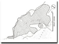
Map of Lake Elizabeth.
© State of Victoria (Agriculture Victoria) 1996 - .

This work, Victorian Resources Online, is licensed under a Creative Commons Attribution 4.0 licence. You are free to re-use the work under that licence, on the condition that you credit the State of Victoria (Agriculture Victoria) as author, indicate if changes were made and comply with the other licence terms.
The licence does not apply to ‘branding’ or some ‘images or photographs’ that may be owned by third parties. We ask you to seek prior approval to use images using the VRO feedback form. Access to higher quality images can also be provided on request.
This page was last updated on .