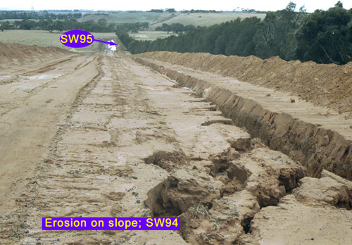
SW95
Location: Batesford
Australian Soil Classification: Vertic (& Calcic), Mottled-Hypernatric, Black SODOSOL
General Landscape Description: Alluvial plain.
Site Description: Flat.
Geology: Alluvium derived from Basalt and Moorabool Viaduct.

SW95 Landscape.
Soil Profile Morphology:
Surface Soil
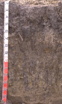
| Ap | 0-10 cm | Very dark greyish brown (10YR3/2 moist); fine sandy clay loam; granular polyhedral structure; firm consistence dry; pH 6.4: |  SW95 Profile - Note: Ap horizon stripped from soil profile. |
| Subsoil | |||
| B21tss | 10-55/60 cm | Black (2.5Y2/1); heavy clay; very coarse prismatic, parting to medium prismatic, parting to coarse angular blocky structure; rigid consistence dry; slickensides (30-100 mm) at base; pH 8.3; gradual change to: | |
| B22gt | 55/60-100 cm | 60-75 cm depth: mottled very pale brown (10YR8/3-7/3 moist) with yellowish brown (10YR5/4-5/6 moist) in ped interiors; fine sandy light clay; prominent black vertical root channels and infill between peds; some small manganiferous accumulations; 75-100 cm depth: dark yellowish brown (10YR4/4-4/6 moist); light medium clay; medium prismatic, parting to fine angular blocky structure; sand and small hard calcium carbonate and silicone (CaCO3/Si) nodules (<5%); pH 8.9; diffuse and wavy change to: | |
| B23gk | 100-130 cm | Greyish brown (2.5Y5/2 moist); light clay (silty); medium to coarse irregular prisms, parting to medium angular blocky structure; moderately calcareous; frequent infill into root channels (~50 mm) intervals; pH 8.9: | |
| B24 | 130+ cm | Mottled light yellowish brown (10YR6/4); sandy clay; weak blocky structure. |
Key Profile Features:
- Strong texture contrast between surface (A) horizons and subsoil (B21) horizon.
Soil Profile Characteristics:
pH | Salinity Rating | |||
Surface (A1 horizon) | Slightly Acid | Low | None | None |
Subsoil (B21 horizon) | Moderately Alkaline | Low-Moderate | Strongly Sodic | Strong1 |
Deeper Subsoil (at 45-60 cm) | Strongly Alkaline | Very High | Strongly Sodic | Slight2 |
| 1 Complete dispersion after remoulding. 2 Strong dispersion after remoulding could be due to the high levels of salt. | ||||

| The surface is slightly acid. The subsoil is moderately alkaline becoming strongly alkaline at depth. | Salinity rating is low in the surface. The subsoil is low to moderate becoming very high in the deeper subsoil. | The soil is non sodic in the surface and strongly sodic in the subsoil. | The clay content increases markedly at the A/B boundary. |
Horizon | Sample Depth (cm) | pH (water) | pH (CaCl2) | EC 1:5 | NaCl % | Exchangeable Cations | |||
Ca | Mg | K | Na | ||||||
meq/100g | |||||||||
Ap | 0-10 | 6.4 | 5.8 | 0.25 | 10 | 4.9 | 0.4 | 0.5 | |
B21tss | 10-55 | 8.3 | 7.4 | 0.44 | 0.07 | 7 | 11 | 0.3 | 4.5 |
B22gt | 55-90 | 8.9 | 8.1 | 0.72 | 0.13 | 4.3 | 8.1 | 0.2 | 4.9 |
B23 | 90-130 | 8.9 | 8.4 | 1.5 | 0.33 | 5.1 | 11 | 0.3 | 7.3 |
Horizon | Sample Depth (cm) | Organic Carbon % | Exchangeable Acidity meq/100g | Nitrogen % | Field Capacity pF2.5 | Wilting Point pF4.2 | Coarse Sand (0.2- 2.0 mm) | Fine Sand (0.02- 0.2 mm) | Silt (0.002- 0.02 mm) | Clay (<0.002 mm) |
Ap | 0-10 | 2.9 | 8.5 | 0.27 | 33.0 | 12.9 | 3 | 31 | 31 | 29 |
B21tss | 10-55 | 36.1 | 18.3 | 2 | 26 | 25 | 44 | |||
B22gt | 55-90 | 30.5 | 15.0 | 2 | 37 | 25 | 36 | |||
B23 | 90-130 | 40.9 | 23.1 | 1 | 8 | 39 | 49 |
Management Considerations:
Subsoil (B) Horizons
- The subsoil has high levels of soluble salts, which is likely to restrict the growth of salt-sensitive species.
Profile Described By: Richard McEwan (February 1999).


