
ESAS10b
Location: Inverleigh
Australian Soil Classification: Vertic (& Ferric), Mottled-Mesonatric Grey SODOSOL
General Landscape Description: Gently Undulating Plain.
Site Description: Flat.
Land Use: Cropping.
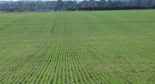
ESAS10b Landscape
Soil Profile Morphology:
Surface Soil
| A1 | 0-14 cm | Dark brown (7.5YR3/2); sandy clay loam; moderate coarse blocky, parting to moderate very fine granular structure; pH 5.6: | 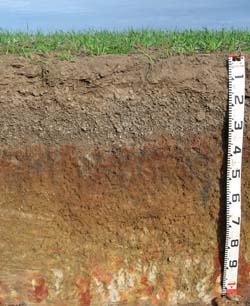 ESAS10b Profile | |
| A2 | 14-30 cm | Contains very many (80%) medium and coarse (4-15 mm in size) ferruginous nodules; pH 5.7; discontinuous layer that occurs in <20% of the exposed pit face area: | ||
| Subsoil | ||||
| B21 | 30-45 cm | Brown (7.5YR4/2) with many (50%) dark red (2.5YR3/8) mottles; medium clay; strong coarse sub-angular blocky parting to medium sub-angular blocky structure; pH 7.2: | ||
| B22 | 45-80 cm | Pale yellow (2.5Y7/4) with yellowish red (5YR5/8) mottles; medium heavy clay; moderate medium lenticular parting to fine lenticular structure; pH 8.5: | ||
| B/C | 80-110 cm | Brown (7.5YR5/4) with light yellowish brown (10YR6/4) mottles; medium heavy clay; dark stains evident; pH 8.8. | ||
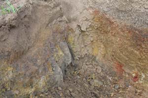 ESAS10b and ESAS10c Soil profile variability. ESAS10c is on the left and ESAS10b is on the right. | ||||
Soil Profile Characteristics:
pH | Salinity Rating | |||
Surface (A1 horizon) | Moderately Acid | Low-Medium | Non-Sodic | None |
Subsoil (B21 horizon) | Slightly Alkaline | Low | Strongly Sodic | Strong1 |
Deeper Subsoil (at 80-110 cm) | Strongly Alkaline | Low-Medium | Strongly Sodic | Strong1 |
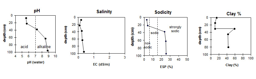
| The surface is moderately acid. The subsoil is slightly alkaline becoming strongly alkaline with depth. |
|
|
|
Horizon | Horizon Depth (cm) | pH (water) | pH CaCl2 | EC (dS/m) | NaCl % | Exchangeable Cations | |||
Ca | Mg | K | Na | ||||||
meq/100g | |||||||||
A1 | 0-14 | 5.6 | 5 | 0.17 | 3.2 | 1.2 | 0.75 | 0.31 | |
A2 | 14-30 | 5.7 | 4.9 | 0.07 | 1.4 | 0.76 | 0.19 | 0.25 | |
B21 | 30-45 | 7.2 | 6.2 | 0.21 | 4 | 9.1 | 0.77 | 4.3 | |
B22 | 45-80 | 8.5 | 7.5 | 0.26 | 0.014 | 4 | 11 | 0.81 | 5.3 |
B/C | 80-110 | 8.8 | 7.9 | 0.35 | 0.02 | 3.7 | 11 | 0.69 | 5.3 |
Horizon | Horizon Depth (cm) | Oxidisable Organic Carbon % | Total Nitrogen % | Exchangeable Acidity meq/100g | Exchangeable Aluminium mg/kg | Field Capacity pF2.5 | Wilting Point pF4.2 | Coarse Sand (0.2-2.0 mm) | Fine Sand (0.02-0.2 mm) | Silt (0.002-0.02 mm) | Clay (<0.002 mm) |
A1 | 0-14 | 1.3 | 0.11 | 4.9 | <10 | 14.8 | 5 | 34 | 39 | 9 | 15 |
A2 | 14-30 | 0.66 | <0.05 | 4.0 | <10 | 14.1 | 4.6 | 42 | 33 | 9 | 11 |
B21 | 30-45 | 40.5 | 23.3 | 18 | 13 | 6 | 59 | ||||
B22 | 45-80 | 39.1 | 21.5 | 25 | 19 | 8 | 43 | ||||
B/C | 80-110 | 31 | 14 | 8 | 44 |
Profile Described By: Mark Imhof (July 2008).
© State of Victoria (Agriculture Victoria) 1996 - 2025.

This work, Victorian Resources Online, is licensed under a Creative Commons Attribution 4.0 licence. You are free to re-use the work under that licence, on the condition that you credit the State of Victoria (Agriculture Victoria) as author, indicate if changes were made and comply with the other licence terms.
The licence does not apply to ‘branding’ or some ‘images or photographs’ that may be owned by third parties. We ask you to seek prior approval to use images using the VRO feedback form. Access to higher quality images can also be provided on request.
This page was last updated on 23/03/2020.