
Groundwater Flow Systems
Corangamite Land & Water | Salinity Management | Groundwater Flow Sytems Report
The National Land and Water Resources Audit (NLWRA) identified the Corangamite Catchment Management Authority (CCMA) region as a high-risk salinity area. As a result, the CCMA (along with the neighbouring Glenelg-Hopkins CMA) has been designated one of the priority regions in the National Action Plan for salinity and water quality (NAP). The goal of the NAP is to motivate and enable regional communities to use coordinated and targeted action to:
- Prevent, stabilise and reverse trends in dryland salinity affecting the sustainability of production, the conservation of biological diversity and the viability of our infrastructure.
- Improve water quality and secure reliable allocations for human uses, industry and the environment.
“…characterise similar landscapes in which similar groundwater processes contribute to similar salinity issues, and where similar salinity management options apply” (Coram, et al., 2001).
In Australia, twelve GFS have been identified on the basis of nationally distinctive geological and geomorphological character. In the Audit, GFS are characterised by their hydrological responses and flow paths into local, intermediate and regional systems. This terminology should not be confused with that used in classic groundwater textbooks for the nested flow systems in groundwater basins, rather, in the terminology used by the Audit local, intermediate and regional GFS are described by their response rate to hydrological change caused by alteration to the natural environment. The underlying assumption is that salinity is caused by increased recharge leading to rising groundwater tables, which have resulted from changes in land management over the past 200 years.
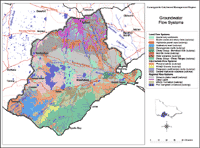
Seventeen groundwater flow systems have been delineated in the Corangamite CMA region based on the model put forward by the National Land and Water Resources Audit. Of these, nine are predominately local groundwater flow systems, four are predominately intermediate, and four are predominately regional flow systems. Consensus on the flow systems was an outcome of a three-day workshop held in Colac in November 2001, and subsequent discussions with regional experts. Approximately 55 invited experts and/or stakeholders in the groundwater and salinity issues in the CCMA region attended the workshop. |
While groundwater flow systems provide a useful tool in the understanding of salinity processes, confidence in management options for the protection of different classes of assets (agricultural land, water quality, biodiversity, infrastructure and cultural heritage) requires confidence in the conceptual model of how the groundwater and salinity processes operate. The options for salinity management in south west Victoria are constrained by the lack of scientifically validated models relating the assumed cause (land-use change) to the observed effect (salinity). There is growing evidence that land and water salinity was a more prevalent feature (than is assumed) of the landscape before widespread land-use change. In some areas, such as Lake Corangamite and associated wetlands, these primary saline areas are biodiversity assets of international importance.
One challenge in adopting the GFS approach to salinity management in the CCMA region is the recognition that the Audit’s conceptual model does not hold for all areas of south west Victoria. In some areas (e.g. Western Victorian volcanic plains, Heytesbury) the depth of the groundwater tables below the surface may be relatively unchanged over the past 200 years and other factors - such as changes to soil waterlogging and regolith hydrology - are implicated in the spread of salinity (Dahlhaus & MacEwan, 1997). In these areas, the systems are discharge-driven and recharge control is not considered as relevant to the management of salinity as the control of soil waterlogging and shallow, temporal water flows in the near-surface. In these GFS, the treatment of discharge areas can often result in a more productive outcome for agriculture or biodiversity in a shorter time frame than recharge control.
© State of Victoria (Agriculture Victoria) 1996 - 2025.

This work, Victorian Resources Online, is licensed under a Creative Commons Attribution 4.0 licence. You are free to re-use the work under that licence, on the condition that you credit the State of Victoria (Agriculture Victoria) as author, indicate if changes were made and comply with the other licence terms.
The licence does not apply to ‘branding’ or some ‘images or photographs’ that may be owned by third parties. We ask you to seek prior approval to use images using the VRO feedback form. Access to higher quality images can also be provided on request.
This page was last updated on 23/03/2020.