WLRA138
|
| WLRA138 |  Acidic, Eutrophic, Red KANDOSOL | |
|
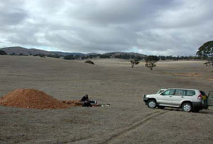
Location | Shays Flat-Malakoff Road, Landsborough, western Victoria | |||
|
Landform | Rolling rises | |||
|
Geology | White Hills Gravel: residual fluvial gravel and sand deposits | |||
|
Element | Hillslope | |||
|
Slope | 12% | |||
|
Aspect | North-north-west | |||
Horizon | Depth (cm) | Description | ||
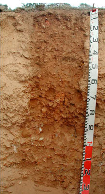
A0 | 0–2 | Very dark greyish brown (10YR3/2); silty loam; massive (structureless); common subangular fine to medium quartz gravels; many very fine and fine roots; water repellent; field pH 6.0; abrupt and smooth boundary to: | ||
A1 | 2–50 | Strong brown (7.5YR5/6); sandy loam; massive (structureless); very weak dry consistence; abundant medium to coarse quartz gravels; common fine and very fine roots; pH 5.1; gradual and smooth boundary to: | ||
B2 | 50–90 | Yellowish red (5YR5/8); sandy clay loam; very weak dry consistence; abundant fine quartz gravels to quartz stones; few fine and very fine roots; pH 5.2; gradual and smooth boundary to: | ||
C | 90–135+ | Massive (structureless); strongly cemented quartz gravels and stones. | ||
| Management Considerations | ||||
| ||||
Horizon | Depth (cm) | pH (water) | pH (CaCl2) | EC dS/m | Exch. Al mg/kg | Exchangeable Cations cmol-/kg | Field Capacity (pF2.5) | Wilting Point (pF4.2) | Coarse Sand % | Fine Sand % | Silt % | Clay % | |||
Ca | Mg | K | Na | ||||||||||||
A1 | 2–50 | 5.1 | 4.7 | 0.05 | 17 | 1 | 0.23 | 0.1 | <0.05 | 11 | 2.4 | 41.8 | 41.1 | 8.3 | 3.8 |
B2 | 50–90 | 5.2 | 4.5 | <0.05 | 35 | 1.2 | 0.81 | 0.14 | <0.05 | 10.9 | 5 | 46.8 | 28.8 | 8.5 | 13.5 |


