LSWW13
|
| LSWW13 |  | |
|
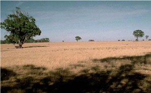
Location | Winter Lake, western Victoria | |||
|
Landform | Plain | |||
|
Geology | Quaternary swamp and lake deposits: paludal silt and clay | |||
|
Element | Plain
| |||
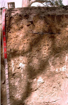
Horizon | Depth (cm) | Description | ||
AO | 0–3 | Organic layer. | ||
A1 | 3–10 | Brown (7.5YR4/2); loamy sand; weakly structured; pH 6.6: | ||
A2 | 10–20 | Pink (7.5YR7/4); sand; massive (structureless); pH 6.3: | ||
B21 | 20–40 | Very pale brown with many distinct brownish yellow mottles (10YR7/3); medium heavy clay; very coarse columnar, parting to strong medium polyhedral, parting to moderate fine polyhedral structure; clay skin cutans; dispersive when worked; pH 5.8: | ||
B22 | 40–70 | Brownish yellow (10YR6/8); sandy clay; completely dispersive; pH 7.2: | ||
B23 | 70–90 | Pale yellow (2.5Y7/4) with a few faint brownish yellow mottles; medium heavy clay, sandy; moderate coarse prismatic, parting to strong coarse blocky structure; a few manganese flecks; completely dispersive; pH 8.5: | ||
B24k | 90–150 | Light grey (2.5Y7/2); medium heavy clay, sandy; moderate coarse prismatic, parting to strong coarse blocky structure; common soft calcareous segregations with a few hard calcareous nodules; carbonate occurs in patches; pH 9.6: | ||
B25 | 150–200+ | Light grey (2.5Y7/2); medium clay, sandy; moderate coarse parting to strong medium polyhedral structure; pH 9.0. | ||
| Management Considerations | ||||
| ||||
Horizon | Depth (cm) | pH (water) | pH (CaCl2) | EC dS/m | NaCl % | Exchangeable Cations cmol-/kg | Wilting Point (pF4.2) | Coarse Sand % | Fine Sand % | Silt % | Clay % | |||
Ca | Mg | K | Na | |||||||||||
AO | 0–3 | 12.6 | ||||||||||||
A1 | 3–10 | 6.6 | 6.3 | 0.18 | 4.2 | 2 | 0.2 | 0.3 | 43 | 29.5 | 5.5 | 10.5 | ||
A2 | 10–20 | 6.3 | 5.7 | 0.05 | 18.0 | |||||||||
B21 | 20–40 | 5.8 | 4.8 | 0.22 | 2.6 | 8.1 | 0.6 | 2.5 | 9.6 | 27.8 | 16.8 | 5.5 | 44 | |
B22 | 40–70 | 7.2 | 6.2 | 0.26 | 1.5 | 5.1 | 0.2 | 2.8 | 15.3 | 39.5 | 30.7 | 5.5 | 22 | |
B23 | 70–90 | 8.5 | 7.7 | 0.55 | 0.1 | 3.2 | 10 | 0.4 | 6.6 | |||||
B24k | 90–150 | 9.6 | 8.9 | 0.74 | 0.12 | |||||||||
B25 | 150–200+ | 9 | 8.2 | 0.53 | 0.11 | |||||||||


