5.5 Ridges with sand, and flats (Goroke, Nhill)
- 5.5.1 Prominent ridge tops with remnant aeolian sands and oriented swales with lakes and lunettes (north of Little Desert)
- 5.5.2 Low ridge tops with remnant aeolian sands and oriented swales with lakes and lunettes (south of Little Desert)
- 5.5.3 Prominent ridges with eroded ferruginized northern spurs (south of the Lower Norton Wimmera Bridge)
5. North Western Dunefields and Plains (DP)
5.5.1 Prominent ridge tops with remnant aeolian sands and oriented swales with lakes and lunettes (north of Little Desert)
5.5.2 Low ridge tops with remnant aeolian sands and oriented swales with lakes and lunettes (south of Little Desert)
5.5.3 Prominent ridges with eroded ferruginized northern spurs (south of the Lower Norton Wimmera Bridge)
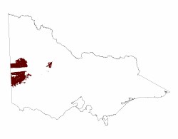
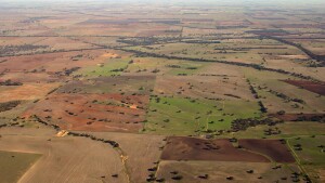
| This geomorphological unit is located in western Victoria, bordering South Australia with the unit extending into that State. The unit is spatially subdivided with the Little Desert separating the northern (5.5.1: Nhill) area from the southern (5.5.2: Goroke) area. This unit is also clearly bound by Siliceous Dunefields to the north (5.2), a Valley/depression system (5.6) to the east and a less clear boundary to the Tablelands (2.3) to the south, close to the Glenelg River. Landform The predominant landforms are a series of parallel ridges orientated to the NNW/SSE with intervening depression or flats. The ridges may vary in elevation, relative relief and morphology such that some are a complex of slope segments with higher elevation depressions while others have a simple convex form from one flat to the next. The major ridges can have a width of over 5 km with at least the same width for the adjoining flat, the smaller ridges have less width, closer to 2 km. Slope also varies with slopes of the order of 5% or less on most ridges but 8% on the larger ridges, particularly in the northern section, the southern section having more subdued relief and affected by more recent geological events as well as climate. |  |
The drainage pattern is strongly influenced by the pattern of ridges and flats with some swamps and lakes occupying the flats, particularly the southern area, where the landscape is more subdued (but slightly higher elevation) and the climate moister.
Geology, regolith and soils
The dominant geology is that of Neogene, Tertiary and Quaternary material laid down as part of the Murravian basin. The parallel ridges, consisting of Parilla Sand (Tpp) are former strandlines of the retreating Tertiary sea with the flats developing from the intervening lagoonal deposits with the western uplands thought to remain above sea level. The age of the retreating shorelines is thought to be between 2 and 6 million years ago, the majority in this geomorphological unit being about 3-4 million years old.
Subsequently windblown deposits of fine calcareous and saline material known as the Woorinen Formation (Qw) blanketed the area in the early Quaternary period (also known as parna). The most recent deposition is that of the coarser unconsolidated pale sand known as Lowan Sand (Ql) which is the major constituent of the Little Desert and also caps many ridges in the southern area.
These phases of deposition are thought to be coincident with a climatic change, the Woorinen Formation requiring a dry climate while a wetter period would be required for the lagoonal and lacustrine deposits (Qrs).
Tectonic movement is thought to be a reason why the course of the Glenelg river does not follow the exact edge of the Tableland to the south and influenced the apparent deflected strandlines that seem visible by remote sensing on the adjoining Tablelands (Joyce, 1999).
Soils types include red sodic texture contrast soils (Sodosols) in the northern area developed on the rises with mottled Sodosols in the southern area and black cracking clays (Vertosols) in the depressions. Pale sandy soils (Rudosols and Podosols) occur on the Lowan Sand in the south and some reworked areas of exposed Parilla Sand.
Vegetation and Land Use
Yellow Gum occupies the ridges and Black Box is typical of the flats. The cracking clay soils are cropped as well as the red sodic soils and the sandy soils are often forested (plantations).
| Reading / references Blackburn, G, Bond , R D and Clarke, A R P (1967) Soil development in relation to stranded beach ridges of County Lowan, Victoria. Soil Publication 24, CSIRO, Australia. Kotsonis, A (1996) Late Cainozoic landform mapping of the western Murray Basin, southeastern Australia, using night-time thermal data. Geological Society of Australia, 13th Australian Geological Convention, Canberra, 19-23 February 1996, Abtracts 41, 238. Imhof, Thompson and Rees (1995) Major Agricultural Soils in the Shire of Lowan. Blackburn, G and Gibbons, F R (1956) A Reconnaissance Survey of the Soils of the Shire of Kowree, Victoria. Soil and Land Use series No.17, CSIRO, Australia Maher, J Soil- landforms Natimuk 1:100 000 Maher, J Soil- landforms Goroke 1:100 000 Baxter N, M Shire of West Wimmera |  |


