Victorian Grain Cropping Soils - Sodosols
Back to: Soils of Victorian Grain Cropping Regions
Sodosols have strong texture contrast between surface (A) horizons and dense and coarsely structured clayey subsoil (B) horizons that are sodic (i.e. exchangeable sodium percentage is 6 or greater) and not strongly acid (i.e. pH 5.5 is or greater), in at least the upper subsoil.
Using the Australian Soil Classification, Sodosols can be separated on the basis of the colour of the upper 20 cm of the subsoil into Red, Brown, Yellow, Grey and Black Suborders. Further separations within these Suborders are made largely on the basis of key chemical characteristics in the subsoil (e.g., degree of sodicity, presence of calcium carbonate).
Distribution
Wimmera
| Hardsetting Red Sodosols usually occur on the gently undulating plains and rises to the north and south of the Little Desert (Nhill and Kaniva region) and in the eastern parts of the region (Charlton region). Minor occurrences can be found north of Horsham, associated with Vertosols, where they occur on higher landscape positions. | 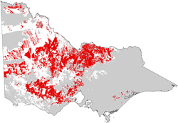 |
| The surface soil is usually a grey-brown to reddish brown sandy loam to clay loam and is slightly acid. A subsurface (A2) horizon may or may not be present. When present, it is often sporadically or conspicuously bleached. The upper clayey subsoil (B) horizon is red to reddish brown and sodic and typically dense and coarsely structured (often prismatic or columnar). The deeper subsoil can become more yellow, and may contain various amounts of soluble salts and calcium carbonate (lime) segregations. The deeper subsoils are usually alkaline to strongly alkaline. Soil profile LS15 is an example of a Red Sodosol near Netherby. | 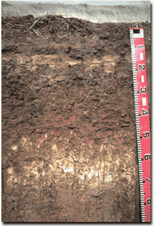 Red Sodosol in the Wimmera |
| Yellow and Brown Sodosols (often with sandy surface horizons) can occur throughout the Wimmera region where they are usually found on sand sheets, dunes and hill slopes. They are commonly found to the west of the Wimmera River. These soils are characterised by a dark surface (A1) horizon that ranges from sand to sandy loam in texture. The surface soil may or may not be hardsetting. A paler subsurface (A2) horizon is usually strongly bleached and commonly sand to loamy sand in texture. Together these horizons can range from 10 to 50 cm in thickness. A clear to abrupt boundary occurs to the clayey subsoil. Subsoils are often light brownish grey to yellowish brown with yellow and red mottles and usually dense and coarsely structured, typically prismatic or columnar. Sandy surface soils often have low levels of nutrients and lower water storage capacity, but are relatively easy to work. In some instances, the dry sand surfaces are water repellent making it difficult for water to infiltrate. The bleached subsurface (A2) horizons can be quite thick (up to 50 cm) and have a very low inherent fertility. After heavy rains water builds up on the slowly permeable subsoils and the subsurface (A2) horizon can become waterlogged. Soil profile LS17 is an example of a Yellow Sodosol south of the Big Desert. | 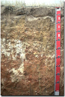 Yellow Sodosol, south of the Big Desert |
Mallee
Red Sodosols are common on older alluvial terraces in the northern Mallee region. In the southern Mallee, Red Sodosols more typically occur on higher parts of the landscape, particularly on north-south trending low ridges and associated gently undulating rises.
Northern Victoria
| Red Sodosols (previously referred to as ‘red-brown earths’) are most commonly used for cropping and occur extensively on the older alluvial plains that occupy much of the northern Riverine Plain region of Victoria. They are characterised by upper subsoils that are red in colour and sodic, and often have visible calcium carbonate (‘lime) in the deeper subsoil. In some areas (where prior streams were active) there is a textural sequence, from soils with a higher proportion of sand on prior stream levees to more clay rich soils on the floodplains. The lighter surface soils generally have higher productivity, both under dryland and irrigated farming. The heavier soils are more affected by hard-setting surfaces and lower hydraulic conductivity. Grey Vertosols often occupy lower sites in the landscape. |  Red Sodosol in northern Victoria |
| Red Sodosols often occur on gentle on Palaeozoic sediments, usually with various amounts of gravel in the upper horizons. Profiles tend to be shallow, typically less than one metre thick. Shallow stony soils are found on the steeper crests and Yellow Sodosols are more common on sites lower in the landscape. Cropping is less common as productivity is limited by factors such as low rainfall, poor soil structure, stony soil profiles and erosion (sheet and gully). Soil pit site LP43 is an example of a Red Sodosol on older marine sediments near St Arnaud. Volcanic plains with Red Sodosols are limited to the area west of the Cairn Curran Reservoir, where they are associated with Dermosols on the more dissected sites and Vertosols in drainage lines. | 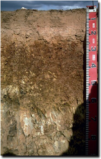 Example of a Red Sodosol near St Arnaud |
Yellow to yellow-brown Sodosols occur on hillslopes, on volcanic plains and on older alluvial plains. They are used mostly for grazing though as poor soil structure and restricted permeability are impediments to cropping.
Gippsland
| Yellow and Brown Sodosols are most common in the eastern (lower rainfall zone) part of the region, generally to the east of Traralgon. They occur on Neogene (Tertiary) plains and rises as well as on the extensive alluvial plains and river terraces deposited during the Pleistocene Period - north and south of the LaTrobe River. | 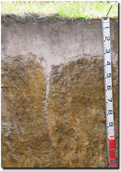 |
| South-west Victoria Black, Brown and Grey Sodosols are common on basalt plains and rises throughout much of the eastern part of the region. They also occur on sedimentary plains and rises south of the Princes Highway, generally in lower rainfall areas. The subsoils of Sodosols in the region often display strong shrinking and swelling characteristics (i.e. vertic) and the subsurface horizons can be ferric, i.e. contain significant amounts of ferruginous nodules (often referred to as ‘buckshot’). Links to some example soil profiles of Sodosols in the south-west Victoria. | 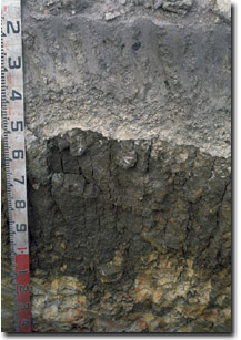 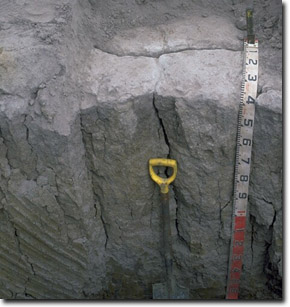 Examples of dense and coarsely structured subsoils in South West Victoria. Coarse columnar structure is evident in the subsoil of the image to the right and prismatic structure in the subsoil to the left. Both profiles display distinctive bleached subsurface horizon overlying the subsoil, often containing significant ‘buckshot’. |
Management Considerations
Management strategies for all soils should include: increasing organic matter levels in the surface soil, minimising the degradation of soil aggregates and porosity, promoting the development of stable biopores, improving the calcium status of the cation exchange complex (particularly when sodium is a significant part), and breaking up any hardpans. Less frequent tillage, using less aggressive implements and working the soil at its optimum moisture content, can all assist in maintaining soil aggregation and porosity, as well as reducing the breakdown of organic matter. Maintaining adequate levels of groundcover (e.g. stubble) is also important.
Surface (A) horizons
Sodic soils often exhibit poor soil surface structure that can result in poor plant emergence, waterlogging and ponding, and are often difficult to work when too wet or dry. Surface soil aggregates are often unstable and slake when wet. When dry the surface soil sets hard and become difficult to work. Some surface soils also disperse and seal when wet and become hardsetting and crusty when dry. Surface sealing reduces crop emergence and restricts entry of water into the soil, which can result in reduced crop yields. Raindrop action could also have a deleterious effect on bare surface soil. Reduced cultivation and/or stubble retention assists formation of aggregates by maintaining higher organic matter levels and protecting the soil from rain drop impact. Gypsum will also have an ameliorative effect on soil sodicity and resultant dispersion.
Often surface and/or subsurface horizons can disperse strongly after remoulding. This indicates that they may disperse if excessively cultivated or overstocked when wet (particularly when the soil is wetter than the ‘plastic limit’) which can degrade soil structure and increase compaction. Ideally, tillage and trafficking should take place when the soil is drier than the plastic limit, down to at least the tillage depth.
The moisture range at which these soils can be easily worked without causing structural degradation is very narrow. For much of the year the soil is either too wet or too dry to cultivate. Gypsum can help improve this situation. Crop establishment can become difficult if heavy rain falls after sowing but before emergence, causing surface sealing and compaction which restricts crop emergence or causes un-germinated seed to rot. When cultivated dry, the surface soil can become ‘powdery’ and more readily erodible by wind. Timing cultivation at the correct soil moisture and reducing frequency and speed of working can reduce soil structural damage. Frequent cultivation on hardsetting Sodosols can have a deleterious effect on soil structure, increasing erodibility, compaction, or resulting in aggregate breakdown. Reduced cultivation and residue retention have been shown to improve soil structure and result in improved water infiltration and more favourable seedbed conditions.
Recent management trials and practices associated with Sodosols in south-west Victoria have involved slotting organic matter such as chicken manure into the subsurface and subsoil horizons. This practice of 'subsoil manuring' can encourage deeper root development through incorporation of high rates of organic matter into the upper layers of clay subsoils. Further details on subsoil manuring are available on the GRDC website.
Subsoil (B) horizons
Sodosols often have dense and coarsely structured subsoils that are sodic and usually disperses strongly in water. This results in restricted root, water and gas movement through the profile. The consequent lack of oxygen in the root zone will deleteriously affect the crop. During hot weather, there may also be excessive evaporation due to the restriction of drainage through the profile. On sloping land, lateral water movement may occur above the relatively impermeable subsoil horizon.
The presence of bleached subsurface (A2) horizon above the sodic subsoil indicates that water movement is restricted and that waterlogging can occur in wet seasons. Bleached subsurface horizons often become “spewy” and tractor bogging potential can be high in winter. Lighter-textured (i.e. sandy) surface soils, where present, allow plants to respond to lower rainfall events. Surface soil structure is often weak and pugging can be an issue in winter and spring. Bleached subsurface horizons often become “spewy” and tractor bogging potential can be high in winter.
When wet, dispersive soils have very little strength and are therefore more readily prone to gullying and tunnel erosion. Sodic clay subsoils (particularly on sloping land) can pose an erosion risk if exposed, or if the surface soil has been removed.
It is common for Sodosols in northern Victoria (and some developed on basalts in the South West) to be slightly acid in the surface soil but become strongly alkaline with depth. The level of soluble salts (salinity) can also increase significantly in the deeper subsoil.


