Land Capability for Urban and related uses in Berwick-Pakenham area and Shire of Hastings
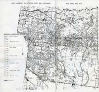
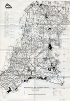
This study "Land Capability for Urban and related uses in the Berwick-Pakenham area and the Shire of Hastings" was undertaken by DF Howe, RT Costello and LD Russell of the former Soil Conservation Authority in December, 1979 as a field exercise in which procedures for assessing land capability were evaluated and further developed. It was intended that it provide the Westernport Bay Environmental Study of the Ministry for Conservation with information on land capability for use in planning.
In this study, the assessments of land capability was based on an approach which was used extensively in the U.S.A. (Olson 1964; Soil Survey Staff 1971; USDA 1973).
The results presented in this report are a guide to the levels of difficulty involved in using the land.
To view the information PDF requires the use of a PDF reader. This can be installed for free from the Adobe website (external link).
 | |
| Maps | |


