SFS18
Location: Mt Gow
Australian Soil Classification: Calcic, Epipedal, Black VERTOSOL
General Landscape Description: Flat plain.
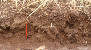
Site Description: Canola stubble in raised beds. Previously phalaris pasture was grown. Southern Farming Systems (SFS) trial site.
Geology: Weathering basaltic rock.
 SFS18 Landscape |
Soil Profile Morphology:
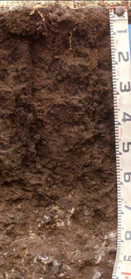
| Surface Soil |  SFS18 Profile | ||
| Ap | 0-20 cm | Very dark greyish brown (10YR3/2); large cracks visible at surface; medium clay; strongly pedal, thin surface mulch of fine polyhedral peds or sometimes a thin weak crust fractured by cracks, underlain by coarse polyhedral and subangular blocky structure; very firm to strong consistence dry; pH 5.7; abrupt change to: | |
| Subsoil | |||
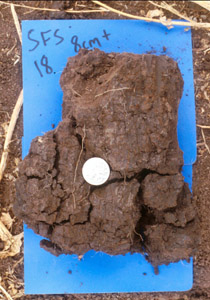
| B21t | 20-50 cm | Very dark grey (10YR3/1); heavy clay; coarse prismatic, parting to coarse polyhedral structure (main prismatic units clearly defined by deep cracking to 60+ cm depth); slickensides (>50 mm) begin at 45 cm depth; pH 7.0; gradual change to: | |
| B22ss | 50-70 cm | Very dark greyish brown (10YR3/2) with many dark yellowish brown (10YR4/4) mottles; heavy clay; prominent slickensides evident; pH 7.8; gradual change to: | |
| C | 70+ cm | Hard rounded weathering basaltic rock; pH 8.6. | |
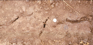
 Soil structure in raised bed. |  Wide (>10mm) cracks in bed farrow, associated with subsoil structure. |  Subsoil peds. |
Key Profile Features:
- Clay texture throughout soil profile.
- Significant cracking when profile is dry.
- Prominent slickensides in subsoil.
Soil Profile Characteristics:
pH | Salinity Rating | |||
Surface (A1 horizon) | Moderately Acid | Low-Medium | Non-Sodic | None1 |
Subsoil (B21 horizon) | Neutral | Low-Medium | Sodic | Slight2 |
Deeper subsoil (at 50+ cm) | Strongly Alkaline | Low-Medium | Strongly Sodic | Moderate |

| The salinity rating is low to medium throughout the whole profile. | The surface is non sodic. The upper subsoil is sodic becoming strongly sodic with depth. | The clay content is moderate throughout the profile. |
Horizon | Horizon Depth (cm) | pH (water) | pH (CaCl2) | EC dS/m | NaCl % | Exchangeable Cations | |||
Ca | Mg | K | Na | ||||||
meq/100g | |||||||||
Ap | 0-20 | 5.7 | 5.2 | 0.46 | 0.03 | 7.9 | 7.9 | 2.4 | 0.8 |
B21 (i) | 20-30 | 7.0 | 6.3 | 0.43 | 0.02 | 7.4 | 13 | 2.9 | 3.6 |
B21 (ii) | 30-50 | 7.8 | 7.2 | 0.31 | 0.02 | 7.8 | 14 | 2.4 | 4.8 |
B22 | 50-70 | 8.6 | 7.8 | 0.47 | 0.03 | 8.1 | 18 | 1.9 | 6.6 |
Horizon | Horizon Depth (cm) | Oxidisable Organic Carbon % | Total Nitrogen % | Exchangeable Aluminium mg/kg | Exchangeable Acidity meq/100g | Field Capacity pF2.5 | Wilting Point pF4.2 | Coarse Sand (0.2-2.0 mm) | Fine Sand (0.02-0.2 mm) | Silt (0.002-0.02 mm) | Clay (<0.002 mm) |
Ap | 0-20 | 3.3 | 0.37 | 5 | 16 | 38 | 23 | 4 | 29 | 17 | 41 |
B21 (i) | 20-30 | 44 | 27 | 2 | 26 | 14 | 51 | ||||
B21 (ii) | 30-50 | 47 | 31 | 2 | 26 | 15 | 51 | ||||
B22 | 50-70 | 52 | 35 | 2 | 24 | 17 | 53 |
Management Considerations:
Whole Profile
- Plant available water capacity (PAWC) is considered to be low/medium (estimated at 100 mm) in the upper 70 cm of this soil profile. Effective rooting depth (ERD) is restricted to 70 cm due to the basalt below this depth.


