
IS5
Location: Coromby
Morphological Soil Type: Longerenong Clay
Australian Soil Classification: Endocalcareous-Endohypersodic, Self-Mulching, Red VERTOSOL
Northcote Factual Key: Ug 5.3
Great Soil Group: red clay
Mapping Unit: Kalkee Clay and Longerenong Clay co-dominant complex.
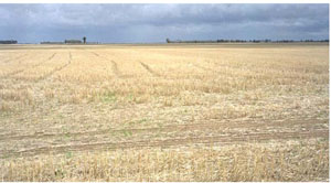
General Landscape Description: Level plain.
Site Description: The site was cultivated and cropped.
Geology: Tertiary (late Miocene to Pliocene).
Native Vegetation: This site was probably within the Buloke (Casurarina luehmannii) association savanna woodland formation.
 IS5 Landscape |
Soil Profile Morphology:
Surface Soil
| A1 | 0-10 cm | Brown (10YR4/3); light clay; subplastic; cracking and self-mulching surface condition; weak coarse granular structure; weak consistence dry; pH 8.8; sharp and smooth change to: | 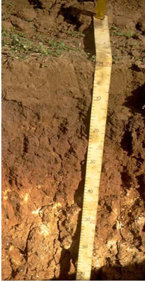 IS5 Profile |
| Subsoil | |||
| B21 | 10-30 cm | Reddish brown (5YR4/4); medium clay; plastic; strong very coarse prismatic structure; very strong consistence dry, sticky consistence wet; pH 9.1; clear and smooth change to: | |
| B22k | 30-65 cm | Yellowish red (5YR4/5) with fine faint reddish yellow (7.5YR6/6) mottles; light clay; subplastic; weak coarse subangular blocky structure; strong consistence dry, sticky consistence wet; contains a few (2-10 %) soft carbonates; pH 9.3: | |
| B23k | 65-100 cm | Yellowish red (5YR4/5) with faint reddish yellow (7.5YR6/6) mottles; heavy clay; subplastic; weak coarse subangular blocky structure; strong consistence dry, sticky consistence wet; contains a few (2-10 %) soft carbonates; pH 9.1: | |
| B24k | 100-145 cm | Yellowish red (5YR4/5) with fine faint reddish yellow (7.5YR6/6) mottles; heavy clay; subplastic; weak coarse subangular blocky structure; strong consistence dry, sticky consistence wet; contains a few (2-10 %) soft carbonates; pH 8.9; gradual change to: | |
| B31 | 145-180 | Brown (7.5YR5/5); medium clay; weak coarse subangular blocky structure; pH 8.9; gradual boundary to: | |
| B32 | 180-215 cm | Strong brown (7.5YR5/6) with pale brown (10YR6/3) mottles; medium clay; weak coarse subangular blocky structure; pH 8.9. | |
Key Profile Features:
- High clay content throughout soil profile.
- Vertic properties (ie. significant shrink-swell characteristic).
- Self-mulching surface soil.
Soil Profile Characteristics:
pH | Salinity Rating | |||
Surface (A1 horizon) | Strongly Alkaline | Low | Non-Sodic | None |
Subsoil (B21 horizon) | Very Strongly Alkaline | Low | Sodic | Moderate |
Deeper Subsoil (100-145 cm) | Strongly Alkaline | High - Very High | Very Strongly Sodic | None1 |
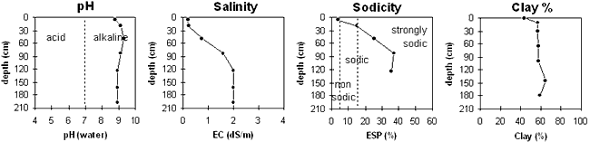
| The surface soil is strongly alkaline. The upper subsoil is very strongly alkaline becoming strongly alkaline with depth. | The salinity rating is low in the surface and upper subsoil becoming high to very high with depth. | The surface is non-sodic. The subsoil is sodic becoming strongly sodic with depth. | The clay content is high throughout the profile. |
Chemical and Physical Analysis:
Horizon | Sample Depth cm | pH H2O | EC dS/m | Sodium Chloride % | Exchangeable Calcium cmol-/kg | Exchangeable Magnesium cmol-/kg | Exchangeable Potassium cmol-/kg | Exchangeable Sodium cmol-/kg | Total Nitrogen % | Organic Carbon % | Exchangeable Acidity cmol-/kg | Field Capacity -30okPa | Permanent Wilting Point -1500okPa | Coarse Sand % | Fine Sand % | Silt % | Clay % |
A1 | 0–10 | 8.8 | 0.18 | 0.01 | 19.5 | 4 | 2.1 | 1 | 0.08 | 0.09 | 1.2 | 25.8 | 14.7 | 25 | 22 | 8 | 44 |
B21 | 10–30 | 9.1 | 0.22 | 0.03 | 15.6 | 9.7 | 1.8 | 4.7 | 0.08 | 0.75 | 24.9 | 19 | 18 | 5 | 57 | ||
B22k | 30–65 | 9.3 | 0.75 | 0.07 | 10.2 | 13.8 | 1.9 | 8.8 | 0.04 | 0.38 | 33.3 | 18 | 15 | 3 | 57 | ||
B23k | 65–100 | 9.1 | 1.6 | 0.17 | 6.9 | 12.9 | 2 | 12.7 | 0.02 | 0.14 | 26.2 | 13 | 14 | 8 | 58 | ||
B24k | 100–145 | 8.9 | 2 | 0.24 | 7.5 | 15.9 | 2.2 | 14.1 | 0.02 | 0.15 | 27.1 | 10 | 9 | 7 | 58 | ||
B31 | 145–180 | 8.9 | 2.01 | 0.27 | 12 | 15 | 8 | 65 | |||||||||
B32 | 180–215 | 8.9 | 2 | 0.31 | 9 | 11 | 8 | 59 |
Management Considerations:
Whole Profile
- The strongly alkaline profile suggests that some nutrients (eg. iron, manganese, zinc, copper) may be poorly available to plants. Nutrient deficiencies can be assessed by plant tissue analysis.
- Plant available water capacity (PAWC) is considered to be relatively low (estimated at 55 mm). This is based on available laboratory data and assumes an effective rooting depth of 30 cm. The effective rooting depth will be restricted by the high level of soluble salts and the strongly sodic nature of the deeper subsoil.
Surface (A) Horizon
- The surface soil is self-mulching which provides a good seed bed that is friable and easily worked.
- When the soil is dry, heavy rains will move down soil cracks. This rapid recharge can be valuable for the survival of plants near wilting. When wet, the soil will swell and further infiltration of water will be relatively slow.
- Tillage of cracking clay soils should be avoided if the soil is wet (ie. wetter than the plastic limit). At such moisture conditions, excessive tillage, trafficking or overstocking could result in structural damage (eg. compaction, smearing) occurring. Ideally, tillage and trafficking should be carried out on clay soils when the soil is drier than the plastic limit, down to at least the tillage depth.
Subsoil (B) Horizons
- The salinity rating becomes medium below 30 cm depth and high to very high below 65 cm depth. These levels of soluble salts are likely to restrict the growth of salt sensitive plant species (eg. faba beans, linseed, chickpeas and lupins).
- The subsoil below 25 cm depth becomes strongly sodic and has a low exchangeable calcium to magnesium ratio (ie. < 1). Dispersion occurs as a result and root and water movement will be restricted.
- The high level of exchangeable sodium and magnesium in the deeper subsoil may also result in nutrient imbalances and may also have a toxic effect on some plants.
- The subsoil displays strong vertic properties which indicates that significant shrinking and swelling occurs with wetting and drying cycles. This may disturb the roots of some plant species and has engineering implications (eg. disturbance to building foundations and fencelines).
Profile Described By: John Martin, Nabil Badawy, Ron Cawood, Geoff Pope, John Galea, John Turner (1970).
Reference: "Major Agricultural Soils of the Wimmera Irrigation Area". John Martin, Mark Imhof, Lourey Ruth, Rob Nink, Karen DePlater, Paul Rampant, Sonia Thompson, S. Alexander. Department of Natural Resources and Environment, Victoria. 1996.
© State of Victoria (Agriculture Victoria) 1996 - .

This work, Victorian Resources Online, is licensed under a Creative Commons Attribution 4.0 licence. You are free to re-use the work under that licence, on the condition that you credit the State of Victoria (Agriculture Victoria) as author, indicate if changes were made and comply with the other licence terms.
The licence does not apply to ‘branding’ or some ‘images or photographs’ that may be owned by third parties. We ask you to seek prior approval to use images using the VRO feedback form. Access to higher quality images can also be provided on request.
This page was last updated on .