
IS26
Location: Haven
Soil Type: Quantong Sand (Shallow Phase).
Australian Soil Classification: Vertic (& Calcic), Mottled-Subnatric, Brown SODOSOL; (thick, sandy/clayey).
Northcote Factual Key: Dy 5.43.
Great Soil Group: solodised solonetz.
Mapping Unit: Quantong Sand.
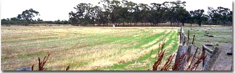 IS26 Landscape. Mid-slope of a dune in the background. |
General Landscape Description: Mid-slope of dune slope.
Geology: Late Pleistocene to Holocene. Quaternary Lowan Formation: aeolian fine to medium grained dune sand
Native Vegetation: The site was probably within the Apple Box (Eucalyptus aromaphloia), Yellow Box (E. melliodora), Brown Stringybark (E. baxterii), heath woodland and tall woodland formation.
Soil Profile Morphology:
Surface Soil
| A11 | 0-30 cm | Light brownish grey (10YR6/2); sand; single grain structure; loose surface condition; pH 6.9; sharp and wavy change to: | 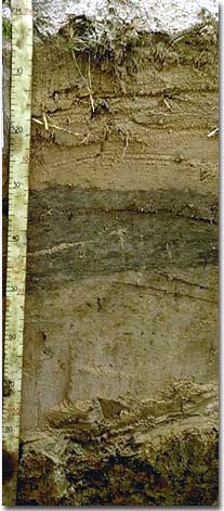 IS26 Profile |
| A12 | 30-45 cm | Grey (10YR5/1); sand; single grain structure; pH 6.7; sharp and wavy change to: | |
| A2 | 45-75 cm | Light brownish grey (10YR6/2) conspicuously bleached (10YR7/2d); sand; single grain structure; pH 6.8; sharp and wavy change to: | |
| Subsoil | |||
| B1 | 75-90 cm | Yellowish brown (10YR5/6) with distinct greyish brown (10YR5/2) mottles; sandy clay loam; very plastic wet; massive structure; very strong consistence dry, slightly sticky consistence wet; pH 7.2: | |
| B2 | 90-100 cm | Yellowish brown (10YR5/6) with distinct greyish brown (10YR5/2) mottles; medium clay; very plastic wet; moderate columnar structure; very strong consistence dry, slightly sticky consistence wet; pH 7.6; gradual change to: | |
| B31k | 100-150 cm | Pale olive (5Y6/3) with distinct pale brown (10YR6/3) mottles; light clay; plastic; contains large slickensides; strong consistence dry, slightly sticky consistence wet; contains a common (10-20 %) amount soft carbonate; pH 9.2; sharp change to: | |
| B32k | 150-190 cm | Pale yellow (5Y7/3) with faint yellow (10YR7/6) mottles; light clay; contains a common (10-20 %) amount of soft carbonate; pH 9.5: | |
| B33k | 190-240 cm | Pale yellow (5Y7/3) with faint yellow (10YR7/6) mottles; light clay; contains a common (10-20 %) amount of soft carbonate; pH 9.4. | |
Key Profile Features:
- Strong texture contrast between sandy surface (A) horizons (< 3% clay) and subsoil (B1) horizon (29% clay).
- Columnar structure in upper subsoil.
- Vertic properties (ie. slickensides present) in deeper subsoil.
Soil Profile Characteristics:
| - | pH | Salinity Rating | ||
Surface (A1 horizon) | Slightly Acid | Very Low | Non-Sodic | None |
Subsoil (B21 horizon) | Slightly Alkaline | Very Low | Sodic | Complete |
Deeper Subsoil (at 1 m) | Very Strongly Alkaline | Low | Sodic | Complete |
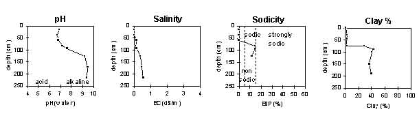
| The surface soil is slightly acid. The subsoil is slightly alkaline becoming very strongly alkaline at depth. | The salinity rating is very low in the surface and upper subsoil becoming low with depth. | The surface is non-sodic. The subsoil is sodic. | The clay content increases markedly at the surface / subsurface boundary. |
Chemical and Physical Analysis:
Horizon | Sample Depth cm | pH H2O | EC dS/m | Sodium Chloride % | Exchangeable Calcium cmol-/kg | Exchangeable Magnesium cmol-/kg | Exchangeable Potassium cmol-/kg | Exchangeable Sodium cmol-/kg | Total Nitrogen % | Organic Carbon % | Bulk Density | Exchangeable Acidity cmol-/kg | Field Capacity -30okPa | Permanent Wilting Point -1500okPa | Coarse Sand % | Fine Sand % | Silt % | Clay % |
A11 | 0–30 | 6.9 | 0.01 | 0.01 | 0.2 | 0 | 0 | 0 | 0.01 | 0.19 | 1.47 | 1.2 | 0.5 | 59 | 39 | 1 | 1 | |
A12 | 30–45 | 6.7 | 0.01 | 0 | 0.5 | 0.1 | 0 | 0 | 0.01 | 0.2 | 1.66 | 0.7 | 56 | 41 | 0 | 3 | ||
A2 | 45–75 | 6.8 | 0.15 | 0 | 0.5 | 0 | 0 | 0 | 0.01 | 0.17 | 1.49 | 0.9 | 0.6 | 43 | 53 | 1 | 2 | |
B1 | 75–90 | 7.2 | 0.1 | 0.01 | 2.7 | 4.3 | 0.6 | 1.3 | 0.03 | 0.38 | 1.61 | 6.5 | 10.7 | 37 | 31 | 3 | 29 | |
B2 | 90–100 | 7.6 | 0.15 | 0.02 | 5.7 | 8.7 | 0.7 | 2.6 | 0.04 | 7.2 | 5.4 | 35 | 20 | 1 | 43 | |||
B31k | 100–150 | 9.2 | 0.37 | 0.03 | 7.3 | 12.2 | 0.9 | 2.7 | 0.02 | 0.13 | 1.52 | 17.9 | 25 | 28 | 1 | 41 | ||
B32k | 150–190 | 9.5 | 0.48 | 0.06 | 18.3 | 16 | 7 | 4 | 37 | |||||||||
B33k | 190–240 | 9.4 | 0.56 | 0.08 | 20.3 | 18 | 14 | 3 | 40 |
Management Considerations:
Whole Profile
- Plant available water capacity (PAWC) is considered to be low (estimated at 54 mm). This is based on available laboratory data and assumes an effective rooting depth of 75 cm. Rooting depth will probably be restricted by the dense and strongly dispersive subsoil.
Surface (A) Horizons
- The sandy surface horizons have a very low water holding capacity and inherent lack of fertility. Increasing the organic matter levels of the surface horizon will help to improve these characteristics as well as assisting in soil aggregation.
- These sandy soils can often show a degree of water repellence which restricts water infiltration.
- The very low wilting point value (ie. 0.5%) of the surface (A1) horizon indicates that plants will be able to utilise very light rains when the soil is dry. However, due to the low water storage capacity, plants will soon suffer moisture stress unless further rain falls occur.
- Infiltration of water will be rapid in the surface soil and water will rapidly move down towards the subsoil. The presence of a conspicuously bleached A2 horizon indicates that this horizon is periodically waterlogged as water sits on the slowly permeable subsoil.
Subsoil (B) Horizons
- The dense and coarsely structured subsoil is sodic and disperses completely in water. These conditions will significantly restrict root and water movement into the subsoil. The subsoil is also highly erodible to water if the sandy surface horizons are removed.
Profile Described By: John Martin, Nabil Badawy, Ron Cawood, Geoff Pope, John Galea, John Turner (1970).
Reference: "Major Agricultural Soils of the Wimmera Irrigation Area". John Martin, Mark Imhof, Lourey Ruth, Rob Nink, Karen DePlater, Paul Rampant, Sonia Thompson, S. Alexander. Department of Natural Resources and Environment, Victoria. 1996.
© State of Victoria (Agriculture Victoria) 1996 - .

This work, Victorian Resources Online, is licensed under a Creative Commons Attribution 4.0 licence. You are free to re-use the work under that licence, on the condition that you credit the State of Victoria (Agriculture Victoria) as author, indicate if changes were made and comply with the other licence terms.
The licence does not apply to ‘branding’ or some ‘images or photographs’ that may be owned by third parties. We ask you to seek prior approval to use images using the VRO feedback form. Access to higher quality images can also be provided on request.
This page was last updated on .