
IS16
Location: Murtoa
Soil Type: Drung Sandy Loam
Australian Soil Classification: Calcic, Mesonatric, Red SODOSOL
Northcote Factual Key: Dr 2.43
Great Soil Group: solodic soil
Mapping Unit: Drung Sandy Loam.
General Landscape Description: Level surface on a prior stream levee within a flood plain.
Site Description: Cleared and cultivated area.
Geology: Late Tertiary to Quaternary Shepparton Formation.
Native Vegetation: Probably originally Yellow Gum (Eucalyptus leucoxylon).
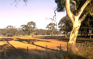 IS16 Landscape |
Soil Profile Morphology:
Surface Soil
| A1 | 0-5 cm | Dark yellowish brown (10YR4/4); light fine sandy loam; hardsetting surface condition; weak coarse granular structure; very strong consistence dry; pH 5.9; sharp and irregular change to: | 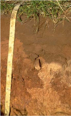 IS16 Profile |
| A2e | 5-20 cm | Dark brown (7.5YR4/4) conspicuously bleached (7.5YR7/3); light fine sandy loam; weak coarse granular structure; weak consistence dry; pH 6.0; sharp change to: | |
| A3e | 20-25 cm | Dark brown (7.5YR4/4) conspicuously bleached (7.5YR7/3); fine sandy loam; massive structure; very strong consistence dry; pH 8.5; sharp and wavy change to: | |
| Subsoil | |||
| B21 | 25-45 cm | Yellowish red (5YR4/6); medium clay; weak, very coarse prismatic structure; pH 9.0; gradual change to: | |
| B22 | 45-70 cm | Strong brown (7.5YR5/6); light clay; weak, coarse prismatic structure; pH 9.5; gradual change to: | |
| B23k | 70-95 cm | Strong brown (7.5YR5/6); medium clay; weak coarse prismatic structure; contains a few (2-10 %) soft carbonates; pH 9.7; sharp and wavy change to: | |
| B31k | 95-130 cm | Brown (10YR5/3) with distinct yellowish red (5YR4/6) mottles; sandy clay; weak coarse subangular blocky structure; contains a few (2-10 %) soft carbonates; pH 9.7. | |
Key Profile Features:
- Strong texture contrast between surface (A) horizons (< 16% clay) and subsoil (B21) horizon (40% clay).
Soil Profile Characteristics:
pH | Salinity Rating | |||
Surface (A1 horizon) | Moderately Acid | Low | - | None1 |
Subsoil (B21 horizon) | Strongly Alkaline | Low | Strongly Sodic | Strong |
Deeper Subsoil (at 1 m) | Extremely Alkaline | High | Very Strongly Sodic | - |
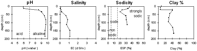
| The surface soil is moderately acid. The upper subsoil is strongly alkaline becoming very extremely alkaline with depth. | The salinity rating is low in the surface and upper subsoil becoming high with depth. | The profile is strongly sodic throughout. | The clay content jumps markedly at the surface subsoil boundary. |
Chemical and Physical Analysis:
Horizon | Sample Depth cm | pH | EC dS/m | Sodium Chloride % | Exchangeable Calcium cmol-/kg | Exchangeable Magnesium cmol-/kg | Exchangeable Potassium cmol-/kg | Exchangeable Sodium cmol-/kg | Total Nitrogen % | Organic Carbon % | Bulk Density | Exchangeable Acidity cmol-/kg | Field Capacity -30okPa | Permanent Wilting Point -1500okPa | Coarse Sand % | Fine Sand % | Silt % | Clay % | |
H2O | CaCl2 | ||||||||||||||||||
A1 | 0–5 | 5.9 | 0.06 | 0.01 | 1.4 | 0.4 | 0.3 | 2.7 | 0.05 | 0.7 | 2.7 | 2.2 | 13 | 71 | 7 | 9 | |||
A2e | 5–20 | 6 | 5.2 | 0.02 | 0.01 | 2.2 | 0.7 | 0.2 | 0.1 | 0.02 | 0.27 | 1.45 | 0.7 | 11.7 | 1.4 | 12 | 71 | 11 | 6 |
A3e | 20–25 | 8.5 | 0.09 | 0.02 | 1.3 | 2.3 | 0.3 | 1.2 | 0.03 | 0.2 | 0.5 | 5.4 | 9 | 62 | 11 | 16 | |||
B21 | 25–45 | 9 | 0.17 | 0.04 | 6.4 | 8.0 | 1.0 | 4.0 | 0.04 | 0.22 | 1.0 | 15.1 | 4 | 46 | 9 | 40 | |||
B22 | 45–70 | 9.5 | 0.67 | 0.1 | 2.6 | 7.6 | 1.0 | 4.7 | 0.02 | 0.14 | 1.44 | 30.5 | 13.7 | 2 | 45 | 18 | 33 | ||
B23k | 70–95 | 9.7 | 0.85 | 0.13 | 2.6 | 7.3 | 0.9 | 4.7 | 0.02 | 0.13 | 12.8 | 11 | 27 | 28 | 30 | ||||
B31k | 95–130 | 9.7 | 0.72 | 0.11 | 2.4 | 8.6 | 1.0 | 5.6 | 0.02 | 0.1 | 1.6 | 13.1 | 23 | 42 | 5 | 29 | |||
B32 | 130–165 | 9.6 | 1.08 | 0.16 | 18.9 | 16 | 31 | 5 | 41 | ||||||||||
B33 | 165–205 | 9.6 | 1.08 | 0.16 | 19.5 | 14 | 29 | 7 | 44 | ||||||||||
Management Considerations:
Whole Profile
- Plant available water capacity (PAWC) is considered to be low (estimated at 55 mm). This is based on available laboratory data and assumes an effective rooting depth of 40 cm. Rooting depth will be restricted by the strongly sodic deeper subsoil with a medium to high level of soluble salts.
- The surface soil has a very high fine sand content (ie. 71%) and is hardsetting when dry. When cultivated in a dry condition it will become ‘powdery’ and subsequent rainfall may result in surface sealing occurring. Organic matter is important for maintaining aggregation on soils such as these which are liable to slake when rapidly wet. Organic matter levels will decrease with cropping and should be improved by adopting residue retention, minimum tillage and pasture rotations. As well as improving aggregation, organic matter assists in increasing soil water holding capacity and fertility.
- The surface soil disperses slightly after remoulding. This indicates that some structural degradation may occur if cultivation occurs when the soil is wet.
- The surface horizons have a low water storage capacity. The low wilting point value (ie. 2%) indicates that plants will be able to utilise light rains during dry periods. However, due to the low water storage capacity, plants will suffer moisture stress unless further rains occur.
- The presence of conspicuous bleaching in the subsurface (A2) horizons indicates that periodic waterlogging occurs above the slowly permeable subsoil. These bleached horizons also have a low inherent fertility.
- The dense and coarsely structured upper subsoil is strongly sodic and dispersive. Levels of exchangeable calcium relative to magnesium are also low (ie. <1). These conditions will result in water and root movement being significantly restricted in the subsoil.
- At 45 cm depth, the level of soluble salts increases to a medium level. High levels are encountered from 70 cm in the soil profile. These levels may restrict the growth of salt sensitive species (eg. faba beans, chickpeas, lupins).
- The subsoil is strongly alkaline which indicates that some nutrients (eg. iron, manganese, copper, zinc) may be poorly available to plants.
Profile Described By: John Martin, Nabil Badawy, Ron Cawood, Geoff Pope, John Galea, John Turner (1970).
Reference: "Major Agricultural Soils of the Wimmera Irrigation Area". John Martin, Mark Imhof, Lourey Ruth, Rob Nink, Karen DePlater, Paul Rampant, Sonia Thompson, S. Alexander. Department of Natural Resources and Environment, Victoria. 1996.
© State of Victoria (Agriculture Victoria) 1996 - .

This work, Victorian Resources Online, is licensed under a Creative Commons Attribution 4.0 licence. You are free to re-use the work under that licence, on the condition that you credit the State of Victoria (Agriculture Victoria) as author, indicate if changes were made and comply with the other licence terms.
The licence does not apply to ‘branding’ or some ‘images or photographs’ that may be owned by third parties. We ask you to seek prior approval to use images using the VRO feedback form. Access to higher quality images can also be provided on request.
This page was last updated on .