
IS15
Location: Murtoa
Australian Soil Classification: Calcic, Mottled-Mesonatric, Red SODOSOL
Northcote Factual Key: Dy3.43
Great Soil Group: solodized solonetz
Soil Type: Haven Sandy Loam.
General Landscape Description: Terrace flat within an anastomotic plain.
Geology: Quaternary Shepparton Formation: fluvial silt, sand and minor gravel
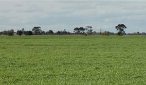 IS15 Landscape |
Soil Profile Morphology:
Surface soil
| A1 | 0-5 cm | Brown (7.5YR4/4); fine sandy loam; plastic; hard setting surface condition; weak coarse granular structure; weak consistence dry; pH 6.2; sharp and wavy boundary to: | 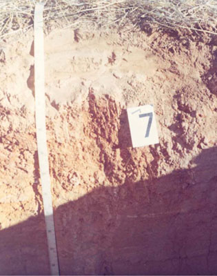 IS14 Profile |
| A2e | 5-10 cm | Brown (7.5YR4/4) conspicuously bleached (7.5YR7/2d); fine sandy loam; weak coarse granular structure; weak consistence dry; pH 8.2; sharp and wavy boundary to: | |
| A3e Subsoil | 10-15 cm | Conspicuously bleached (7.5YR7/2d); sandy loam; massive (structureless) with cemented capping; weak consistence dry; pH 8.2; sharp and wavy boundary to: | |
| B21 | 15-50 cm | Yellowish red (5YR5/6) with reddish brown (2.5YR4/4) mottles; medium clay; plastic; moderate very coarse columnar structure; strong consistence dry; sticky consistence wet; pH 9.3: | |
| B22 | 50-90 cm | Yellowish red (5YR5/6) with reddish brown (2.5YR4/4) mottles; medium clay; plastic; moderate very coarse columnar structure; strong consistence dry; sticky consistence wet; pH 9.8; clear and wavy boundary to: | |
| B31k | 90-140 cm | Yellowish brown (10YR5/4); sandy clay loam; plastic; weak coarse subangular blocky structure; strong consistence dry; moderately sticky consistence wet; few (2-10%) soft carbonate segregations in bands; pH 9.8. |
Chemical and Physical Analysis:
Horizon | Sample Depth cm | pH | EC dS/m | Sodium Chloride % | Exchangeable Calcium cmol-/kg | Exchangeable Magnesium cmol-/kg | Exchangeable Potassium cmol-/kg | Exchangeable Sodium cmol-/kg | Total Nitrogen % | Organic Carbon % | Bulk Density | Exchangeable Acidity cmol-/kg | Field Capacity -30okPa | Permanent Wilting Point -1500okPa | Coarse Sand % | Fine Sand % | Silt % | Clay % | |
H2O | CaCl2 | ||||||||||||||||||
A1 | 0–5 | 6.2 | 0.09 | 0.01 | 1.7 | 0.6 | 0.7 | 0.1 | 0.1 | 1.42 | 3 | 3.6 | 7 | 68 | 15 | 8 | |||
A2e | 5–10 | 6.2 | 5 | 0.06 | 0.01 | 2.8 | 0.9 | 0.4 | 0.1 | 0.05 | 0.86 | 1.37 | 2.1 | 15.1 | 2.7 | 8 | 69 | 15 | 8 |
A3e | 10–15 | 8.2 | 0.09 | 0.02 | 1.9 | 2.1 | 0.4 | 0.8 | 0.03 | 0.29 | 0.9 | 5.2 | 6 | 61 | 18 | 15 | |||
B21 | 15–50 | 9.3 | 0.39 | 0.04 | 4.3 | 8.3 | 1.4 | 4.2 | 0.04 | 0.2 | 17.1 | 3 | 37 | 16 | 44 | ||||
B22 | 50–90 | 9.8 | 0.57 | 0.06 | 1.4 | 5.3 | 0.7 | 4.5 | 0.02 | 0.07 | 1.43 | 30.4 | 10.9 | 1 | 51 | 22 | 26 | ||
B31k | 90–140 | 9.8 | 0.36 | 0.04 | 1 | 3.6 | 0.4 | 3 | 0.01 | 0.04 | 1.53 | 20 | 1 | 69 | 14 | 16 | |||
B32 | 140–195 | 9.8 | 0.32 | 0.03 | 8.7 | 1 | 61 | 19 | 19 | ||||||||||
B33 | 195–230 | 8.9 | 0.23 | 0.04 | 15 | 40 | 18 | 27 | |||||||||||
Management Considerations:
- Texture contrast profile with clay dominant in upper subsoil
- Alkaline soil, slightly decreasing at depth, high level of nutrients in upper subsoil (B22 horizon)
- Thin surface and subsurface horizon with, poor structure and high fine sand component
- Subsurface soil is leached with fewer nutrients than above or below
- Subsoil is sodic, becoming strongly sodic with depth and slight h salinity values in subsoil
- Subsoil is mottled indicating some restricted drainage
- Landform element, plain; slow site drainage, unless near drainage line
Profile Described By: John Martin, Nabil Badawy, Ron Cawood, Geoff Pope, John Galea, John Turner (1970).
© State of Victoria (Agriculture Victoria) 1996 - .

This work, Victorian Resources Online, is licensed under a Creative Commons Attribution 4.0 licence. You are free to re-use the work under that licence, on the condition that you credit the State of Victoria (Agriculture Victoria) as author, indicate if changes were made and comply with the other licence terms.
The licence does not apply to ‘branding’ or some ‘images or photographs’ that may be owned by third parties. We ask you to seek prior approval to use images using the VRO feedback form. Access to higher quality images can also be provided on request.
This page was last updated on .