
Land Degradation
See also Land Degradation in Victoria
Potential land degradation in the Wimmera include water erosion (ie: sheet, gully, tunnel and deposition), wind erosion (sheet and deposition) and destruction by pest plants and animals. The Wimmera Catchment Management Authority (external link) has produced a Rabbit Action Plan (WCMA, 1999a) and a Weed Action Plan (WCMA, 1999b).
| Meanwhile, erosion susceptibilities are scored from zero to three and then rated for an erosion potential of nil, low, moderate or high. A class of nil indicates that the susceptibility is predicted to be generally below the limits of detection, and thus comparable to degradation under pre-European conditions. Measurement and description of relevant parameters follows McDonald et al (1990). Data on diagnostic characteristics are generally sufficient for broad predictions of susceptibility. Prediction based on chemical data are less reliable than physical data, and are tentative in areas without laboratory data for soils. Data on soil mottling are also unreliable (Rees, 2000). The Wimmera region of Victoria generally has insignificant to low susceptibility to water erosion throughout. However, there are small patches of land in the far south-east of the catchment that are classified as having a medium or high susceptibility to water erosion. These areas are characterised by the steep mountains and hills of the Grampians Ranges and stranded beach ridges. These stranded beach ridge landforms are also susceptible to wind erosion. |
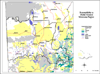
| The Susceptibility to Water Erosion map is intended to be used with existing Land Systems data to determine the likely impact of water erosion for areas within the Wimmera region. Measurement is based on McDonald et. al.(1990) and uses soil depth (the average depth to solid rock). Rating scores are based on observations in hilly sub-humid areas where water erosion is relatively severe. These scores are rated from nil to high. |
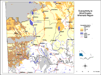
The Wimmera’s susceptibility to wind erosion is generally insignificant to low - ie. the lower catchment is mostly susceptible to insignificant erosion, whilst the upper catchment is likely to incur low rates of wind erosion. However, there are significant patches of land surrounding the Big and Little Desert National Parks that are prone to medium rates of wind erosion. The riparian zone along parts of the Wimmera River and Yarriambiack Creek and a significant patch of land lying just north-west of Nhill are also mildly susceptible to erosion by wind. There are also parts of the region surrounding the Big and Little Desert that are significantly susceptible. Other areas of high susceptibility are the far north-west of the catchment and smaller land masses just south of Horsham.
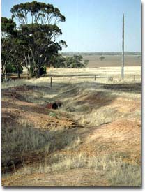
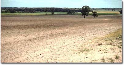 Sandier soils in the foreground are most susceptible to wind erosion |  Gully erosion near Stawell |
Those landforms incurring high susceptibility to wind erosion in the Wimmera are usually characterised by east-west dunes and by treeless plains which abut public land. Areas with a relatively medium susceptibility are often characterised by stranded beach ridges which usually trend in a NNW-SSE direction.
| The Susceptibility to Wind Erosion map is intended to be used with existing Land Systems data to determine the likely impact of wind erosion for areas within the Wimmera region. Criterion is based on Lorimer (1985) and uses surface texture in semi-arid to sub-humid areas and exposure to particularly strong winds in humid areas. The criterion for susceptibility to wind erosion in semi-arid areas is surface soil texture. Scores are given to rate texture from nil to high. |
References
McDonald, R.C., Isbell, R.F., Speight, J.G., Walker, J., and Hopkins, M.S., (1990). Australian Soil and Land Survey Handbook. 2nd Edn. Inkata Press, Melbourne.
Rees, D. (2000). Land Systems of Victoria, 3rd edn. Centre for Land Protection Research Technical Report no. 56. Bendigo.
WCMA (1999a). Wimmera Rabbit Action Plan. Horsham.
WCMA (1999b). Weed Action Plan. Horsham.
© State of Victoria (Agriculture Victoria) 1996 - .

This work, Victorian Resources Online, is licensed under a Creative Commons Attribution 4.0 licence. You are free to re-use the work under that licence, on the condition that you credit the State of Victoria (Agriculture Victoria) as author, indicate if changes were made and comply with the other licence terms.
The licence does not apply to ‘branding’ or some ‘images or photographs’ that may be owned by third parties. We ask you to seek prior approval to use images using the VRO feedback form. Access to higher quality images can also be provided on request.
This page was last updated on .