
Resource Management Units
From the Resource Management Units (RMUs) map below, it is evident that most of the Wimmera region is comprised of plains. However, some of the northern and central parts of the catchment are covered by Mallee Calcareous Sands and a small area of Western Highlands exists west of Natimuk. RMUs in the south-east of the Wimmera catchment region are more diverse. This area, within the Grampians National Park, includes a mix of Northern Footslopes, Western Highlands and Tablelands units.
| The Resource Management Units (RMU) map provides details on the legal status of land, government management recommendations, and the way the land is currently being managed. The layer facilitates analysis of current and proposed land status, management recommendations and land type. Data used to generate this map was derived from the Department of Sustainability and Environment Corporate Geospatial Database Resource Management Units layer (RMU250). | 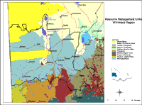 Resource Management Units |
© State of Victoria (Agriculture Victoria) 1996 - .

This work, Victorian Resources Online, is licensed under a Creative Commons Attribution 4.0 licence. You are free to re-use the work under that licence, on the condition that you credit the State of Victoria (Agriculture Victoria) as author, indicate if changes were made and comply with the other licence terms.
The licence does not apply to ‘branding’ or some ‘images or photographs’ that may be owned by third parties. We ask you to seek prior approval to use images using the VRO feedback form. Access to higher quality images can also be provided on request.
This page was last updated on .